Wendschotter and Vorsfelder Drömling with Kötherwiesen
|
Wendschotter and Vorsfelder Drömling with Kötherwiesen
|
||
|
Grassland in the nature reserve |
||
| location | Northeast of Wolfsburg , Lower Saxony | |
| surface | 722 ha | |
| Identifier | NSG BR 088 | |
| FFH area | 722 ha | |
| Bird sanctuary | 662 ha | |
| Geographical location | 52 ° 27 ' N , 10 ° 52' E | |
|
|
||
| Sea level | from 56 m to 59 m | |
| Setup date | August 6, 2020 | |
Wendschotter and Vorsfelder Drömling with Kötherwiesen denotes a nature reserve in the Lower Saxony city of Wolfsburg .
General
The nature reserve with the registration number NSG BR 088 is around 722 hectares . It is completely part of the FFH area “Drömling” and a large part of the bird sanctuary “Drömling”. The nature reserve is bordered to the northeast by the nature reserves " Northern Drömling " and " Politz and Hegholz " and on the east by the nature reserve " Southern Drömling small area" and in the southeast to the conservation area "Drömling". The approximately 609 hectare nature reserve "Wendschotter and Vorsfelder Drömling", which was designated on December 2, 1988, was completely incorporated into the newly designated nature reserve. The part of the "Drömling" nature reserve, which is adjacent to the previous nature reserve in the area of the city of Wolfsburg north of the Aller, was also incorporated into the newly designated nature reserve. The area has been under nature protection since August 6, 2020. The responsible lower nature conservation authority is the city of Wolfsburg.
The area is part of the major nature conservation project Lower Saxony Drömling , which was carried out from November 2002 to October 2012 .
description
The nature reserve is located east of the Wendschott and Vorsfelde districts of Wolfsburg in the Drömling , a low moor area that largely belongs to Saxony-Anhalt and a smaller part to Lower Saxony. The area now under protection was almost inaccessible until the 18th century. By Meliorations measures it was reclaimed made. Characteristic for the improvement measures in the 19th century were the creation of ditch systems of the Rimpau moorland culture , some of which have been preserved to this day.
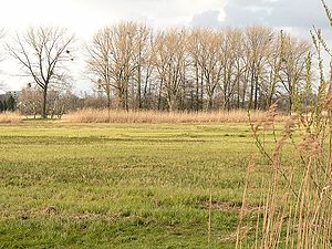
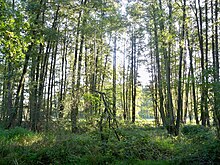
The area is characterized by mostly extensively used grassland on a low moor with a high water table, which is criss-crossed by numerous ditches . The thickness of the fens is 25 to 90 centimeters. The predominantly moist to wet grasslands are used as hay meadows and pastures . Parts of the area are occupied by reed beds , sedge beds and tall herbaceous meadows. In other parts of the nature reserve, wet bushes, alluvial and swamp forests grow thick .
The river Aller flows through the lowlands. In the west runs the Wipperaller , which partly forms the border of the nature reserve. Both rivers have been straightened in their course. The area is flooded when the rivers flood. The nature reserve is crossed roughly in the middle from southwest to northeast by the Mittelland Canal .
The Kötherwiesen between Mittellandkanal and Bundesstraße 188 adjoin in the southwest. They are characterized by a mosaic of moist to wet grassland, sedge meadows, reed beds and tall herbaceous vegetation, which was created as part of compensation measures . Still waters and isolated trees are embedded in the meadows .
The nature reserve is the habitat of species-rich flora and fauna . In the grassland complexes settle among other Inula Britannica , Yellow and Shining Meadow Rue , meadowfoam , ragged robin , meadow buttercup , nodules saxifrage , Lathyrus pratensis , Lotus pedunculatus , bird vetch , Wiesensegge , Walzensegge , tangle rush , Luzula campestris , oat grass , meadow foxtail and ordinary sweet vernal grass . For example, swamp peas and common groundweed settle in tall herbaceous vegetation and reed beds .
Alluvial and swamp forests are formed by black alder , common ash , downy birch , common bird cherry , common hazel , common oak , white elm , field elm and blood-red dogwood . Real hops join them . In the herb layer, for example, swamp sedge , forest angelica , swamp sword lily , large witch's herb , common witch's herb and bastard settle . The forests have a high proportion of old and dead wood .
The area is also a habitat for beavers and otters . It houses, among other things, the amphibians - and reptile species crested newt , common spadefoot , moor frog , tree frog , grass snake and adder . The forest lizard is also native to wooded areas . The area is the habitat of various bats , including dwarf , rough-skin , broad-winged , fringed , water bat and great and small noctule bat . The grassland areas are home to the butterfly species wet meadow mother-of-pearl butterfly, eastern large fox , large and small blue butterfly, and the grasshopper species of marsh insect and marsh grasshopper .
Birds include crane , white stork , black stork , gray heron , red and black kite , tree falcon , marsh harrier , quail , partridge , corncrake , lapwing , common snipe , reversible neck , medium , small and green woodpecker , oriole , nightingale , meadow pipit , yellow wagtail , Common reed and thrush warbler , brown and stonechat , common redstart , field owl , skylark , teal , spotted marsh grouse and water rail represented.
The waters in the nature reserve are home to, for example, common pill fern , common pennywort , frog bite , swimming pondweed , tri-furrow duckweed , small duckweed , crab claw , yellow pond rose and white water lily . They are habitat for various amphibians, the fish species bitterling , hazel , gudgeon , mud whip and wolffish , the river mussel and dragonflies , including the great moss damsel , the common wedge damsel and the glossy rush damsel .
Between 2006 and 2008, as a compensation measure for the expansion of the Mittelland Canal, abandoned fish ponds and tree nurseries in the nature reserve were converted into a natural water landscape. The construction of a bypass road from Vorsfelde in the course of federal highway 188 on the southern edge of the nature reserve is being discussed.
The area is accessed by several farm roads that can be used by pedestrians and cyclists for recreation. It often borders on other grassland areas, and on a small scale also on fields . In the west it borders on the districts of Wendschott and Vorsfelde in Wolfsburg, and in the south partly on the Vorsfelde-Süd, which is on the other side of a farm road, and an industrial area bordering the locality . Between Vorsfelde and Vorsfelde-Süd, the nature reserve is limited to the course of the Aller. The federal highway 188 crosses the area here. The Kötherwiesen border in the north partly on the federal highway 188, in the south partly on the Mittelland Canal and in the west on the local recreation area Allerpark with the Allersee .
Web links
- Nature reserve "Wendschotter and Vorsfelder Drömling with Kötherwiesen" in the database of the Lower Saxony State Office for Water Management, Coastal and Nature Conservation (NLWKN)
- Ordinance on the nature reserve "Wendschotter and Vorsfelder Drömling with Kötherwiesen" , Official Gazette for the City of Wolfsburg, 45/2020, August 5, 2020, pp. 461–481 (PDF, 4.1 MB)
Individual evidence
- ^ Drömling , profiles of the Natura 2000 areas, Federal Agency for Nature Conservation . Retrieved August 25, 2020.
- ↑ Drömling , profiles of the Natura 2000 areas, Federal Agency for Nature Conservation. Retrieved August 25, 2020.
- ^ Large-scale nature conservation project in Lower Saxony Drömling , Gifhorn district. Retrieved August 25, 2020.
- ↑ Lower Saxony Drömling , Federal Agency for Nature Conservation. Retrieved August 25, 2020.
- ↑ Nature conservation at the MLK im Drömling , press release, Wasserstraßen-Neubauamt Helmstedt , May 30, 2006 (PDF; 33 kB), accessed on August 26, 2011.
- ↑ B 188: According to the SPD, Steekgraben is not a solution. Wolfsburger Allgemeine Zeitung , August 4, 2014, accessed on March 23, 2018.


