Yan Nawa
| Yan Nawa ยานนาวา |
|
|---|---|
| Data | |
| Province: | Bangkok |
| Surface: | 16.662 km² |
| Residents: | 81,162 (2013) |
| Population density : | 5333.6 U./km² |
| ZIP : | 10120 |
| Geocode : | 1012 |
| map | |

|
|
| Bangkok boroughs | |
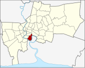
Yan Nawa ( Thai ยานนาวา , also: Yannawa ) is one of the 50 khet (districts) in Bangkok , the capital of Thailand . Yan Nawa is a southern urban district and is located on the east bank of the south bend of the Mae Nam Chao Phraya ( Chao Phraya River ).
geography
The neighboring districts are clockwise from the north: Sathon , Khlong Toei , Phra Pradaeng of Samut Prakan Province and Rat Burana (both on the opposite bank of Mae Nam Chao Phraya) and Bang Kho Laem .
history
In the past, Yan Nawa was called Ban Tavoy ( Tavoy Village, บ้าน ทวาย in Thai ) or Ban Kok Khwai ( Water Buffalo Pen Village, บ้าน คอก , in Thai ), as a large number of the residents of Tavoy City came from the often drove their water buffalo to market for sale. In the reign of King Chulalongkorn (Rama V) it became Ban Tavoy district . It was later renamed again to Amphoe Yan Nawa in accordance with the renaming of Wat Ban Tavoy to Wat Yan Nawa . In 1972 Yan Nawa became a khet (district), today's Khwaeng was created in 1975. On November 9, 1989, two new districts were established from parts of Yan Nawa, Sathon and Bang Kho Laem . Wat Yan Nawa, the temple ( Wat ) that gave the district its name, is now part of the Khet Sathorn.
The name of the Wat Chakrawat located here indicates an old place that was located south of the small town of Bangkok in the 1830s and where the city wall ended.
Attractions
- Wat Chong Nonsi - old Buddhist temple ( Wat ) with a unique wall painting from the end of the 17th century, which is unfortunately very poorly preserved.
Shopping
- Central Rama III
traffic
The Chaloem Maha Nakhon Expressway , which is subject to toll and has two interchanges in the district , runs through Yan Nawa .
Two bridges connect Yan Nawa with the opposite bank of the Mae Nam Chao Phraya: the Rama IX Bridge, completed in 1987, with the Bangkok district of Rat Burana, and the Bhumibol 1 Bridge (“Mega Bridge”) opened in 2006 with Amphoe Phra Pradaeng ( Samut Prakan Province ).
administration
The district is now divided into two sub-districts ( Khwaeng ):
| No. | Name Khwaeng | Thai | Pop. |
|---|---|---|---|
| 1. | Chong Nonsi | ช่อง นนทรี | 49,545 |
| 2. | Bang Phong Pang | บางโพงพาง | 31,617 |
Individual evidence
- ↑ 2013 population statistics ( Thai ) Department of Provincial Administration. Retrieved August 5, 2014.
Web links
- English pages of the BMA with the tourist attractions of Yan Nawa ( Memento from December 23, 2007 in the Internet Archive ) (WebArchive)
- Yan Nawa County Government Official Website (in Thai)
Coordinates: 13 ° 42 ' N , 100 ° 33' E