Červená Voda (Czech Republic)
| Červená Voda | ||||
|---|---|---|---|---|
|
||||
| Basic data | ||||
| State : |
|
|||
| Region : | Pardubický kraj | |||
| District : | Ústí nad Orlicí | |||
| Area : | 4740 ha | |||
| Geographic location : | 50 ° 2 ' N , 16 ° 44' E | |||
| Height: | 530 m nm | |||
| Residents : | 3,018 (Jan 1, 2019) | |||
| Postal code : | 561 61 | |||
| traffic | ||||
| Street: | Šumperk - Králíky | |||
| Railway connection: | Dolní Lipka – Štíty | |||
| structure | ||||
| Status: | local community | |||
| Districts: | 8th | |||
| administration | ||||
| Mayor : | Petr Mareš (as of 2020) | |||
| Address: | Červená Voda 268 561 61 Červená Voda |
|||
| Municipality number: | 580015 | |||
| Website : | www.cervenavoda.cz | |||
Červená Voda (German Mährisch Rothwasser ) is a municipality in the Czech Republic . It is located 19 kilometers northwest of Šumperk and belongs to the Okres Ústí nad Orlicí .
geography
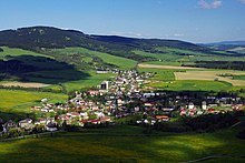
Červená Voda is an elongated row village in the valley of the Bílá Voda, a tributary of the Březná (Friesian). It is located in the Grulich Furche (Králická brázda) between the Eagle Mountains and the Hannsdorfer Uplands (Hanušovická vrchovina). The municipality is located on the main European watershed between the North Sea and the Black Sea. In the north, the area is drained by the upper reaches of the Silent Eagle into the river system of the Elbe , while the Březná carries its water over the March to the Danube . The municipality of Červená Voda is located in Moravian territory on the old border with Bohemia , the districts of Dolní and Horní Orlice used to belong to Bohemia.
To the northeast rise the Kamenáč (729 m) and the Jeřáb (1003 m), on the eastern edge of the village is the Křížová hora (Kreuzberg, 735 m) to which the Spálenisko (745 m) connects in the southeast. The ridge of the Bukovohorská hornatina with the Suchý vrch ( Dürrer Berg , 995 m) and the Buková hora (958 m) extends to the west .
The state road Silnice I / 11 leads through Červená Voda, which crosses the Červenovodské sedlo (red water saddle) west of the village in a sepertine section below the Prostřední vrch (871 m) near Orličky . In the village the state road Silnice I / 43 branches off to Králíky .
Neighboring towns are Dolní Orlice in the north, Šanov in the northeast, Tři Dvory and Moravský Karlov in the east, Písařov in the southeast, Mlýnice and Mlýnický Dvůr in the south, Čenkovice in the southwest, Orličky in the west and Horní Boříkovice and Dolní Bořestenkovice in the north-west.
history
Červená Voda was established in the 14th century and was first mentioned in a document as Malé Heroltice in 1481 when Albrecht the elder von Sternberg sold the Schildberg estate . There is evidence of a wooden church since 1539. In 1562 the glassmaker Georg Schürer built a glassworks in Mlýnice. In 1596 Ladislav Velen von Zerotein acquired the Schildberg estate together with the northern part of the Hohenstadt estate . He granted Georg Schürer's son Dominik Schürer von Waldheim the privilege to build a glassworks in Bílá Voda. Schürer von Waldheim had a castle with a courtyard and a brewery built in Mlýnice. After the battle of the White Mountain , Ladislav Velen von Zerotein lost all his possessions.
After Karl Eusebius of Liechtenstein had acquired the rule in 1624 , he joined it to Ruda nad Moravou , where he took his seat. In 1833 a wooden pilgrimage church was built on the Kreuzberg. In 1846 the place received market rights.
After the abolition of patrimonial Mährisch Rothwasser came to the political district Hohenstadt and the judicial district Schildberg in 1850 . Until the 19th century, the residents of the place lived primarily from agriculture, after 1850 the textile manufacturing took hold. In 1875 the first rural citizens' school in Moravia began teaching in Mährisch Rothwasser. With the completion of the Mährisch Schildberg – Grulich local railway , Mährisch Rothwasser received a railway connection in 1899. In 1910 there were several cotton spinning mills and a total of 44 textile producers in Mährisch Rothwasser. In 1919 a Czech minority school was established, which was closed in 1938. In 1929 an old Catholic church was built. In 1930 there were 2526 inhabitants in the market town, in 1939 there were 2326. After the Munich Agreement , Mährisch Rothwasser was attached to the German Empire and belonged to the Hohenstadt district from 1939 to 1945 . During the Second World War in Weißwasser, the "Friesewerk", a cover company of the Telefunken Society for wireless telegraphy in Berlin, produced components for radio control and radio measuring equipment for the Air Force. In 1944, a satellite camp of the Groß-Rosen concentration camp was set up in Weißwasser . Several hundred Jewish women from the Auschwitz concentration camp , mostly from Hungary, who worked in the frieze factory, were housed here in barracks . At the beginning of 1945 the number of concentration camp prisoners increased to around 650. The camp was liberated on May 8, 1945 when the Germans surrendered .
Between April 23 and October 25, 1946, the German population was deported. A total of 2,156 people were displaced in seven transports, after which 37 Germans were still living in Červená Voda. Moravian Czechs from the Tišňov area were settled in the village . A military training area for the Czechoslovak army was established on Křížová hora and was used by the Red Army from 1969 to 1990 . In 1960 the devastated pilgrimage church was torn down.
Since 1949, Šanov has been part of Červená Voda. In the course of the territorial reforms of 1960 Horní and Dolní Orlice, Bílá Voda, Moravský Karlov, Mlýnice and Mlýnický Dvůr were incorporated and the municipality was assigned to the Okres Ústí nad Orlicí . A lookout tower was inaugurated in 2006 on the Křížová hora.
Local division
The municipality of Červená Voda consists of the districts Bílá Voda ( Weißwasser ), Červená Voda ( Mährisch Rothwasser ), Dolní Orlice ( Nieder Erlitz ), Horní Orlice ( Ober Erlitz ), Mlýnice ( Lenzdorf ), Mlýnický Dvůr ( Hoflenz ), Moravský Karlov (Moravský Karlov ( Moravian) Karlsdorf ) and Šanov ( Schönau ) as well as the settlement Tři Dvory ( Dreihöfen ).
Attractions
- Church of the Apostle Matthew, built in 1686 in place of a previous building
- Rectory
- Trinity column, erected in 1715 as a plague column
- Chapel at Orlický les, consecrated in 2006
- Lookout tower on the Křížová hora
- Bunker lines of the Czechoslovak Wall between Šanov and Horní and Dolní Orlice
- Church of the Nativity of Our Lady in Mlýnický Dvůr, from 1575
- Castle of the Schürer von Waldheim in Mlýnický Dvůr, from the 17th century
- Church of St. Joseph in Moravský Karlov, built in 1792
- Little church in Šanov
- Chapel of St. Barbara in Horní Orlice
Sons and daughters of the church
- Karl Adolf Mayer (1889–1957), Austrian writer and honorary citizen of Graz
- Manfred Buder (* 1936), German ice hockey player
Web links
Individual evidence
- ↑ Český statistický úřad - The population of the Czech municipalities as of January 1, 2019 (PDF; 7.4 MiB)
- ↑ Klaus Christian Kasper (ed.): Women's labor camp Mährisch Weißwasser 1944/45. Forced labor for Telefunken. A survival station on the way from Auschwitz to Palestine with the Exodus. Memories, dates, pictures and documents. Self-published, Bonn-Oberkassel 2002, ISBN 3-930567-27-X .


