
Section fortification Kuhfels
| Section fortification Kuhfels | ||
|---|---|---|
 Section fortification Kuhfels - view of the rock spur from the southwest (August 2013) |
||
| Creation time : | Prehistory and early history, but possibly also medieval | |
| Castle type : | Höhenburg, spur location | |
| Conservation status: | Departed, received a stone wall | |
| Place: | Illschwang - Bachtesfeld - "Kuhfels" | |
| Geographical location | 49 ° 28 '56.1 " N , 11 ° 39' 3.5" E | |
| Height: | 568.3 m above sea level NN | |
|
||

The portion fixing Kuhfels is an Outbound pre- and early historical fastening system on a in a dry valley projecting Felssporn , the so-called Kuhfels . It is located around 885 meters south of the center of Bachtesfeld in the Upper Palatinate municipality of Illschwang in Bavaria , Germany . No historical or archaeological information is known about this section fortification, only a simple wall system has been preserved from the complex. The site is protected as a ground monument number D-3-6535-0058: section fortification of prehistoric times or the Middle Ages .
description
The spur castle is located on a north-east jutting into a dry valley 668.3 m above sea level. NN high rock spur. The system is cordoned off from the adjacent plateau on the southwest side by a naturally created railing channel 20 meters wide and two meters deep. This groove could have served as a neck ditch . The north-west side (cover picture) and the spur tip (picture 2) in the north-east are naturally very well protected by a steep, vertical drop of the rock faces several meters deep; the steeply sloping, but climbable south-east side is secured by a stone wall. This wall with a length of 20 meters is still 0.60 meters high and six meters wide (Fig. 3). It does not extend all the way from the spur tip along the southeast side and then bends 75 meters in front of the spur tip at a right angle to the northwest (Fig. 4). There it is still 0.80 meters high. The access to the complex could have been at this end of the rampart, which was completely leveled there by the construction of a mountain hut.
photos

Figure 2: View of the spur tip of the Kuhfelsen natural monument (August 2013)

Image 3: Wall on the northeast side, on the left the inner surface of the fortification (August 2013)
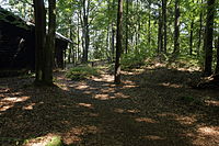
Photo 4: Bending rampart in the southeast, view from the foreground (August 2013)


literature
- Armin Stroh : The prehistoric and early historical monuments of the Upper Palatinate . (Material booklets on Bavarian prehistory, series B, volume 3). Verlag Michael Lassleben, Kallmünz 1975, ISBN 3-7847-5030-3 , pp. 82-83.
Web links
Individual evidence
- ↑ List of monuments for Illschwang (PDF) at the Bavarian State Office for Monument Preservation (PDF; 136 kB)
- ↑ Armin Stroh: The prehistoric and early historical site monuments of the Upper Palatinate. 1975, p. 82 f.


Castles: Schloss Adertshausen (sold) | Allersburg Castle (Alarasbach Castle) | Altenweiher Castle (exited) | Altneuhaus Castle (sold) | Ammerthal Castle | Auerbach Castle (exited) | Axtheid Castle | Castle Boden | Ebermannsdorf Castle | Emhof Palace | Eschenfelden Castle (exited) | Franziskaruhe Castle | Freihung Castle (exited) | Großalbershof Palace (exited) | Hannesreuth Palace | Haselmühl Castle | Haunritz Castle | Heringnohe Castle | Hirschau nursing home | Hammerschloss Hirschbach | Hirschwald hunting lodge (dismissed) | Högen Castle | Hohenburg Castle | Holnstein Castle | Castle mallet | Kalchsreuth Castle (exited) | Kirchenreinbach Castle | Koenigstein Castle | Kümmersbruck Castle | Langenbruck Castle (exited) | Leidersdorf Castle (exited) | Lower Lintach Castle | Upper Lintach Castle | Mendorferbuch Castle (exited) | Castle Moos | Neidstein Castle | Penkhof Palace | Pettenhof Palace (exited) | Upper Schmidmühlen Castle | Lower Schmidmühlen Castle | Steinling Castle | Sinnleithen Castle | Theuern hammer lock | Theuern Castle (exited) | Unterschnaittenbach Castle (exited) | Ursensollen Castle | Vilseck Castle | Hammerschloss Vilswörth | Weissenberg Castle | Winbuch Castle | Wolfsbach Castle | Brick's Castle | Zogenreuth Castle ( dismissed )
Castles and ruins: Allersburg Castle (dismissed) | Ammerthal Castle (exited) | Aschach castle ruins | Breitenstein castle ruins | Dagestein Castle | Eberburg Castle Ruins (Ebermannsdorf Castle) | Festenberg Castle (exited) | Freudenberg Castle (exited) | Burg Gernotenstein (Burg Huwenstein) (dismissed) | Haldenrode Castle (Burg Halwenrode) (dismissed) | Hartenfels Castle (exited) | Hauseck castle ruins | Heimhof Castle | Kastl Monastery Castle | Castle ruin Kürmreuth (Upper Castle) | Lichtenegg castle ruins | Neidstein Castle | Paulsdorf Castle (exited) | Castle ruin Pfaffenhofen (Schweppermannsburg) | Castle ruins Poppberg | Rieden Castle (exited) | Rosenberg Castle (exited) | Roßstein castle ruins | Rupprechtstein castle ruins | Scharfenberg Castle (exited) | Spitz Castle (exited) | Castle ruin Steinamwasser (Burg Strebenstein) | Sulzbach Castle | Werdenstein Castle (exited) | Zant castle ruins
Motten (all gone): Tower Hill The Tower (Berghausen Castle) | Höflas tower hill | Kellerhübl tower hill
Manor houses: Noble seat Hohenkemnath | Hammer seat Ranna
Castle stables (lost, unknown castles and fortifications): Burgstall Alte Bürg | Burgstall Altes Haus (Ratzenberg Castle) | Ammerthal Castle | Ringwall Archenleiten | Burgstall Bärenfall (Brennberg Castle?) | Burgstall Breitenthal (Tower in Weidenthal?) | Section fortification of Bürg | Ringwall Dürrling | Ringwall Ensdorf | Burgstall Ermhof | Ringwall Etsdorf | Castle stable Frohnberg | Burgstall Grünwald | Burgstall Gunzendorf | Burgstall Hagfelsen | Ringwall Hainsburg | Hainsburg section fortification | Burgstall Hausberg | Burgstall In the old house | Ringwall Johannisberg | Kalmusfels section fortification | Ringwall Kleiner Hubberg | Section fortification Kuhfels | Section fortification Kühlochberg | Burgstall Leherfels | Ringwall Leidersdorf | Burgstall Neumühle | Burgstall Schlossberg | Burgstall Schlössl | Burgstall Schmalnohe | Section fortification Schweinberg | Section fortification Spitziger Berg | Section fortification Steinberg | Ringwall Steinberg | Section fortification Sternsteinberg | Burgstall Theuern | Burgstall Trutziger Kaiser | Burgstall Uschlberg | Burgstall Wolfsbach | Ring wall Zant
Fortified churches: Fortified church Ehenfeld (St. Michael) | Fortified Church Gibbach (St. Martin) | Illschwang fortified church (St. Veit)