
Burgstall Hartenfels
| Burgstall Hartenfels | ||
|---|---|---|
 Burgstall Hartenfels - View of the Spornspitze with the lookout point |
||
| Creation time : | probably 13th century | |
| Castle type : | Höhenburg, spur location | |
| Conservation status: | Burgstall | |
| Standing position : | Reichsministerialenburg | |
| Place: | Neukirchen near Sulzbach-Rosenberg - "Hartenfels" | |
| Geographical location | 49 ° 31 '52.8 " N , 11 ° 38' 16" E | |
| Height: | 530.6 m above sea level NN | |
|
||

The Burgstall Hartenfels is the remainder of a high medieval aristocratic castle that once rose on an imposing rock spur. The Burgstall is located east of the parish village of Neukirchen bei Sulzbach-Rosenberg in the municipality of the same name in the Upper Palatinate district of Amberg-Sulzbach in Bavaria , Germany . No historical information is known about the castle, only two moats and a small remains of the wall have survived.
Geographical location

The place of the abandoned Spornburg is located in the Middle Franconian Jura , on a rock spur of the Great Hartenfelsen facing southwest at 530.6 m above sea level. NN height. It was about 80 meters above the valley. The spur drops vertically several meters on its northwest side and on the southern tip, and the southeast side also has a very steep slope, partly interspersed with rocks, so that only the north side, on which the spur emerges from the mountain, is protected had to.
The Burgstall is located about 700 meters east-northeast of the Protestant parish church of St. Peter and Paul in Neukirchen near Sulzbach-Rosenberg.
There are other former medieval castles in the vicinity: about 2500 meters to the southwest there is a castle stables on the eastern part of the Buchenberg near Ermhof , at the same distance to the west is Neidstein Castle with the castle ruins of the same name immediately behind. A little further are the Rupprechtstein castles , today only a ruin with very few remains, and Werdenstein , which is only a castle stable. To the north is the Holnstein Castle , which used to be a castle.
history
The castle was probably built during the 13th century by the Lords of Neidstein, but there is no mention of the castle itself. Only in a document dated February 21, 1268 is it indirectly mentioned in the name of Heinrich von Hertenvels ( = Hartenfels) called. This document says that the deceased Heinrich is buried in the church in Eschenbach . This document also shows that Heinrich had two brothers, the Reich ministerial "Rupert von Hertenstein" ( Hartenstein ) and "Rupert von Neidstein ". Since the Hartenfelser, like the Hartensteiner, were related to the Neidsteiner family, they too probably had the status of Reichsministeriales.
In addition to the high medieval fortifications on the Hartenfels, there are also the remains of a prehistoric complex in the same place. A longer piece of rampart, about half a meter high, has been preserved from it, which arches around the mountain spur outside the moat of the medieval castle and thus cordoned it off.
Today the site of the former castle is completely overgrown with forest , only two moats and remains of the foundation wall of the former curtain wall have survived. A hiking trail from Neukirchen bei Sulzbach-Rosenberg leads to the freely accessible castle stables; thanks to a bench that has been set up, it now serves as a resting place and a lookout point. The vertical or slightly overhanging rock walls serve as a climbing wall.
The ground monument registered by the Bavarian State Office for the Preservation of Monuments as "Hartenfels Medieval Castle Stables" has the monument number D-3-6435-0036.
description
The former hilltop castle was once divided into two areas, a bailey at the transition from the spur to the flat summit area or the plateau of the Hartenfels (Fig. 1), and a main castle at the rocky tip of the mountain spur, which is naturally best protected Place (picture 3).
The outer bailey was protected by a ditch two meters deep and about ten meters wide, which arched from the eastern edge of the slope to the western edge (Fig. 2 and 4). The bottom of this neck ditch sinks from east to west by several meters, and there flows into a naturally created railing channel. Overburden mounds at the ends of the trench as a sign of artificial origin cannot be seen, but the trench has certainly been dug by human hands. On the outside of the trench there is a three-meter-wide rampart, which begins today on the east side of the trench and gradually becomes flatter in a westerly direction after about half of the distance in the terrain. Outside of this wall, in the direction of the plateau, lies the prehistoric wall section mentioned above. The outer bailey is limited, except to the north towards the neck ditch, on almost all sides by vertical cliffs, which are only a few meters. The adjoining mountain slopes drop very steeply, partly interspersed with rocky edges, to the valley. Its demarcation is only unclear on the east-northeast side, as it is not directly protected by steep slopes or rocks here, but is followed by a basin. The area of the outer bailey is of a very irregular shape, as it was adapted to the rocky terrain between the plateau and the rocky spur, and the area of the outer bailey drops a few meters from the neck ditch to the main castle. Since it was so easily attacked from the plateau, it had to be protected on its northeast side by a strong wall, from which a wall 4.50 meters wide and one meter high has been preserved. Approximately in the middle of this rampart, a 3.80-meter-wide interruption suggests the earlier access to the castle, even today one enters the grounds of the castle stable at this point. To the south-west of the outer bailey is a larger rock eight meters long by about five meters, but it was still included in the outer bailey, and remains of masonry can still be found on its surface. Traces of further development can no longer be seen from the outer bailey.
The outer bailey ends in the south at a natural cut in the terrain, which at the deepest point shows a section ditch carved out of the rock (Fig. 5). This ditch drops off about two meters to the outer bailey, the main castle rises four meters very steeply from the bottom of this ditch. A ledge to the east of today's entrance to the main castle, about halfway up the steep slope, probably marked the earlier access to the main castle (Fig. 6).
The main castle has a trapezoidal area about 50 meters long and 25 meters wide. On its west and south sides it is well protected by the vertical drop of the rocks by a few meters, and the steeply sloping eastern slope also offered sufficient protection. The north side was also quite safe due to vertical rocks and steep slopes. On this side, the remains of the foundation wall of the presumed ring wall of the castle are still preserved, but they only appear as a flat wall (Fig. 7). This wall stretches 16 meters along the north side, then turns to the north-east corner of the main castle in a southerly direction and there runs another five meters along the edge of the slope. Only at the northwest corner is a small remnant of the wall visible above ground (Fig. 8). There are no more traces of construction on the flat surface of the main castle, next to an almost square pit in the middle of the area. This pit measures 4 by 3.50 meters and could be the rest of a cistern or a basement room (Fig. 9). Numerous ceramic shards were found on the southern edge of the rock spur, so that one can probably assume a kitchen building there.
There are also twelve steps carved out of the rock, which lead down from the castle area over the vertical rock slope (Fig. 10). It is unknown whether they belonged to the former castle complex, but they were probably only created later on a hiking trail that leads through the Burgstall grounds.
photos


Image 3: Southern tip of the rock spur

Image 4: View into the neck ditch, on the left the wall, possibly a former shield wall, the outer bailey
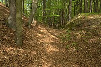
Photo 5: View into the trench section, the main castle on the left
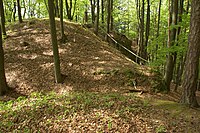
Image 6: Possible location of the ascent to the main castle, today's ascent in the background

Photo 7: Wall on the north side of the main castle, the rest of the curtain wall
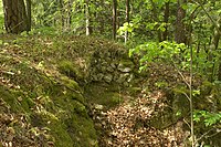
Photo 8: The last visible remains of the wall around the main castle

Photo 9: Hollow in the main castle, possibly the place of the cistern or a building

Photo 10: Rock steps on the south side of the main castle


literature
- Stefan Helml: Castles and palaces in the Amberg-Sulzbach district . Druckhaus Oberpfalz, Amberg 1991, pp. 80-81.
- Hellmut Kunstmann : Burgstall Hartenfels . In: Communications of the Altnürnberger Landschaft . Published by the Altnürnberger Landschaft eV, December 1953, 2nd year, issue 3, pp. 7–9.
- Armin Stroh : The prehistoric and early historical monuments of the Upper Palatinate . (Material booklets on Bavarian prehistory, series B, volume 3). Verlag Michael Lassleben, Kallmünz 1975, ISBN 3-7847-5030-3 , p. 121.
Web links
References and comments
- ^ Location of the Burgstall in the Bavarian Monument Atlas
- ^ The Burgstall on the website of the Bavarian State Office for Monument Preservation
- ↑ The castle and the previous castle on the side of the Bavarian State Office for Monument Preservation
- ^ Stefan Helml: Castles and palaces in the Amberg-Sulzbach district , p. 80
- ^ Source history with a few exceptions: Hellmut Kunstmann: Burgstall Hartenfels . In: Mitteilungen der Altnürnberger Landschaft , p. 9
- ↑ According to Kunstmann, this was a shield wall
- ↑ Source description: Hellmut Kunstmann: Burgstall Hartenfels . In: Mitteilungen der Altnürnberger Landschaft , p. 7ff.
- ↑ Kunstmann does not mention these stages in his otherwise very detailed essay from 1953, so that one can assume that they did not exist at the time


Castles: Schloss Adertshausen (sold) | Allersburg Castle (Alarasbach Castle) | Altenweiher Castle (exited) | Altneuhaus Castle (sold) | Ammerthal Castle | Auerbach Castle (exited) | Axtheid Castle | Castle Boden | Ebermannsdorf Castle | Emhof Palace | Eschenfelden Castle (exited) | Franziskaruhe Castle | Freihung Castle (exited) | Großalbershof Palace (exited) | Hannesreuth Palace | Haselmühl Castle | Haunritz Castle | Heringnohe Castle | Hirschau nursing home | Hammerschloss Hirschbach | Hirschwald hunting lodge (dismissed) | Högen Castle | Hohenburg Castle | Holnstein Castle | Castle mallet | Kalchsreuth Castle (exited) | Kirchenreinbach Castle | Koenigstein Castle | Kümmersbruck Castle | Langenbruck Castle (exited) | Leidersdorf Castle (exited) | Lower Lintach Castle | Upper Lintach Castle | Mendorferbuch Castle (exited) | Castle Moos | Neidstein Castle | Penkhof Palace | Pettenhof Palace (exited) | Upper Schmidmühlen Castle | Lower Schmidmühlen Castle | Steinling Castle | Sinnleithen Castle | Theuern hammer lock | Theuern Castle (exited) | Unterschnaittenbach Castle (exited) | Ursensollen Castle | Vilseck Castle | Hammerschloss Vilswörth | Weissenberg Castle | Winbuch Castle | Wolfsbach Castle | Brick's Castle | Zogenreuth Castle ( dismissed )
Castles and ruins: Allersburg Castle (dismissed) | Ammerthal Castle (exited) | Aschach castle ruins | Breitenstein castle ruins | Dagestein Castle | Eberburg Castle Ruins (Ebermannsdorf Castle) | Festenberg Castle (exited) | Freudenberg Castle (exited) | Burg Gernotenstein (Burg Huwenstein) (dismissed) | Haldenrode Castle (Burg Halwenrode) (dismissed) | Hartenfels Castle (exited) | Hauseck castle ruins | Heimhof Castle | Kastl Monastery Castle | Castle ruin Kürmreuth (Upper Castle) | Lichtenegg castle ruins | Neidstein Castle | Paulsdorf Castle (exited) | Castle ruin Pfaffenhofen (Schweppermannsburg) | Castle ruins Poppberg | Rieden Castle (exited) | Rosenberg Castle (exited) | Roßstein castle ruins | Rupprechtstein castle ruins | Scharfenberg Castle (exited) | Spitz Castle (exited) | Castle ruin Steinamwasser (Burg Strebenstein) | Sulzbach Castle | Werdenstein Castle (exited) | Zant castle ruins
Motten (all gone): Tower Hill The Tower (Berghausen Castle) | Höflas tower hill | Kellerhübl tower hill
Manor houses: Noble seat Hohenkemnath | Hammer seat Ranna
Castle stables (lost, unknown castles and fortifications): Burgstall Alte Bürg | Burgstall Altes Haus (Ratzenberg Castle) | Ammerthal Castle | Ringwall Archenleiten | Burgstall Bärenfall (Brennberg Castle?) | Burgstall Breitenthal (Tower in Weidenthal?) | Section fortification of Bürg | Ringwall Dürrling | Ringwall Ensdorf | Burgstall Ermhof | Ringwall Etsdorf | Castle stable Frohnberg | Burgstall Grünwald | Burgstall Gunzendorf | Burgstall Hagfelsen | Ringwall Hainsburg | Hainsburg section fortification | Burgstall Hausberg | Burgstall In the old house | Ringwall Johannisberg | Kalmusfels section fortification | Ringwall Kleiner Hubberg | Section fortification Kuhfels | Section fortification Kühlochberg | Burgstall Leherfels | Ringwall Leidersdorf | Burgstall Neumühle | Burgstall Schlossberg | Burgstall Schlössl | Burgstall Schmalnohe | Section fortification Schweinberg | Section fortification Spitziger Berg | Section fortification Steinberg | Ringwall Steinberg | Section fortification Sternsteinberg | Burgstall Theuern | Burgstall Trutziger Kaiser | Burgstall Uschlberg | Burgstall Wolfsbach | Ring wall Zant
Fortified churches: Fortified church Ehenfeld (St. Michael) | Fortified Church Gibbach (St. Martin) | Illschwang fortified church (St. Veit)