Poppberg castle ruins
| Poppberg castle ruins | ||
|---|---|---|
|
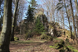
Castle ruins Poppberg - View of the circular wall tower on a high rock cone from the west |
||
| Creation time : | probably during the 13th century | |
| Castle type : | Höhenburg, summit location | |
| Conservation status: | Ruins, the substance of which is partially threatened with demolition | |
| Standing position : | Counts, dukes | |
| Construction: | Quarry stone masonry, partially with corner hump ashlar | |
| Place: | Birgland- Poppberg | |
| Geographical location | 49 ° 24 '48.9 " N , 11 ° 35' 7" E | |
| Height: | 652.6 m above sea level NN | |
|
|
||
The castle ruins Poppberg is a former high to late medieval aristocratic castle near the village of Poppberg in the municipality of Birgland in the Upper Palatinate district of Amberg-Sulzbach in Bavaria .
The castle ruins are freely accessible at all times.
Geographical location
The ruin of the summit castle is located on the rocky summit of 652.6 m above sea level. NN high Poppberg in the Franconian Alb , about 600 meters west-north-west of the church of the village of the same name Poppberg in the municipality of Birgland and about 20 kilometers west of the city of Amberg .
In the immediate vicinity is the Leherfels Castle stable on the Leherberg. Three kilometers east-northeast is the Hagfelsen castle stable near the village of Burkartshof, which may have been a predecessor of Poppberg Castle. The former Habsberg Castle , today a castle stable on which the pilgrimage church of the Assumption of the Virgin Mary stands, is within sight .
history
The two-part hilltop castle was probably built in the 13th century by the Counts of Sulzbach . It was mentioned in the ownership of Emperor Charles IV from 1353 to 1373 . After the castle fell to the Margrave Otto von Brandenburg , it came in 1379 to the Bavarian dukes Johann and Stephan , who in 1395 passed it to Count Palatine Ruprecht III. sold. In 1505 the castle was incorporated into the Duchy of Sulzbach and the land was sold to farmers in 1550. After the castle fell into disrepair, the ruins came to the Bavarian state in 1791 and are now privately owned.
Building description
The former Poppberg Castle stood on the highest point of the free-standing conical Poppberg, which drops only moderately steeply on all sides about 60 meters. The castle was built on a rocky plateau on the summit. Around the castle ruins, the slopes of the Poppberg are heavily riddled with rocks, so that an approach was difficult despite the only moderate ascent.
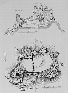
The plateau has an area of about 75 × 45 meters and an approximately rectangular floor plan. The castle complex consisted of a main castle and a bailey-like outer castle courtyard, which were surrounded by a common circular wall adapted to the rocky step of the plateau edge . The castle path came from the west, led past the south-west corner of the castle complex, on which a wall tower stood, and ended roughly in the middle of the south side in the former castle gate . The gate led into the outer courtyard on the east side of the complex, of which only the not yet secured and therefore threatened remains of the curtain wall have been preserved. Uneven terrain could be due to former buildings that leaned against the curtain wall.
The area of the main castle, which was only separated by a simple wall, adjoined the outer castle courtyard immediately to the west. In the northern part of the main castle is still very well preserved was Palas . The main building had a rectangular floor plan and was about 25 meters long and 12 meters wide. Like the rest of the castle complex, it consisted of roughly worked quarry stone masonry. Only in the southeast corner of the building were more carefully worked humpback blocks used. They were broken out to a height of about three meters and presumably used to construct buildings in the area. It is not known whether humpback cubes were also used in the remaining corners, as the outer walls are missing on the west and north sides. The main building probably had a tower-like shape. Three floors are still preserved, at least one more is suspected. Half of the access is buried and formerly led to a basement, which was followed by an unexposed mezzanine. The actual living area was on the third floor of the hall and had three entrances. On the southern long side towards the castle area was probably the main entrance, which was accessible via a staircase. At the south-west and north-east corner, two further entrances led to the battlements of the circular wall attached to the palace. There are window openings on this floor.
On the southwest side, a tower had been built on a sharp rock, the highest point of the castle. This tower is not a dungeon to see its small dimensions speak against it. However, it was cleverly integrated into the castle complex, from which a large part of the castle path and the gate could be viewed and painted. The inner area of the castle could also be partially overlooked from there. The tower had a square floor plan and protruded from the curtain wall in full width on the south and west sides. Its south and east sides are still preserved, on the west side almost all of the outer masonry is missing, the north side is completely missing. Its top, about four meters high, is now covered with bricks. During the Second World War there was an "air station" manned by flak soldiers. Together with other "air watchdogs" they observed air traffic around Nuremberg and reported every aircraft to the headquarters there. The observation is said to have already taken place during the "Nazi Party Rallies" before the war.
literature
- Ursula Pfistermeister : Castles of the Upper Palatinate . Friedrich Pustet Verlag, Regensburg 1974, ISBN 3-7917-0394-3 , p. 93.
- Stefan Helml: Castles and palaces in the Amberg-Sulzbach district . Druckhaus Oberpfalz, Amberg 1991, pp. 173–177.
- Karl Wächter, Günter Moser: On the trail of knights and nobles in the Amberg-Sulzbach district - castles, palaces, noble residences, hammer estates . Buch & Kunstverlag Oberpfalz, Amberg 1992, ISBN 3-924350-26-4 , pp. 42-43.
- Andreas Boos : Birgland-Poppberg: Poppberg castle ruins . In: Silvia Codreanu-Windauer , Uta Kirpal, Gabriele Raßhofer (eds.): Guide to archaeological monuments in Germany, Volume 44: Amberg and the land an Naab and Vils . Theiss Verlag, Stuttgart 2004, ISBN 3-8062-1877-3 , pp. 153-155.
- Herbert Rädle, Günther Enzmann: Castles and fortress stables in the Neumarkt district . Brönner and Daentler, Eichstätt o. J., ISBN 3-920142-14-4 , pp. 90-93.
Web links
- Burgruine Poppberg on the Burgenwelt.de page
- Castle ruins Poppberg on Burgseite.de
Individual evidence
- ^ Topographic map 1: 25000, sheet 6535 Alfeld
- ↑ Location of the castle ruins on the map of the Bavaria Viewer ( Memento of the original from September 24, 2015 in the Internet Archive ) Info: The archive link was automatically inserted and not yet checked. Please check the original and archive link according to the instructions and then remove this notice.
- ^ Karlburg-Roßtal-Oberammerthal: Studies on early medieval castle building in Northern Bavaria; Excavations by the Bavarian State Office for Monument Preservation
- ↑ Ferdinand Leja: Forgotten castle stables on the Franconian Jura - or where was the "Ratzenberg" castle? In: Contributions to archeology in the Upper Palatinate and Regensburg, Volume 5 , Verlag Dr. Faustus, Büchenbach 2002, ISSN 1617-4461 , pp. 256ff.
- ^ Castles and palaces in the Neumarkt district, A guide to historical sites, pp. 39–40.


