
Hagfelsen Castle Stables
| Hagfelsen Castle Stables | ||
|---|---|---|
 Burgstall Hagfelsen - View of the gate gap of the ring wall |
||
| Creation time : | middle Ages | |
| Castle type : | Höhenburg, summit location | |
| Conservation status: | Burgstall | |
| Standing position : | Presumably Ministerialenburg | |
| Place: | Birgland - Burkartshof - "Hagfelsen" | |
| Geographical location | 49 ° 25 '21.3 " N , 11 ° 37' 32.9" E | |
| Height: | 630.5 m above sea level NN | |
|
||

The Hagfelsen castle stable is the remainder of a high medieval aristocratic castle that once stood on a rocky ridge. The Burgstall is located west of the wasteland Burkartshof in the municipality of Birgland in the Upper Palatinate district of Amberg-Sulzbach in Bavaria , Germany .
No historical information is known of the castle, which may have been a predecessor of the nearby Poppberg Castle. Only a ring wall has survived from it , but it dates from prehistoric times and was included in the construction of the Middle Ages.
Geographical location
The castle stable of the Gipfelburg is located about 260 meters west-southwest of the Burkartshof and about 6 kilometers east of the Evangelical Lutheran parish church of St. Bartholomew in Alfeld . The site of the former small castle is located in the center of the central Franconian Jura , at 630.5 m above sea level. NN height on the summit of the Hagfelsens, a small rock ridge that extends from northwest to southeast. The slopes of the completely forested mountain drop only slightly steeply on all sides about 30 meters in altitude . In the north and in the east the mountain merges into the surrounding dry valleys, through which two local roads run. To the west, after a hollow in the terrain, the also wooded Hirschberg joins; to the south, beyond the route of the A 6, there is also a wooded ridge.
There are other former medieval castles in the vicinity, just three kilometers to the southwest is the Poppberg castle ruins , of which some remains of walls and buildings have been preserved and which may have been a successor to the castle on the Hagfelsen. A little further in this direction is the Burgstall Leherfels at 630.1 m above sea level. NN high Leherberg, only a quarter-round ditch with an outer wall is visible from the castle stable. To the north lies the Lichtenegg castle ruins .
history
The history of the castle on the Hagfelsen is still completely hidden in the darkness of history, there are no known documents that refer to this castle. Thus, the builder and the time of construction of the complex, who sat on it and why it was abandoned or destroyed are unknown. After Ferdinand Leja they belonged to a castle type with the old Postal Bürg , the Postal In the old house and the castle Ratzenberg - even the Postal on the Leherberg you can probably count on these systems - often in the area occurs. With the exception of the old burgs, these complexes were rather small castles, most likely tower castles , which were located on structurally less suitable cliffs and probably from the 12th / 13th centuries. Century. The owners were probably the lower nobility Ministeriale or the local nobility.
The castle on the Hagfelsen was used until the 13th and 14th centuries. Century, as shown by the finds of ceramic shards in the museums of Regensburg and Sulzbach. According to Leja, it could have been a predecessor of the nearby Poppberg Castle, which was first mentioned in 1373 and was probably built not much earlier, probably in the 13th century. The castle did not have a keep , and the building findings do not suggest that it was built earlier.
The reason for the construction of the castle was the monitoring of a section of a nearby old road , the Hochstrasse and Eisenstrasse , which ran from Poppberg via Hirschricht roughly on the route of the A 6 .
The south-western side of the rocky reef is surrounded by an arched stone wall that dates back to the Hallstatt period , as finds have shown. It is possible that the castle was built at this point because of the existing wall in order to save the earthworks. The rock was also settled earlier, the Bavarian State Office for Monument Preservation describes the site as a hilltop settlement from the Urnfield period .
Today the place of the former castle is completely overgrown with forest , only the ring wall is preserved. A hiking trail leads past the freely accessible Burgstall. The vertical or slightly overhanging rock walls serve as a climbing wall.
The ground monument recorded by the Bavarian State Office for the Preservation of Monuments as "Medieval castle stables, ramparts of prehistoric and prehistoric times, hilltop settlement of the Urnfield period" bears monument number D-3-6535-0012.
description
The former hilltop castle was once divided into two areas, a bailey , located at the southwestern foot of the rocky ridge within the ring wall, and a main castle or upper castle at the rocky tip of the ridge, at the most naturally protected area.
The area of the outer bailey was curved around the rock ridge and is bounded by a prehistoric stone wall (Fig. 1). This 180 meter long wall starts at the northwest end of the ridge that extends from northwest to southeast and after a few meters bends sharply to the west and then to the southwest (Fig. 2). This is followed by an interruption of the wall, the earlier access to the castle (title picture). The wall then continues in an arc shape with a maximum distance of up to 40 meters to the rocks to the south and east (Fig. 3) and reaches the southeast end of the ridge. The northern part of the wall in the area of the gate gap is significantly higher than the opposite end; it was probably reinforced a little when the castle was built in the Middle Ages. The area of the outer bailey rises more and more towards the ridge and only offered enough space for buildings directly on the wall and at the southeast end. At this end there is also a hollow in the floor, possibly the site of a building.
The upper castle stood at 630.5 m above sea level. NN height on an approximately triangular summit surface with the dimensions of 15 × 15 meters (Fig. 4). This only largely flat and stepped surface was roughly in the middle of the ridge, the rest of the rock ridge, about 130 meters in length, offered little space for further buildings. To the north-east it drops vertically up to 20 meters (Fig. 5), to the south-east there is a high rock step, only to the north-west is a lower-lying area measuring around 20 by 3 meters, which, however, was probably not built up because of its steep incline. There are no traces of development. The stairs to the upper castle led over a ramp on the rock ridge to a small leveled area in the upper third of the rock. There was possibly a gate building there (Fig. 6).
photos
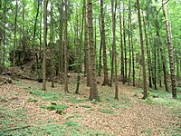
Image 1: View of the area of the outer castle, left and in the background the cliffs of the upper castle
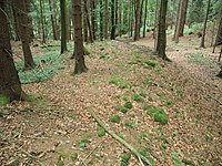
Photo 2: Northern part of the ring wall, in the background the gate gap, on the left the castle area
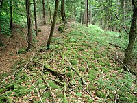
Photo 3: Eastern part of the ring wall, on the left the outer bailey

Image 4: Surface of the castle rock
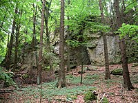
Photo 5: Castle rock from the northeast

Image 6: Paragraph at the stairway to the upper castle, possible location of a gate, in the background the further ascent to the upper castle


literature
- Ferdinand Leja: Forgotten castle stables on the Franconian Jura - or where was the “Ratzenberg” castle? In: Contributions to archeology in the Upper Palatinate and Regensburg, Volume 5 . Publishing house Dr. Faustus, Büchenbach 2002, ISSN 1617-4461 , pp. 256-260.
- Armin Stroh : The prehistoric and early historical monuments of the Upper Palatinate . (Material booklets on Bavarian prehistory, series B, volume 3). Verlag Michael Lassleben, Kallmünz 1975, ISBN 3-7847-5030-3 , pp. 121-122.
References and comments
- ^ Location of the Burgstall in the Bavaria Atlas, here referred to as an early historical rampart
- ↑ http://geodaten.bayern.de/tomcat/viewerServlets/mpsAndDbQuery?data=
- ↑ Source history: Ferdinand Leja: Forgotten castle stables on the Franconian Jura - or where was the "Ratzenberg" castle? In: Contributions to archeology in the Upper Palatinate and Regensburg, Volume 5 , pp. 256ff.
- ↑ http://geodaten.bayern.de/tomcat/viewerServlets/mpsAndDbQuery?data=


Castles: Schloss Adertshausen (sold) | Allersburg Castle (Alarasbach Castle) | Altenweiher Castle (exited) | Altneuhaus Castle (sold) | Ammerthal Castle | Auerbach Castle (exited) | Axtheid Castle | Castle Boden | Ebermannsdorf Castle | Emhof Palace | Eschenfelden Castle (exited) | Franziskaruhe Castle | Freihung Castle (exited) | Großalbershof Palace (exited) | Hannesreuth Palace | Haselmühl Castle | Haunritz Castle | Heringnohe Castle | Hirschau nursing home | Hammerschloss Hirschbach | Hirschwald hunting lodge (dismissed) | Högen Castle | Hohenburg Castle | Holnstein Castle | Castle mallet | Kalchsreuth Castle (exited) | Kirchenreinbach Castle | Koenigstein Castle | Kümmersbruck Castle | Langenbruck Castle (exited) | Leidersdorf Castle (exited) | Lower Lintach Castle | Upper Lintach Castle | Mendorferbuch Castle (exited) | Castle Moos | Neidstein Castle | Penkhof Palace | Pettenhof Palace (exited) | Upper Schmidmühlen Castle | Lower Schmidmühlen Castle | Steinling Castle | Sinnleithen Castle | Theuern hammer lock | Theuern Castle (exited) | Unterschnaittenbach Castle (exited) | Ursensollen Castle | Vilseck Castle | Hammerschloss Vilswörth | Weissenberg Castle | Winbuch Castle | Wolfsbach Castle | Brick's Castle | Zogenreuth Castle ( dismissed )
Castles and ruins: Allersburg Castle (dismissed) | Ammerthal Castle (exited) | Aschach castle ruins | Breitenstein castle ruins | Dagestein Castle | Eberburg Castle Ruins (Ebermannsdorf Castle) | Festenberg Castle (exited) | Freudenberg Castle (exited) | Burg Gernotenstein (Burg Huwenstein) (dismissed) | Haldenrode Castle (Burg Halwenrode) (dismissed) | Hartenfels Castle (exited) | Hauseck castle ruins | Heimhof Castle | Kastl Monastery Castle | Castle ruin Kürmreuth (Upper Castle) | Lichtenegg castle ruins | Neidstein Castle | Paulsdorf Castle (exited) | Castle ruin Pfaffenhofen (Schweppermannsburg) | Castle ruins Poppberg | Rieden Castle (exited) | Rosenberg Castle (exited) | Roßstein castle ruins | Rupprechtstein castle ruins | Scharfenberg Castle (exited) | Spitz Castle (exited) | Castle ruin Steinamwasser (Burg Strebenstein) | Sulzbach Castle | Werdenstein Castle (exited) | Zant castle ruins
Motten (all gone): Tower Hill The Tower (Berghausen Castle) | Höflas tower hill | Kellerhübl tower hill
Manor houses: Noble seat Hohenkemnath | Hammer seat Ranna
Castle stables (lost, unknown castles and fortifications): Burgstall Alte Bürg | Burgstall Altes Haus (Ratzenberg Castle) | Ammerthal Castle | Ringwall Archenleiten | Burgstall Bärenfall (Brennberg Castle?) | Burgstall Breitenthal (Tower in Weidenthal?) | Section fortification of Bürg | Ringwall Dürrling | Ringwall Ensdorf | Burgstall Ermhof | Ringwall Etsdorf | Castle stable Frohnberg | Burgstall Grünwald | Burgstall Gunzendorf | Burgstall Hagfelsen | Ringwall Hainsburg | Hainsburg section fortification | Burgstall Hausberg | Burgstall In the old house | Ringwall Johannisberg | Kalmusfels section fortification | Ringwall Kleiner Hubberg | Section fortification Kuhfels | Section fortification Kühlochberg | Burgstall Leherfels | Ringwall Leidersdorf | Burgstall Neumühle | Burgstall Schlossberg | Burgstall Schlössl | Burgstall Schmalnohe | Section fortification Schweinberg | Section fortification Spitziger Berg | Section fortification Steinberg | Ringwall Steinberg | Section fortification Sternsteinberg | Burgstall Theuern | Burgstall Trutziger Kaiser | Burgstall Uschlberg | Burgstall Wolfsbach | Ring wall Zant
Fortified churches: Fortified church Ehenfeld (St. Michael) | Fortified Church Gibbach (St. Martin) | Illschwang fortified church (St. Veit)