Burgstall Leherfels
| Burgstall Leherfels | ||
|---|---|---|
|
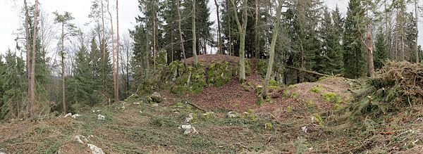
Burgstall Leherfels - View from the west of the rocky dome (June 2012) |
||
| Creation time : | Medieval | |
| Castle type : | Höhenburg, summit location | |
| Conservation status: | Castle stable, wall and moat remains | |
| Place: | Birgland - Ödamershüll - "Leherberg" | |
| Geographical location | 49 ° 25 '13.4 " N , 11 ° 34' 30.3" E | |
| Height: | 634 m above sea level NHN | |
|
|
||
The Postal Leherfels is an Outbound hilltop castle on the north-east of Leherberg Ödamershüll , in the municipality of Birgland in Amberg-Sulzbach in Bavaria . There is no information about the history of this fortification, it is roughly dated to the Middle Ages . Only a ring moat with an outer wall remains of this castle complex. Today the Burgstall is registered as a floor monument D-3-6535-0034 "Medieval Burgstall" by the Bavarian State Office for Monument Preservation .
description
The fortification was on the 634 m above sea level. NHN high summit of the conical Leherberg, which has formed as a flattened cliff. This summit drops steeply a few meters to the northeast , on the other sides it is protected by two to three meters high and vertically sloping rock walls (picture). Traces of former buildings can no longer be seen. The south and south-west side of the dome was protected by a seven-meter-wide ring trench carved out of the rock with an outer wall made of stone rubble. Local historian Anton Dollacker sees a collapsed dry stone wall in this wall . In the west, a small flat area adjoins the ditch, it is about one meter lower than the adjacent area. Their artificial or natural origin is unclear.
literature
- Sixtus Lampl (arrangement): Monuments in Bavaria - ensembles, architectural monuments, archaeological site monuments : Volume III. Upper Palatinate . Bavarian State Office for Monument Preservation (Ed.), R. Oldenbourg Verlag , 1985.
- Armin Stroh : The prehistoric and early historical monuments of the Upper Palatinate . (Material booklets on Bavarian prehistory, series B, volume 3). Verlag Michael Lassleben, Kallmünz 1975, ISBN 3-7847-5030-3 , p. 122.
Web links
- Entry on Leherfels in the private database "Alle Burgen".
Individual evidence
- ↑ Location of the Burgstall in the Bavaria Atlas (here referred to as an early historical rampart)
- ^ Bavarian State Office for Monument Preservation
- ↑ List of monuments for Birgland (PDF) at the Bavarian State Office for Monument Preservation (PDF; 133 kB)
- ↑ Source description: Armin Stroh: The prehistoric and prehistoric terrain monuments of the Upper Palatinate , p. 122.


