Adelmannsfelden
| coat of arms | Germany map | |
|---|---|---|

|
Coordinates: 48 ° 57 ' N , 10 ° 0' E |
|
| Basic data | ||
| State : | Baden-Württemberg | |
| Administrative region : | Stuttgart | |
| County : | Ostalbkreis | |
| Management Community : | Ellwangen (Jagst) | |
| Height : | 471 m above sea level NHN | |
| Area : | 22.9 km 2 | |
| Residents: | 1688 (December 31, 2018) | |
| Population density : | 74 inhabitants per km 2 | |
| Postcodes : | 73486, 73453 | |
| Area code : | 07963 | |
| License plate : | AA, GD | |
| Community key : | 08 1 36 003 | |
| LOCODE : | DE AD5 | |
| Community structure: | 4 districts | |
| Address of the municipal administration: |
Hauptstrasse 71 73486 Adelmannsfelden |
|
| Website : | ||
| Mayor : | Edwin Hahn ( CDU ) | |
| Location of the municipality of Adelmannsfelden in the Ostalb district | ||
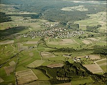
Adelmannsfelden is a municipality in the Ostalbkreis in Baden-Württemberg ( Germany ). The community is a member of the agreed administrative community of the city of Ellwangen (Jagst) .
geography
Adelmannsfelden located in the countryside Ellwanger mountains in natural area Swabian-Franconian Forest .
Community structure
The municipality of Adelmannsfelden includes 18 villages, hamlets, farms and houses: In addition to the villages of Adelmannsfelden, Bühler, Haid and Stöcken, these are the hamlets of Mittelwald, Ottenhof and Vorderwald, the Dollishäusle, Eichhorn, Kuderberg, Mäder, Metzelgehren, oil mill, paper mill and patrician house and Wendenhof as well as the Sägmühle and Schleifhäusle houses. Furthermore, the abandoned farms of Altenwind, Kunhof, Härzern, Limperg, Scheytenmühle, Breitengehren, Finkenhaus, Vorhardsweiler, Herzert, Herrenmühle and Rot diu Mul were located on today's markings of Adelmannsfelden.
Division of space

According to data from the State Statistical Office , as of 2014.
Neighboring communities
The community borders in the northeast on Rosenberg , in the east on Neuler , in the south on Abtsgmünd (all Ostalbkreis), in the west on Sulzbach-Laufen and in the north on Bühlerzell (both district Schwäbisch Hall ).
history
The place was first mentioned in a document around 1118 in the Ellwanger annals. During this time, the castle was built, in the place of which is the Adelmannsfelden Castle, which is still inhabited today by descendants of the Adelmann von Adelmannsfelden family. Spiritual and secular rulers changed several times until the village became part of the Kingdom of Württemberg in 1806 . There it belonged to the Aalen District Office , from which the Aalen district emerged in 1938 . With its dissolution, Adelmannsfelden came to the newly formed Ostalbkreis in the course of the district reform in 1973 .
As part of the 900th anniversary of the congregation, the men's European fistball championship with ten participating nations and over 7000 spectators took place on the sports grounds in Adelmannsfelden from August 24th to 26th, 2018 . The organizer was the local gymnastics and sports club Adelmannsfelden.
Religions
The Reformation was introduced in Adelmannsfelden in 1561. Since then, the place has been predominantly evangelical . The Protestant parish of Adelmannsfelden belongs to the church district of Aalen . The Catholic residents - after the Second World War many Catholic refugees and displaced persons came to Adelmannsfelden - have a church in Ottenhof and chapels in Bühler and Stöcken and are spiritually cared for from Abtsgmünd.
politics
Municipal council
The Adelmannsfelden municipal council has ten members, eight men and two women. He was elected on May 25, 2014. The turnout of 63.3% was 3 percentage points lower than in the 2009 municipal council election.
mayor
Mayor of Adelmannsfelden is Edwin Hahn (CDU). He was re-elected for the third term in July 2011.
coat of arms
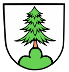
| Blazon : "A natural fir tree in silver on a green three-mountain." | |
| Justification of the coat of arms: The coat of arms indicates the location of the community "in the woods", the wooded area. The coat of arms appeared in the then mayor seal of Adelmannsfelden before the First World War. |
The municipal flag awarded by the District Office on July 2, 1980 is green and white.
Partnerships
Since 2007, Adelmannsfelden has had an official partnership with the Italian municipality of Bagnara di Romagna , Emilia-Romagna region , Ravenna province .
Economy and Infrastructure
traffic
Bundesstraße 19 runs seven kilometers south of Adelmannsfelden ; the next motorway junction, Ellwangen on federal motorway 7 , is 17 kilometers to the east. Both roads run from Würzburg to Ulm . The federal motorway 6 Nuremberg - Heilbronn runs about 20 km north of Adelmannsfelden .
The nearest train station is eleven kilometers east of Adelmannsfelden, Ellwangen on the Upper Jagstbahn , which is a station on the Karlsruhe - Nuremberg intercity connection . Bus route 7869 goes there on weekdays, and bus route 7698 goes to the district town of Aalen.
Educational institutions
Adelmannsfelden has its own primary school . There is also a Protestant kindergarten .
Sons and daughters of the church
- Franziska von Hohenheim (1748–1811), second wife of Duke Carl Eugen von Württemberg
- Rudolf Stadelmann (1902–1949), historian, professor of modern history
literature
Web links
Individual evidence
- ↑ State Statistical Office Baden-Württemberg - Population by nationality and gender on December 31, 2018 (CSV file) ( help on this ).
- ↑ Natural areas of Baden-Württemberg . State Institute for the Environment, Measurements and Nature Conservation Baden-Württemberg, Stuttgart 2009
- ^ The state of Baden-Württemberg. Official description by district and municipality. Volume IV: Administrative region of Stuttgart, regional associations of Franconia and East Württemberg. Kohlhammer, Stuttgart 1980, ISBN 3-17-005708-1 , pp. 706-708.
- ↑ State Statistical Office, area since 1988 according to actual use for Adelmannsfelden.
- ↑ Adelmannsfelden, in: Description of the Oberamt Aalen, Section B 3, pp. 206-218.
- ^ Members of the municipal council on the website of the municipality of Adelmannsfelden
- ↑ 2014 election results at the State Statistical Office of Baden-Württemberg (enter community name)
- ↑ http://www.schwaebische.de/region_artikel,-Wahlsieg-Edwin-Hahn- geht-in-die-dritte-Runde-_arid, 5108928.html
- ↑ Heinz Bardua: The communal coat of arms of the Ostalb district . Ostalb-Einhorn 10 (1983), pp. 75-88.
- ↑ Heinz Bardua: District and community arms in Baden-Württemberg. Volume 1: The district and community coats of arms in the Stuttgart administrative region . Landesarchivdirektion Baden-Württemberg (ed.), Konrad Theiss Verlag, Stuttgart 1987, ISBN 3-8062-0801-8 (158 pages).


