
Chiba prefecture
|
Chiba-ken 千葉 県 |
|
|---|---|
  |
|
| Basic data | |
| Administrative headquarters : | Chiba |
| Region : | Kanto |
| Main island : | Honshu |
| Area : | 5,157.6 km² |
| Water content: | 0.8 % |
| Residents : | 6,279,026 (October 1, 2019) |
| Population density : | 1217 inhabitants per km² |
| Counties : | 7th |
| Municipalities : | 54 |
| ISO 3166-2 : | JP-12 |
| Governor : | Kensaku Morita |
| Website: | www.pref.chiba.lg.jp |
| Symbols | |
| Prefecture flag : |
 |
| Prefecture tree : | Large-leaved stone slice |
| Prefecture flower : | Rapeseed blossom |
| Vogel prefecture : | Meadow bunting |
| Fish prefecture : | Sea bream |
| Prefecture song : |
Chiba-kenminka ("Song of the Citizens of Chiba") |
| Citizens Day: | 15th of July |
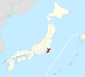
The Chiba Prefecture ( Jap. 千葉県 , Chiba-ken ) is a prefecture of Japan . It is located in the Kantō region on the southeast edge of the island of Honshū . The seat of the prefecture administration is the city of the same name, Chiba .
geography
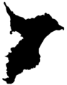
It borders on Ibaraki Prefecture to the north and Tokyo and Saitama Prefectures to the west . The prefecture extends largely over the Bōsō peninsula with the Bōsō hill country ( 房 総 丘陵 Bōsō-kyūryū ) whose highest point is the 402 m high Atago-yama. The northern part of the prefecture is largely formed by the Shimousa Plateau ( 下 総 台地 Shimousa-daichi ), while the fertile Kujūkuri Plain ( 九 十九 里 平野 Kujūkuri-heiya ) extends in the northeast of the prefecture .
The prefecture of Chiba is mainly known because the international airport of Tokyo is located here, near Narita , and also the Tokyo Disneyland in the area of Urayasu .
history
The prefecture of Chiba consists of the three former provinces of Awa , Kazusa and Shimousa and emerged, after several administrative reforms, on June 15, 1873 from the prefectures of Kisarazu and Imba, which had previously been formed .
The name Chiba means thousand leaves in German and was the name of a ruling family residing in this region between the 12th and 16th centuries.
Chiba is home to the Shinsho-ji Temple , a sprawling complex from the 10th century belonging to the Buddhist Shingon-shū , who are known for their strict asceticism.
Outline

Bōsō Peninsula
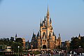
Tokyo Disneyland

Road signs in Chiba Prefecture


politics

Kensaku Morita has been governor of Chiba since 2009 , a former actor and member of the national parliament. He was re-elected for a third term in the March 2017 gubernatorial election. In the 94-member parliament which remained Liberal Democratic Party in the elections of April 2019 45 seats clearly the strongest party and holds non-party / acceding Group members its absolute majority.
In the national parliament Chiba is by 13 directly elected MPs in the lower house represented - in 2017 went twelve constituencies of Liberal Democrats, only in the constituency 4 remained without party nomination nominee Yoshihiko Noda of the Minshintō victorious - and the upper house , the prefecture elects three MPs per constituency and represented in the KDP parliamentary group by four Liberal Democrats and two MPs after the 2016 and 2019 elections and party reshuffles since then (as of August 2019) .
Partnerships
Chiba has partnerships with the state of Wisconsin in the US and the state of Pará in Brazil. Exchange relationships have also existed with the city of Düsseldorf in Germany since 2005 , which led to a partnership being concluded in 2019.
Administrative division
When today's community forms were introduced in 1889, Fukui was divided into 358 communities, 316 of which were villages. It was not until 1921 that Chiba was the first community to be elevated to the status of a city. The number of municipalities fell in almost 100 years from 349 (1920), over 310 (1950) and 111 (1955) to currently 54 (since 2005). The current breakdown shows 37 independent (-shi) and 16 district (-machi) cities as well as one remaining village (-mura). The number of counties ( - gun ) has fallen from 21 to six since 1889.
In the table below, the districts are shown in italics, below each (indented) the municipalities within them. The first two digits of the authority code are, as everywhere, the prefecture key of Chiba, the third digit indicates the type of authority as everywhere. The six districts have not had any significance as administrative units since the 1920s, but are still used for geographical division; they were therefore assigned round keys (divisible by 20); the 17 municipalities belonging to the district received consecutive keys; however, due to mergers / incorporations / upgrading to -shi, gaps have arisen in many places. The independent cities are at the beginning of the table. Among them, the capital Chiba, has been a “ major city by government ordinance” since 1992 . Funabashi has been a "core city" since 2003 , Kashiwas followed in 2008.
| code | Surname | Area (in km²) | population | Population density (inh / km²) 3 |
||
|---|---|---|---|---|---|---|
| Rōmaji | Kanji | October 1, 2018 1 | October 1, 2018 2 | October 1, 2015 3 | ||
| 12201 | Chiba- shi | 千葉 市 | 271.77 | 980.203 | 971.882 | 3576.1 |
| 12202 | Chōshi- shi | 銚 子 市 | 84.20 | 59,165 | 64,415 | 765.0 |
| 12203 | Ichikawa- shi | 市 川 市 | 57.45 | 495,592 | 481.732 | 8385.2 |
| 12204 | Funabashi- shi | 船 橋 市 | 85.62 | 639.107 | 622.890 | 7275.1 |
| 12205 | Tateyama- shi | 館 山 市 | 110.05 | 45,300 | 47,464 | 431.3 |
| 12206 | Kisarazu- shi | 木 更 津市 | 138.95 | 135,765 | 134.141 | 965.4 |
| 12207 | Matsudo- shi | 松 戸 市 | 61.38 | 492,671 | 483,480 | 7876.8 |
| 12208 | Noda- shi | 野 田 市 | 103.55 | 152,652 | 153,583 | 1483.2 |
| 12210 | Mobara -shi | 茂 原 市 | 99.92 | 87,450 | 89,688 | 897.6 |
| 12211 | Narita- shi | 成 田 市 | 213.84 | 132.293 | 131,190 | 613.5 |
| 12212 | Sakura- shi | 佐 倉 市 | 103.69 | 170.906 | 172,739 | 1665.9 |
| 12213 | Tōgane- shi | 東 金 市 | 89.12 | 58,686 | 60,652 | 680.6 |
| 12215 | Asahi- shi | 旭 市 | 130.45 | 64,302 | 66,586 | 510.4 |
| 12216 | Narashino- shi | 習 志 野 市 | 20.97 | 173.716 | 167.909 | 8007.1 |
| 12217 | Kashiwa- shi | 柏 市 | 114.74 | 429.070 | 413,954 | 3607.8 |
| 12218 | Katsuura- shi | 勝浦 市 | 93.96 | 17,324 | 19,248 | 204.9 |
| 12219 | Ichihara -shi | 市 原 市 | 368.17 | 270,478 | 274,656 | 746.0 |
| 12220 | Nagareyama- shi | 流 山 市 | 35.32 | 193.976 | 174,373 | 4937.0 |
| 12221 | Yachiyo- shi | 八千 代 市 | 51.39 | 197,792 | 193.152 | 3758.6 |
| 12222 | Abiko- shi | 我 孫子 市 | 43.15 | 131.026 | 131.606 | 3050.0 |
| 12223 | Kamogawa- shi | 鴨 川 市 | 191.14 | 32,196 | 33,932 | 177.5 |
| 12224 | Kamagaya- shi | 鎌 ケ 谷 市 | 21.08 | 109,525 | 108.917 | 5166.8 |
| 12225 | Kimitsu -shi | 君 津市 | 318.81 | 82,548 | 86.033 | 269.9 |
| 12226 | Futtsu- shi | 富 津市 | 205.53 | 43.213 | 45.601 | 221.9 |
| 12227 | Urayasu- shi | 浦 安 市 | 17.30 | 170.343 | 164.024 | 9481.2 |
| 12228 | Yotsukaidō- shi | 四 街道 市 | 34.52 | 92,668 | 89,245 | 2585.3 |
| 12229 | Sodegaura -shi | 袖 ケ 浦 市 | 94.93 | 63,135 | 60,952 | 642.1 |
| 12230 | Yachimata- shi | 八 街市 | 74.94 | 67,522 | 70,734 | 943.9 |
| 12231 | Inzai -shi | 印 西 市 | 123.79 | 100.907 | 92,670 | 748.6 |
| 12232 | Shiroi- shi | 白 井 市 | 35.48 | 61,931 | 61,674 | 1738.3 |
| 12233 | Tomisato -shi | 富 里 市 | 53.88 | 49,868 | 49,636 | 921.2 |
| 12234 | Minamibōsō- shi | 南 房 総 市 | 230.12 | 36,412 | 39,033 | 169.6 |
| 12235 | Sosa shi | 匝 瑳 市 | 101.52 | 35,186 | 37,261 | 367.0 |
| 12236 | Katori- shi | 香 取 市 | 262.35 | 73.110 | 77,499 | 295.4 |
| 12237 | Sammu shi | 山 武 市 | 146.77 | 49,300 | 52,222 | 355.8 |
| 12238 | Isumi- shi | い す み 市 | 157.50 | 36,264 | 38,594 | 245.0 |
| 12239 | Ōamishirasato -shi | 大 網 白 里 市 | 58.08 | 47,990 | 49.184 | 846.8 |
| 12320 | Inba-gun | 印 旛 郡 | 51.52 | 42,183 | 818.8 | |
| 12322 | Shisui-machi | 酒 々 井 町 | 19.01 | 20,470 | 20,955 | 1102.3 |
| 12329 | Sakae-machi | 栄 町 | 32.51 | 20,217 | 21,228 | 653.0 |
| 12340 | Katori gun | 香 取 郡 | 138.95 | 35.009 | 252.0 | |
| 12342 | Kozaki-machi | 神 崎 町 | 19.90 | 5827 | 6133 | 308.2 |
| 12347 | Tako-machi | 多 古 町 | 72.80 | 14,021 | 14,724 | 202.3 |
| 12349 | Tōnoshō- machi | 東庄 町 | 46.25 | 13,346 | 14,152 | 306.0 |
| 12400 | Sanbu-gun | 山 武 郡 | 134.71 | 47,703 | 354.1 | |
| 12403 | Kujūkuri-machi | 九 十九 里 町 | 24.46 | 15,075 | 16,510 | 675.0 |
| 12409 | Shibayama-machi | 芝山 町 | 43.24 | 7082 | 7431 | 171.9 |
| 12410 | Yokoshibahikari-machi | 横 芝 光 町 | 67.01 | 22,585 | 23,762 | 354.6 |
| 12420 | Chōsei-gun | 長生 郡 | 226.97 | 60,040 | 264.5 | |
| 12421 | Ichinomiya-machi | 一 宮 町 | 22.97 | 11,780 | 11,767 | 512.3 |
| 12422 | Mutsuzawa-machi | 睦 沢 町 | 35.59 | 6839 | 7222 | 202.9 |
| 12423 | Chōsei-mura | 長生 村 | 28.29 | 13,859 | 14,359 | 507.6 |
| 12424 | Shirako-machi | 白子 町 | 27.50 | 10,489 | 11,149 | 405.4 |
| 12426 | Nagara-machi | 長柄 町 | 47.11 | 6886 | 7337 | 155.7 |
| 12427 | Chonan-machi | 長 南 町 | 65.51 | 7563 | 8206 | 125.3 |
| 12440 | Isumi-gun | 夷 隅 郡 | 154.72 | 17,158 | 110.9 | |
| 12441 | Ōtaki-machi | 大多 喜 町 | 129.87 | 9049 | 9843 | 75.8 |
| 12443 | Onjuku-machi | 御 宿 町 | 24.85 | 6970 | 7315 | 294.4 |
| 12460 | Awa-gun | 安 房 郡 | 45.19 | 8022 | 177.5 | |
| 12463 | Kyonan-machi | 鋸 南 町 | 45.19 | 7377 | 8022 | 177.5 |
| Shi-bu ( All Shi , proportion of urban districts) | 市 部 | 4405.54 | 6,066,053 | 6,012,551 | 1364.8 | |
| Gun-bu ( All Gun , percentage of counties) | 郡 部 | 752.07 | 202,532 | 210.115 | 279.4 | |
| 12000 | Chiba-Ken (Chiba Prefecture) | 千葉 県 | 5157.61 | 6,268,585 | 6,222,666 | 1206.5 |
Sources
1 Area data from 2018
2 Estimated population 2018
3 Results of the 2015 census
Biggest places
| VZ year | Residents | |||
|---|---|---|---|---|
| 2015 | 2010 | 2005 | 2000 | |
| Chiba | 971.882 | 961.749 | 924,319 | 887.164 |
| Funabashi | 622.890 | 609.040 | 569,835 | 550.074 |
| Matsudo | 483,480 | 484.457 | 472,579 | 464.841 |
| Ichikawa | 481.732 | 473.919 | 466,608 | 448,642 |
| Kashiwa | 413,954 | 404.012 | 380,963 | 327.851 |
| Ichihara | 274,656 | 280.416 | 280.255 | 278.218 |
| Yachiyo | 193.152 | 189,781 | 180.729 | 168,848 |
| Nagareyama | 174,373 | 163.984 | 152.641 | 150,527 |
| Sakura | 172,739 | 172.183 | 171,246 | 170.934 |
| Narashino | 167.909 | 164,530 | 158,785 | 154.036 |
| Urayasu | 164.024 | 164,877 | 155.290 | 132,984 |
| Noda | 153,583 | 155.491 | 151.240 | 119.922 |
| Kisarazu | 134.141 | 129,312 | 122.234 | 122,768 |
| Abiko | 131.606 | 134.017 | 131.205 | 127,733 |
| Narita | 131,190 | 128,933 | 100,717 | 95,704 |
| Kamagaya | 108.917 | 107,853 | 102,812 | 102,573 |
| Inzai | 92,670 | 88.176 | 60,060 | 60,468 |
| Mobara | 89,688 | 93.015 | 93,260 | 93,779 |
| Yotsukaidō | 89,245 | 86,726 | 84,770 | 82,552 |
| Kimitsu | 86.033 | 89,168 | 90,977 | 92,076 |
| Katori | 77,499 | 82,866 | —— | —— |
| Yachimata | 70,734 | 73.212 | 75,735 | 72,595 |
| Asahi | 66,586 | 69,058 | 70,643 | 40,963 |
| Chōshi | 64,415 | 70.210 | 75.020 | 78,697 |
| Shiroi | 61,674 | 60,345 | 53.005 | —— |
| Sodegaura | 60,952 | 60,355 | 59,108 | 58,593 |
| Togane | 60,652 | 61,751 | 61,701 | 59,605 |
| Sanmu | 52,222 | 56,089 | —— | —— |
| Tomisato | 49,636 | 51,087 | 51,370 | —— |
| Ōamishirasato | 49.184 | —— | —— | —— |
| Tateyama | 47,464 | 49,290 | 50,527 | 51,412 |
| Futtsu | 45.601 | 48,073 | 50.162 | 52,839 |
| Minamibōsō | 39,033 | 42,104 | —— | —— |
| Isumi | 38,594 | 40,962 | —— | —— |
| Sosa | 37,261 | 39,814 | —— | —— |
| Kamogawa | 33,932 | 35,766 | 36,475 | 29,981 |
| Katsuura | 19,248 | 20,788 | 22,198 | 23,235 |
| Sawara | —— | —— | 45,965 | 48,328 |
| Yokaichiba | —— | —— | 32,067 | 32,807 |
- April 1, 2001 - The small town of Shiroi is elevated to an independent city .
- April 1, 2002 - The small town of Tomisato is raised to the status of an independent city .
- December 5, 2005 - The small town of Isumi integrates two communities and becomes a district-free city .
- January 23, 2006 - The city of Yōkaichiba integrates a municipality and becomes the independent city of Sōsa .
- March 20, 2006 - Seven municipalities merge to form the independent city of Minamibōsō .
- March 27, 2006 - The independent city of Sawara and three municipalities form the new (independent) city of Katori .
- March 27, 2006 - Four municipalities merge to form the new city of Sanmu .
- March 27, 2006 - Two parishes merge to form the new city of Yokoshibahikari .
- January 1, 2013 - The small town of Ōamishirasato receives the status of an independent city .
Population development in the prefecture
| Census year |
Total population |
male population |
female population |
Gender ratio men to 1000 women |
Area in km² |
Population density per km 2 |
|---|---|---|---|---|---|---|
| 1920 | 1,336,155 | 656.968 | 679.187 | 967 | 5078.81 | 263.1 |
| 1925 | 1,399,257 | 691.242 | 708.015 | 976 | 5078.81 | 275.5 |
| 1930 | 1,470,121 | 729.439 | 740.682 | 985 | 5078.81 | 289.5 |
| 1935 | 1,546,394 | 764.751 | 781.643 | 978 | 5062.09 | 305.5 |
| 1940 | 1,588,425 | 776,541 | 811.884 | 957 | 5062.09 | 313.8 |
| 1945 | 1,966,862 | 908.228 | 1,058,634 | 858 | 5062.09 | 388.6 |
| 1950 | 2,139,037 | 1,036,932 | 1,102,105 | 941 | 5032.16 | 425.1 |
| 1955 | 2,205,060 | 1,074,181 | 1,130,879 | 950 | 5033.92 | 438.0 |
| 1960 | 2.306.010 | 1,128,734 | 1,177,276 | 959 | 5034.43 | 458.1 |
| 1965 | 2,701,770 | 1,343,167 | 1,358,603 | 989 | 5050.46 | 535.0 |
| 1970 | 3,366,624 | 1,694,854 | 1,671,770 | 1014 | 5078.86 | 662.9 |
| 1975 | 4,149,147 | 2,095,295 | 2,053,852 | 1020 | 5114.82 | 811.2 |
| 1980 | 4,735,424 | 2,383,157 | 2,352,267 | 1013 | 5142.60 | 920.8 |
| 1985 | 5,148,163 | 2,588,365 | 2,559,798 | 1011 | 5150.14 | 999.6 |
| 1990 | 5,555,429 | 2,802,774 | 2,752,655 | 1018 | 5155.75 | 1077.5 |
| 1995 | 5,797,782 | 2,923,839 | 2,873,943 | 1017 | 5155.98 | 1124.5 |
| 2000 | 5,926,285 | 2,976,984 | 2,949,301 | 1009 | 5156.19 | 1149.4 |
| 2005 | 6,056,462 | 3,029,486 | 3,026,976 | 1001 | 5156.68 | 1174.5 |
| 2010 | 6.216.289 | 3,098,139 | 3,118,150 | 994 | 5156.70 | 1205.5 |
| 2015 | 6,222,666 | 3,095,860 | 3,126,806 | 990 | 5157.65 | 1206.5 |
Culture
Traditionally, the prefecture of Chiba is the partner region of the Japan Day in Düsseldorf , which takes place once a year in early summer - a German-Japanese festival with over a million visitors.
Symbols
Chiba meibutsu ( "known thing") are peanuts. Most of Japan's peanuts are harvested here and also processed into peanut oil.
See also
Web links
Individual evidence
- ↑ Chiba Prefectural Parliament : Members by parliamentary group , accessed August 6, 2019
- ↑ 統一 地方 選 2019 千葉 県 議 選 各 党 議席 . In: NHK Senkyo Web. April 8, 2019. Retrieved May 23, 2019 (Japanese).
- ↑ Chiba Prefecture Administration : International Partnerships of the Chiba Prefecture and the Municipalities in Chiba (Japanese)
- ↑ Chiba Prefecture Administration : デ ュ ッ セ ル ド ル フ 市 と の 交流
- ↑ Chiba Prefecture Administration, January 31, 2019: ド イ ツ ・ デ ュ ッ セ ル ド ル フ 市 と の 姉妹 提携 に つ い て , accessed March 25, 2019.
- ↑ State capital Düsseldorf: City council decides city partnership with Chiba. Retrieved March 8, 2019 .
- ↑ Kokudo Chiriin (GSI - Geospatial Information Authority of Japan), 平 成 30 年 全国 都 道 府 県 市区 町 村 別 面積 調 (Nationwide survey of all prefectures and municipalities 2018) , p. 37: 12 Chiba-ken (Japanese), accessed on 1 April 2019
- ↑ [1] (Japanese) Retrieved April 1, 2019
- ↑ e-stat (English), accessed on April 1, 2019
- ↑ e-Stat database , accessed on April 1, 2019 (English)
- ↑ e-Stat database , accessed on April 1, 2019 (English)
Aichi | Akita | Aomori | Chiba | Ehime | Fukui | Fukuoka | Fukushima | Gifu | Gunma | Hiroshima | Hokkaidō | Hyōgo | Ibaraki | Ishikawa | Iwate | Kagawa | Kagoshima | Kanagawa | Kochi | Kumamoto | Kyoto | Mie | Miyagi | Miyazaki | Nagano | Nagasaki | Nara | Niigata | Ōita | Okayama | Okinawa | Osaka | Saga | Saitama | Shiga | Shimane | Shizuoka | Tochigi | Tokyo | Tokushima | Tottori | Toyama | Wakayama | Yamagata | Yamaguchi | Yamanashi
Coordinates: 35 ° 39 ' N , 140 ° 6' E