
Congy
| Congy | ||
|---|---|---|

|
|
|
| region | Grand Est | |
| Department | Marne | |
| Arrondissement | Epernay | |
| Canton | Dormans-Paysages de Champagne | |
| Community association | Paysages de la Champagne | |
| Coordinates | 48 ° 52 ′ N , 3 ° 50 ′ E | |
| height | 142-237 m | |
| surface | 17.47 km 2 | |
| Residents | 262 (January 1, 2017) | |
| Population density | 15 inhabitants / km 2 | |
| Post Code | 51270 | |
| INSEE code | 51163 | |
 City Hall (Mairie) of Congy |
||

Congy is a French commune with 262 inhabitants (as of January 1, 2017) in the Marne department in the Grand Est region (before 2016 Champagne-Ardenne ). It belongs to the Arrondissement Épernay and the canton Dormans-Paysages de Champagne (until 2015 Montmort-Lucy ). The inhabitants are called Bayens .
geography
Congy is located about 39 kilometers south-southwest of Reims . Congy is surrounded by the neighboring communities of Montmort-Lucy in the north, Étoges in the east and northeast, Fèrebrianges in the east, Vert-Toulon in the east and southeast, Coizard-Joches in the south and southeast, Villevenard in the south and southwest, Baye in the west, Champaubert in the West and northwest and La Caure to the northwest.
Population development
| year | 1962 | 1968 | 1975 | 1982 | 1990 | 1999 | 2006 | 2011 | 2017 |
| Residents | 395 | 379 | 334 | 302 | 315 | 288 | 273 | 253 | 262 |
| Sources: Cassini and INSEE | |||||||||
Attractions
- Menhir (called Pierre-Fitte), Monument historique since 1889
- Saint-Rémy church from the 12th / 13th centuries Century, since 1986 Monument historique
- Congy Castle from 1825
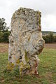
Menhir Pierre-Fitte

Saint-Rémy church

Baye Castle


