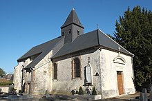
Val-des-Marais
| Val-des-Marais | ||
|---|---|---|
|
|
||
| region | Grand Est | |
| Department | Marne | |
| Arrondissement | Epernay | |
| Canton | Canton of Vertus-Plaine Champenoise | |
| Community association | Communauté d'agglomération Épernay, Coteaux et Plaine de Champagne | |
| Coordinates | 48 ° 51 ′ N , 3 ° 58 ′ E | |
| height | 129-237 m | |
| surface | 39.85 km 2 | |
| Residents | 567 (January 1, 2017) | |
| Population density | 14 inhabitants / km 2 | |
| Post Code | 51130 | |
| INSEE code | 51158 | |
Val-des-Marais is a French commune with 567 inhabitants (as of January 1, 2017) in the Marne department in the Grand Est region (before 2016 Champagne-Ardenne ). It belongs to the Arrondissement Épernay (until 2017 Châlons-en-Champagne ) and the canton Vertus-Plaine Champenoise (until 2015 Vertus ).
location
Val-des-Marais is about 22 kilometers south of Épernay . Val-des-Marais is surrounded by the neighboring communities Vert-Toulon in the north and west, Étréchy in the north, Bergères-lès-Vertus in the north and northeast, Pierre-Morains in the east, Écury-le-Repos in the southeast, Fère-Champenoise in the South as well as Bannes in the southwest.
history
In 1977 the municipality was formed from the previously independent municipalities Aulnay-aux-Planches , Aulnizeux , Coligny and Morains .
Population development
| year | 1962 | 1968 | 1975 | 1982 | 1990 | 1999 | 2006 | 2011 | 2017 |
|---|---|---|---|---|---|---|---|---|---|
| Residents | 282 | 310 | 288 | 525 | 532 | 490 | 544 | 572 | 567 |
| Sources: Cassini and INSEE | |||||||||
Attractions
- Dolmen of La Plaque, Monument historique since 1937
- Coligny church from the 16th century
- Saint-Fal church in Aulnay-aux-Planches
- Aulnay-aux-Planches Castle
- Mont Aimé castle ruins in Coligny

