
Pierry
| Pierry | ||
|---|---|---|

|
|
|
| region | Grand Est | |
| Department | Marne | |
| Arrondissement | Epernay | |
| Canton | Épernay-2 | |
| Community association | Epernay, Coteaux et Plaine de Champagne | |
| Coordinates | 49 ° 1 ′ N , 3 ° 56 ′ E | |
| height | 67-262 m | |
| surface | 5.16 km 2 | |
| Residents | 1,181 (January 1, 2017) | |
| Population density | 229 inhabitants / km 2 | |
| Post Code | 51530 | |
| INSEE code | 51431 | |
| Website | http://balade-pierry.fr/ | |
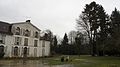
 Town Hall (Mairie) by Pierry |
||

Pierry is a French commune with 1,181 inhabitants (as of January 1, 2017) in the Marne department in the Grand Est region . It belongs to the Arrondissement of Épernay and the Canton of Épernay-2 . The inhabitants are called Pierrytièrs .
geography
Pierry is located about 27 kilometers south-southwest of Reims . Pierry is surrounded by the neighboring communities of Épernay in the north, Chouilly in the east, Cuis in the south and southeast, Monthelon in the south and Moussy in the west.
Population development
| year | 1962 | 1968 | 1975 | 1982 | 1990 | 1999 | 2006 | 2017 |
| Residents | 1382 | 1269 | 1157 | 1139 | 1500 | 1395 | 1236 | 1181 |
| Sources: Cassini and INSEE | ||||||||
Attractions
- Saint-Julien church
- priory
- Pierry Castle, built in 1750
- Les Aulnois Castle, built in 1780
- La Marquetterie Castle, largely built in 1734
- park

Saint-Julien church
priory

La Marquetterie Castle

Les Aulnois Castle


Personalities
- Xavier Aubryet (1827–1880), journalist and writer
- Jacques Cazotte (1719–1792), writer
- Jean Oudart (1654–1742), Benedictine monk, winery administrator (Dom Pérignon)
Web links
Commons : Pierry - collection of images, videos and audio files