
Mömlingen
| coat of arms | Germany map | |
|---|---|---|

|
Coordinates: 49 ° 52 ' N , 9 ° 5' E |
|
| Basic data | ||
| State : | Bavaria | |
| Administrative region : | Lower Franconia | |
| County : | Miltenberg | |
| Height : | 148 m above sea level NHN | |
| Area : | 18.46 km 2 | |
| Residents: | 4889 (Dec. 31, 2019) | |
| Population density : | 265 inhabitants per km 2 | |
| Postal code : | 63853 | |
| Area code : | 06022 | |
| License plate : | MIL, OBB | |
| Community key : | 09 6 76 140 | |
| LOCODE : | DE MMG | |
| Community structure: | 1 district | |
| Address of the municipal administration: |
Hauptstrasse 70 63853 Mömlingen |
|
| Website : | ||
| Mayor : | Siegfried Scholtka ( CSU ) | |
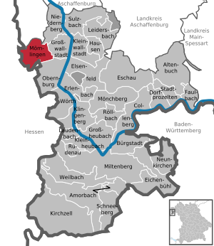
| Location of the community Mömlingen in the district of Miltenberg | ||
  |
||

Mömlingen is a municipality in the Miltenberg district in Lower Franconia .
geography
Geographical location
Mömlingen, with its own name "Tor zum Odenwald", is framed by the wooded heights of the northern Odenwald on the Bavarian-Hessian border in the charming Mümlingtal . It has no other officially named districts. Mömlingen is bordered by the Bavarian district of Aschaffenburg in the north and the two districts of Hesse, Darmstadt-Dieburg and Odenwaldkreis, in the west . The topographically highest point of the municipality district is located at 306 m above sea level. NN at the summit of the Buchberg, the lowest is on the Mömling, south of the village, at 129 m above sea level. NN .
Neighboring communities
| Community Schaafheim |
Großostheim market |
Community Niedernberg |
| City of Groß-Umstadt |
.svg)
|
Community Großwallstadt |
| City of Breuberg |
City of Obernburg am Main |
Surname
etymology
It is not known exactly from which the name Mömlingen is actually derived. There are three possible theories:
- The place name is derived from the Mümling river , on which the village is located. The name Mümling belongs to the "old European hydronymy ", which historically extends beyond the boundaries of the individual Indo-European language families; it is probably to be seen as a parallel to the river name Memel .
- The name of the settlement is based on the old personal name Mimino , which was derived from an affiliation suffix ing . The river name is derived from the place name and was derived from the Old High German word aha , for water.
- The place and river names were initially created in parallel and independently of each other. Later parts of the name of each were adapted.
Earlier spellings
Earlier spellings of the place from various historical maps and documents:
|
|
|
history

Celts and Romans
Numerous barrows and individual finds, several of which date back to the Stone Age, testify to settlement in prehistoric epochs . Parts of the so-called Jupiter giant columns and other god stones date from the Roman era . Together with numerous traces of Roman country houses ( villae rusticae ) on the heights around Mömlingen, they point to the extent of the former Roman Empire, which was limited a few kilometers further east by the Nassen Limes , the Main .
Franconian settlement
An early Franconian settlement of today's town center from the 6th century onwards is proven by an extensive row of graves that was uncovered by archaeologists west of the village. In addition to numerous graves with missing or scanty additions, tombs with exceptionally rich furnishings (including a Mainz gold coin and remains of silk ) were discovered, which suggests a "noble" upper class among the villagers. This probably steered the Frankish conquest in this area on royal order.
First documentary mention
The settlement itself is first encountered as Miminingen in a document from the imperial monastery of Fulda , which was made out between 802 and 817 (term of office of Abbot Ratgar). Compared to many neighboring communities, this is a very early first mention. The construction of the first church in Mömlingen can also be dated to the early Franconian period. This is supported by the Martin patronage of the old parish church , which is considered typically Franconian .
Church and nobility - Mainz and Breuberg
From the time of the Middle Ages we know of numerous ecclesiastical institutions and members of the higher and lower nobility who owned land in the area, received taxes and had other rights. In 1024, Emperor Heinrich II gave the County of Stockstadt, to which Mömlingen belonged, to the imperial abbey of Fulda. In 1278 the place came with the county of Bachgau to the ore monastery Mainz . The fact that Mömlingen belonged politically (until 1803) to the Electoral Mainz district of Bachgau , while the village jurisdiction, extensive land ownership and other traditional claims belonged to the lords of the nearby Breuberg Castle with the Breuberg rule , led to constant disputes between the territorial powers Mainz and Breuberg.
Lords of Mimling - Hans Memling
In the later Middle Ages, members of a probably low-aristocratic family "von Mimling" (and similarly written) appear in the documents, mostly as clergymen and centgraves . On the part of historical research there is no doubt that the ancestors of the famous painter Hans Memling, who was born in Seligenstadt around 1435, also come from Mömlingen. Today his works can be found in the most famous picture galleries in the world.
House behind the sun
(Location: 49 ° 50 ′ 32 ″ N, 9 ° 3 ′ 54 ″ E )
In the south of Mömlingen, on the northern slope of the “Buchberg”, the village of “Hausen Behind the Sun” , which belonged to the Bamberg cathedral monastery , once stood . The huge nationwide plague wave of 1348 is likely to have decimated the town's population for a long time. Probably due to the effects of the war, the last residents of the small neighboring town moved to Mömlingen in the early 16th century. The Mömlinger district thus experienced a significant increase. The neighboring Hainstadt also benefited regionally from the desolation of the village. The village should not be confused with Hausen near Obertshausen, which was also called Hausen Behind the Sun to distinguish it from the hamlet of Hausen vor der Sonne to the west of Hofheim am Taunus .
Consequences of the Thirty Years War

Details about the size of Mömlingen at the end of the Middle Ages can be found in an interest register from 1426. At this time, the Counts of Wertheim, as owners of the Breuberg estate, received royalties from 62 farms; Mömlingen was therefore a very impressive settlement. The Thirty Years War (1618–1648) had a serious impact on Mömlingen's development . Pest , looting and arson continued population too hard, so that in 1650 only are still listed a few survivors. This terrible war wiped out many long-established families. Soon after the end of the war, we encounter a multitude of new names in the archives. Immigrants came mainly from South Tyrol, France and the Netherlands. The Thirty Years War also prevented the establishment of a new local church; only a bell tower was built. It was not until 1774/1777 that the Mömlingers were able to realize their plan. The old parish church, built in baroque style , is today the symbol of the community.
Mömlingen comes to Bavaria
At the beginning of the 19th century, an epoch lasting over 600 years came to an end when Mömlingen was politically part of the Electorate of Mainz . In 1803 it came to the newly established Principality of Aschaffenburg , with this in 1810 to the short-lived Grand Duchy of Frankfurt and finally to Bavaria on June 26, 1814 , where it was on the administrative territory of the Obernburg Regional Court.
In 1862 the Obernburg District Office was formed from the Obernburg Regional Court . As everywhere in the German Reich , the term district was introduced in 1939. Mömlingen was now one of the 35 communities in the district of Obernburg am Main . With the dissolution of the district of Obernburg, Mömlingen came into the newly formed district of Miltenberg in 1972 .
Today, the municipality of Mömlingen , which was structurally greatly enlarged in the post-war period, presents itself as a small center that has a colorful range of non-profit institutions and whose scenic location is appreciated by many visitors.
politics

Municipal council
The municipal council has 16 members.
(Status: local election on March 15, 2020)
mayor
Siegfried Scholtka (CSU) has been mayor since May 1, 2008; he was last elected on March 15, 2020 with 92.8 percent of the vote for a further six years.
coat of arms
The description of the coat of arms introduced in 1955 reads: "In red a six-spoke silver wheel, accompanied at the top by three semicircular arranged silver heraldic roses with golden lugs, at the bottom by two six-pointed silver stars."
Town twinning

![]() A partnership has existed with the municipality of La Rochette in France since 1992 .
A partnership has existed with the municipality of La Rochette in France since 1992 .
Architectural monuments

- Parish Church of St. Martin, a baroque church, built between 1774 and 1777
Regular events
- April: spring market
traffic
Mömlingen was connected to the SPNV by the Aschaffenburg – Höchst (Odenwald) railway with the Mömlingen Ort stop and Mömlingen train station .
Since closure of the route to the nearest are stations maximum (Odenw) at the Odenwaldbahn and Aschaffenburg South on the railway line Aschaffenburg-Miltenberg .
Oddities
The Mömlingers made the mashed potato a delicacy . Not only as a side dish to sauerkraut , but also fried in oil with a crispy crust. Elsewhere they were also called “Gänssteppel” because they had the shape of the stuffed sausages in goose fattening, which is now forbidden. The residents raved about their "Stampes" so much that they stayed as a local name .
Personalities
- Hans Memling (1433 / 1440–1494), painter
- Drafi Deutscher (1946–2006), singer, lived in Mömlingen for the last years of his life
- Hans Dieter Klein (* 1951), photographer and science fiction author, grew up in Mömlingen
literature
- Adam Otto Vogel: Home and local history Mömlingen . Self-published, 1930.
- Wolfgang Hartmann (Ed.): Mömlingen - as it used to be . An illustrated book with historical photographs and stories of Mömlingen from the period 1871 - 1951.
- Wolfgang Hartmann (Ed.): Mömlingen - through the ages . An illustrated book with historical photographs and stories from Mömlingen from 1952 to 1977.
- Karl Bolz: Mömlingen in the 20th century . Ed .: Wolfgang Hartmann.
- Wolfgang Hartmann (Ed.): 1200 years of Mömlingen . Contributions to history. Mömlingen 2017.
Web links
- History portal Mömlingen
- Entry on the Mömlingen coat of arms in the database of the House of Bavarian History
- Mömlingen: Official statistics of the LfStat
- Mömlingen in the location database of the Bayerische Landesbibliothek Online . Bavarian State Library
Individual evidence
- ↑ "Data 2" sheet, Statistical Report A1200C 202041 Population of the municipalities, districts and administrative districts 1st quarter 2020 (population based on the 2011 census) ( help ).
- ↑ a b c Wolf-Armin von Reitzenstein : Lexicon of Franconian place names. Origin and meaning . Upper Franconia, Middle Franconia, Lower Franconia. CH Beck, Munich 2009, ISBN 978-3-406-59131-0 , p. 150 ( limited preview in Google Book search).
- ^ Certificate of Heinrich V (Latin) on page 509 in Complete Hoch-Gräflich-Erbachische Historie. by Daniel Schneider, 1736 in the Google book search
- ^ German reproduction of Heinrich V's document (Latin) on page 261 in Complete Hoch-Gräflich-Erbachische Historie. by Daniel Schneider, 1736 in the Google book search
- ↑ http://www.wahlen.bayern.de/kommunalwahlen/
- ↑ Werner Trost Stampes, Worzelköpp and Staffelbrunzer Lkr.Miltenberg 2003

Altenbuch | Amorbach | Bürgstadt | Collenberg | Dorfprozelten | Eichenbühl | Elsenfeld | Erlenbach am Main | Eschau | Faulbach | Großheubach | Großwallstadt | Hausen | Kirchzell | Kleinheubach | Kleinwallstadt | Klingenberg am Main | Laudenbach | Leidersbach | Miltenberg | Mömlingen | Mönchberg | Neunkirchen | Niedernberg | Obernburg am Main | Röllbach | Rüdenau | Schneeberg | Stadtprozelten | Sulzbach am Main | Weilbach | Wörth a.Main
Unregulated areas: forest forest | High maintenance