
Isili
| Isili | ||
|---|---|---|

|
|
|
| Country | Italy | |
| region | Sardinia | |
| province | South Sardegna (SU) | |
| Local name | Ìsiri | |
| Coordinates | 39 ° 45 ' N , 9 ° 7' E | |
| height | 523 m slm | |
| surface | 67.93 km² | |
| Residents | 2,579 (Dec. 31, 2019) | |
| Population density | 38 inhabitants / km² | |
| Post Code | 08033 | |
| prefix | 0782 | |
| ISTAT number | 111036 | |
| Patron saint | San Saturno | |
| Website | Isili | |

Isili is an Italian municipality in the province of Sud Sardegna and the economic center of central Sardinia with 2579 inhabitants (as of December 31, 2019).
The municipality is located about 70 km north of Cagliari and covers an area of 67.9 km². Neighboring communities are Gergei , Gesturi , Laconi , Nuragus , Nurallao , Nurri , Serri and Villanova Tulo .
The parish church of San Giuseppe Calasanzio with its gleaming white facade and the Is Paras nuraghe made of white limestone are well worth seeing . The giant grave of Murisiddi is located on the northwest bank of the Is Barrocus reservoir . Climbers and mountaineers mostly visit the rocks of the Riu Sarcidano gorge .
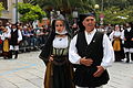
Traditional costume

Look at Isili

Isili station

Nuraghe Is Paras

Is Barrocus reservoir
.JPG)


Web links
- Comune site of Isili (Italian)
Individual evidence
- ↑ Statistiche demografiche ISTAT. Monthly population statistics of the Istituto Nazionale di Statistica , as of December 31 of 2019.