
Barumini
| Barumini | ||
|---|---|---|

|
|
|
| Country | Italy | |
| region | Sardinia | |
| province | South Sardegna (SU) | |
| Local name | Barùmini | |
| Coordinates | 39 ° 42 ′ N , 9 ° 0 ′ E | |
| height | 202 m slm | |
| surface | 26.57 km² | |
| Residents | 1,225 (Dec. 31, 2019) | |
| Population density | 46 inhabitants / km² | |
| Post Code | 09021 | |
| prefix | 070 | |
| ISTAT number | 111005 | |
| Popular name | baruminesi | |
| Patron saint | San Sebastiano | |
| Website | http://www.comunebarumini.it/ | |

Barumini is a municipality in the Marmilla , the center of Sardinia , in the province of Sud Sardegna with 1225 inhabitants (as of December 31, 2019). The place lies south of the plateau called Giara di Gesturi .
Neighboring communities
Barumini's neighboring communities are, in alphabetical order, Gergei , Gesturi , Las Plassas , Tuili and Villanovafranca . They are all in the province of Sud Sardegna.
Attractions
The Palazzo Zapata, which was built by the Aragonese Zapata family at the end of the 16th and beginning of the 17th century, is important. During restoration work in the 1990s, it was discovered that the palace had been built on the ruins of a nuragic complex ( Nuraxi 'e Cresia ). Today there is a museum in the palazzo; The remains of the nuraghi are visible above glass floors and bridges. Also worth seeing are the reredos by an unknown master who probably came from the Stampace school , the polychrome predella in the sacristy of the parish church "Vergine Immacolata" and the church of San Giovanni Batista from the 13th century.
To the west of the village on a hill on the road to Tuili is the well-preserved five-phase built and converted large nuraghe Su Nuraxi , which is a UNESCO World Heritage Site .

Parish Church "Vergine Immacolata"
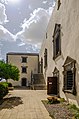
Palazzo Zapata

Palazzo Zapata

San Giovanni Batista

Nuraghe


Web links
Individual evidence
- ↑ Statistiche demografiche ISTAT. Monthly population statistics of the Istituto Nazionale di Statistica , as of December 31 of 2019.
- ↑ http://barumini.altervista.org/palazzo%20zapata.htm , accessed on October 14, 2016 (it.)