
Küsnachter Dorfbach
| Küsnachter Dorfbach | ||
 The village stream in its lower part |
||
| Data | ||
| Water code | CH : 688 | |
| location | Canton of Zurich ; Switzerland | |
| River system | Rhine | |
| Drain over | Lake Zurich → Limmat → Rhine | |
| source | Rear guilder 47 ° 18 ′ 35 ″ N , 8 ° 39 ′ 7 ″ E |
|
| Source height | approx. 736 m above sea level M. | |
| muzzle | in Lake Zurich coordinates: 47 ° 19 ′ 3 ″ N , 8 ° 34 ′ 37 ″ E ; CH1903: 686 055 / 241360 47 ° 19 '3 " N , 8 ° 34' 37" O |
|
| Mouth height | 406 m above sea level M. | |
| Height difference | approx. 330 m | |
| Bottom slope | approx. 41 ‰ | |
| length | 8 kilometers | |
| Catchment area | 12 km² | |
| Drain |
MQ |
300 l / s |
| Communities | Küsnacht , Zumikon | |
The Küsnachter Dorfbach is a brook in the Swiss canton of Zurich . It flows into Küsnacht in Zurich .
course
The Küsnachter Dorfbach rises in the marshland of the Hinteren Guldenen on the western flank of the Pfannenstiel south of the Forch and west of Egg , where it is formed from several small, nameless streams in the forest and meadow area.
In the area of Limberg am Küsnachter Berg, the stream is still called Rüsselbach , named after a field name. In the upper reaches, the stream first flows to the northwest over a length of around 4.5 kilometers. At the Tobelmühle , where the brook has already dug a deeper cut, a mill was operated with the water from the village brook, the name Mülitobel (Mühletobel) for this part of the brook reminds of this. South of Zumikon , the brook turns to the southwest and flows through the heavily indented and wooded Küsnachter Tobel. The brook leaves the ravine at the Oberen Mühle , crosses the village of Küsnacht and flows into Lake Zurich at the Küsnachter Horn .

Headwaters

Upper course

Middle course

Lower course

Estuary into Lake Zurich


Küsnachter Tobel
Emergence

The Küsnachter Tobel is part of the Pfannenstiel chain, i. H. of the western branch of the Hörnli-Schüttung, a plain extending from St. Gallen to Zurich, consisting of molasses . This was created in the middle Miocene from the deposited rubble of the growing Alps - in particular the Nagelfluh , sandstone and marl . The calcareous Hörnli fill is followed by sandy material from the bowl fill in the middle area of the gorge . The ravine was formed when the Linth glacier retreated from the Lake Zurich basin at the end of the last ice age around 16,000 years ago . When the edge of the ice ran from the hamlet of Limberg in Küsnachter Berg via Gössikon to the Zollikerberg , the ice prevented the water from flowing out to the west; it flowed over the Zollikerberg into the Werenbach . Only when the glacier had finally retreated did the stream flow directly into the newly formed Lake Zurich.
In its upper reaches, the flanks of the ravine in the area of the Tobelmühle consist of the moraine cover that was formed around 20,000 years ago during the Würme Ice Age , with which large parts of the Forch and the Pfannenstiel are also covered. In the lower part, the brook cut the sediments of the Upper Freshwater Molasse , which make up the subsoil here. The eroded material was deposited by the stream on the Küsnachter Horn . The ground moraine still present in the former Fröschgasse (now Rosenstrasse ) indicates that parts of the delta protruding far into the lake existed before the last Ice Age.

The history of the ravine can initially be read from numerous fossil finds: mussels, snails, fossilized leaves of cinnamon and laurel plants, a fossil interpreted as palm tree and the fossil rhinoceros bones ( Brachypotherium ) discovered between 1961 and 1993 are reminiscent of the rich floodplain landscape of the Miocene . Geological clues emerge primarily from the observation of the areas exposed by the erosion of streams, reefs and slides. They are supported by the findings of a crude oil prospecting carried out on the Limberg in 1960 , which documented the entire series of layers of the total 2,500 m thick molasses. As an indicator of the point in time at which the ravine was formed, the characteristic bulge gravel identified in its upper area was examined. In the middle section strata such as marl, silt and sandstone are exposed. The bentonite discovered in the Küsnachter Tobel, i.e. layers of volcanic ash , is reminiscent of tertiary volcanic eruptions, for example in Hegau and Hungary . The black horizon ( coal seams ) visible in the molasse indicates an earlier layer of vegetation. Harder siltstone and sandstone deposited on it suggests a flood: A river flood is said to have destroyed the plants growing here as a dense jungle and covered them with sediments.
today

The Küsnachter Tobel is shown in the cantonal inventory of nature and landscape protection objects as a geological and geomorphological object of regional importance .
The popular local recreation area and excursion destination is accessible via a footpath that leads from the exit of the ravine to the headwaters of the Dorfbach. Various side paths from the surrounding protected areas (e.g. Schübelweiher ) and districts lead into the main path . The contemporary as the result of a modern relationship with nature vaunted Tobelweg 1895 was as access to today between the village square and lake renaturalised barriers have been created:
“A few years ago this ravine was still a wilderness, a mess of water, stones and plants, into which only the men of the timber corporation and wild boys dared, who didn't care much for torn and soiled pants and soaked shoes. It was made accessible in an excellent way by the Bach correction (1895–1900) and the work of the Beautification Association.
On June 21, 1971, the voters rejected a motion from the Küsnacht municipal council for the construction of a bridge over the Küsnachter Tobel in the route of the right bank Höhenstrasse . The Höhenstrasse , planned as a four-lane high-performance motorway in the light of the construction boom on Lake Zurich, was intended to direct traffic from Zurich via Zollikon , through Küsnacht Goldbach , over the Tobelbrücke to Küsnachter Allmend proposed by the municipal council , to Erlenbach and to Rapperswil-Jona . Using various arguments, the Tobelbrücke project was rejected by the large number of voters at a community meeting:
«First of all [arguments] was environmental protection . On the one hand, reference was made to the beauty of the Küsnachter Tobel and, on the other hand, to the quiet area of the Schübelweiher, which would be cut up by the planned access road. The canton had reset the construction of the Höhenstrasse to the years after 1980. By then, the situation could have changed so much that a completely different traffic planning would be necessary. "
In 1974 the Küsnacht Beautification Association set up an educational forest trail with 60 information boards about trees and bushes in the lower part of the ravine, which was renewed in 2007 . In 2011, this was supplemented by a geological nature trail with panels on, among other things, the sedimentation history of the molasse , the formation of the ravine and the stream barriers, the erratic boulder garden, the Alexander stone and the Wulp castle ruins and the dragon's cave . Benches and a shelter are also maintained by the beautification association.
In 1981 the right bank Höhenstrasse project was finally deleted from the overall plan.
The Swiss Landscape Protection Foundation has raised an objection to the project of a leisure and suspension bridge at the Schübelweiher level over the Küsnachter Tobel, which the Küsnacht municipal council has been pursuing since 2014 . Following the preliminary project previously commissioned by the municipality, the leisure bridge is to be financed by a private donation of 1.1 million francs announced in 2018. The bridge with a span of 180 m, which is to be set up, among other things, for prams, wheelchair users from a retirement home about 1 km away, and mountain bike riders on foot , is to cross the ravine with a 10% gradient at a height of 45 m. To develop the planned bridge, for which the question of night lighting was still open in the explanatory report from 2017, the existing hiking trails in the area from the Schübelweiher to the Allmend are to be made wheelchair-accessible and an additional path connection is to be created. In its objection submitted in 2018, the Swiss Landscape Protection Foundation made it clear that there was insufficient public interest in the construction of another bridge in the already well-developed ravine and that it was also a protected landscape with one of the most attractive gorge paths on Lake Zurich. The verdict of the Zurich Administrative Court approves the complaint, among other things, because neither an expert opinion from the cantonal nature and heritage protection commission nor a clearing permit had been requested. When creating the planned “large building”, irreversible consequences for the unique Tobel landscape would have to be expected.
flora

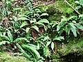
The village stream, which connects the forest with the lake and crosses the built-up village center, is a lifeline and an important basis for local and supra-regional biodiversity and species diversity . With regard to the flora that occurs in Switzerland, the Küsnachter Tobel has a special position. The requirements for the flora of the ravine have changed since the structural measures to protect against floods: Before the creek was built up, the Küsnachter ravine was described as a wild "mountain gorge". On the edges of steep gullies down into the ravine, light, sun-drenched forest with a rich flora has grown between the protruding parts of rock. In the valley of the ravine there are evidence of gray alder trees found on the banks of mountain rivers. On the slopes of the ravine, the goats grazed here kept the undergrowth in check. Field names such as “Zürimoos” or “Aegerten” are reminiscent of the temporary agricultural use of the designated areas. The forest provided the villagers with construction timber and firewood, with middle and coppice forests, for example in the "hazel stalls", periodically providing for open, sunny forest areas. The erosion of the ravine also decreased as a result of the stream construction, whereby its dynamics continue to emerge, as with the fall of the dragon's head . At the same time, the increasingly growing and darkening ravine was forested, in which beeches and extensive planted spruces now predominate.
Today, well-known plants shape the picture in the cultivated areas of the ravine, such as the common worm fern , the common cowslip , wood anemone , the little balsam (“don't touch me”), but also poisonous plants such as the singleberry or the many-flowered Solomon's seal . Typical woody plants include yew trees and holly trees , from which the field name of the Palmeräi (palm rain) located in the ravine is derived. In addition, however, the ravine offers space for particularly rare and protected plants: the rocks made of Nagelfluh gravel and sandstone are overgrown with a rich community of ferns , which include the wall rue , the brown and green-stemmed striped fern and the deer tongue . On steep slopes, where landslides have exposed the marl, relics of the Ice Age have even been preserved in the stone breakwater corridor characteristic of the Küsnachter Tobel . This refers to special plants that are otherwise only known in the Alps, such as the saffron saxifrage , the lashed saxifrage or the Alpenmasslieb . The protected hillside areas and swamp areas are also of importance , for example in the Cholgrueb , the hazel bushes or the renatured Tobelmüli terrain chamber . Rarities are found here, such as the broad-leaved and the flesh-red orchid , flour primrose , student rose , swallow-root gentian and the lung gentian , which is endangered in Europe . In the worth protecting remnants originally bright forest, for example embodied in Wulphügel , extremely be rare species, such as the Red Waldvögelein , the fringed gentian and the lady's slipper , observed. Various nature conservation measures contribute to the continued existence of these unique and precious habitats.
Unwanted neophytes are spreading in the Küsnachter Tobel, among others: the liana honeysuckle (Lonicera henryi), which had spread over a wide area in the entrance of the ravine up until the beginning of 2020, glandular balsam , summer lilac . In the area of the brook delta, the remains of the original lakeshore vegetation are cared for and protected, especially the thinned reeds, among others at the Küsnachter Zehntentrotte .
- Plants in the Küsnachter Tobel
Common worm fern and deer tongue fern

Bird's nest (Neottia nidus-avis) from the orchid family

Angel sweet ( Polypodium vulgare ) on a tree

Swallowwort gentian (Gentiana asclepiadea)

Lashed Saxifrage (Saxifraga aizoides)

Saffron saxifrage (Saxifraga mutata)

Fern, mushrooms and moss

Liana honeysuckle (Lonicera henryi): Overgrown areas in August 2019

Glandular balsam (Impatiens glandulifera)


_als_Epiphyt_auf_Baum.jpg)


,_2019.jpg)

.jpg)

fauna
The Küsnachter Tobel is a habitat for numerous mammals , including deer , foxes , badgers , pine martens , squirrels and dormice . In June 2019 a roaming chamois was in the ravine . Along the village of Bach is different mouse modes can (u. A. Wood mouse , vole ) and rats observed. While the bats (little horseshoe bat ) that were found in the Drachenhöhle until the 1950s have now disappeared, the French Cave below the Forchdenkmal is used by the Foundation for the Protection of Our Bats in Switzerland SSF to release bats found in the wild . The control of 15 bat roosts in the municipal area is subordinate to the nature and bird protection association. Every year in spring, an impressive amphibian hike takes place between the Küsnachter Tobel, the Schübelweiher and the Rumensee .
In the Küsnachter Tobel there is a cantonal distribution center for the gray wagtail and the dipper . The dipper has been affected by a drastic decline since 2016: Compared to 2008 with 18 documented breeding pairs, only three breeding pairs could be confirmed in 2019; the number of young birds hatched annually has decreased from 120 animals to an estimated 10 in 2019. The reasons given for the acutely threatening decrease in dipper populations in the Küsnacht area are:
- the poor water quality of the brook due to the discharge of wastewater from Zumikon
- the pollution of the village stream from agricultural activity in adjacent areas
- Construction work for an additional sewage treatment plant
- the increasing pressure from the heavy use of the ravine as a recreation area, free-roaming dogs, mountain bikers and joggers
The Küsnacht Gorge with its geographical proximity to Rumensee and Schübelweiher among other nesting and refuge for buzzards and herons . The tawny owl is also native here. Numerous observations of gray woodpecker and kingfisher , which can sometimes also be observed in the area of the delta, are documented. A project of the Naturnetz Pfannenstil aims to improve the habitat of the gray woodpeckers as well as reptiles such as the forest lizard and various snail species on the Wulphügel .
The Küsnachter Dorfbach is one of the most important spawning grounds for lake trout on Lake Zurich. However, barriers and barriers had blocked the lake trout's access to the waters of its birth in the upper area of the brook. In 2011 this was partially renatured by installing gutters 0.8 m deep and 2.8 m wide with a funnel-shaped inlet and a forecourt in the bottom three base ramps . These should give the animals an opportunity to climb up even when the water level is low. In 2013, during a spawning attempt, the cantonal fisheries administration found two lake trout over 60 cm long at the village square for the first time. After a collapse in the lake trout stock as a result of the structural measures, it has been gradually increasing again since then. The behavior of the reacting sensitively to environmental influences spawning animals simultaneously pointer type for the water quality are is observed systematically in one since 2005 ongoing monitoring in the Zurich Seezuflüssen and documented.
- Animals in the Küsnachter Tobel

Blue-winged demoiselle

Fire salamander larvae

Common frog tadpole

Endangered population: dipper

Gray wagtail, young bird

Gray heron

Pollution in the ravine

Dirty water foam mushrooms
,_2019.jpg)
,_2019.jpg)
,_Kaulquappe,_2019.jpg)
,_2019.jpg)
,_2019.jpg)
,_2019.jpg)


Attractions
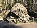
Alexander stone
As a geotope, the Alexanderstein is a valuable natural monument and protected object of cantonal importance . The five meter high boulder made of Taveyannaz sandstone is located in the lower part of the Küsnachter Tobel. With a volume of around 70 m 3 (= approx. 180 t), it was previously called Wöschhüüslistei ( wash house stone ) because of its shape and size . The largest erratic in the Küsnachter Tobel was transported from Hausstock in the Glarus Alps to Lake Zurich around 20,000 years ago during the last Ice Age on the Linth Glacier . At first it lay on a flat wall moraine above the village. When the Küsnacht brook cut the moraine towards the end of the Ice Age, the boulder slipped into the ravine and sank together with the valley floor.
The stone was named by the Küsnachter Verein Wulponia, founded in 1886 . This honored his founding member, the late geologist Alexander Wettstein (1861-1887), who had explored the Küsnachter Tobel. The inscription applied to the rock in white by the Wulponites was replaced in 1966 by a bronze plaque commissioned by the Küsnacht Beautification Association.
On the Alexanderstein grows a special vegetation worthy of protection as a “unique natural phenomenon” , including 48 types of moss alone, of which several rock-dwelling and lime-fleeing species occur only on silicate boulders in the Swiss plateau . The northern striped fern ( Asplenium septentrionale ), which has one of its last locations in the Swiss Plateau, was documented as a peculiarity of the plant diversity of the Küsnachter Tobel in the combined herbaria of the University of Zurich and the ETH Zurich as early as 1822 . It is still unknown whether and to what extent the warmer climate affects this unique vegetation, among other things.

Alexanderstein 2013

2019

Memorial plaque to Alexander Wettstein

Representation by Rudolf Ringger , around 1890

1940, with inscription

.jpg)


Dragon cave
The several meters deep Drachenhöhle (formerly Fledermausstein ) located in the middle part of the Küsnachter Tobel is a witness of its geological origin: It is made up of Nagelfluhfelsen, the strongly cemented Wulp gravel characteristic of this part of the Tobel. Called the “holey Nagelfluh”, the Wulp gravel was first described and mapped in 1885 by Alexander Wettstein. In his opinion, they went back to glacier deposits in a freshwater lake that the glacier had dammed in the pre-glacial Küsnachter Tobel. Albert Heim observed in 1912 and 1919 that the gravel filled a valley that crossed the ravine from southeast to northwest and formed before the last ice age. A study presented in 2012 ultimately assumes that the Linth-Walensee glacier poured out streams of mud into a reservoir near the ice edge, which was temporarily drained. The cementing of the gravel would have intensified , among other things, the inundation of glacial milk.

Drachenhöhle in the area

Entrance in the holey Nagelfluhgestein

.jpg)
Dragon head
The six meter high, 125 m 3 large and approx. 250 ton heavy Nagefluhbrocken fell on April 24, 2013 in a rock fall not far from the Drachenhöhle and came to a standstill between Tobelweg and Bach. Eyewitnesses to the event - Olympic medal winners in the military discipline Rudolf Günthardt and Walter Hohl, long-time swimming instructor for the community - were unharmed. After initial concerns about the fragility of the material, the rock was permanently secured at the request of the population as a monument to the forces of nature that determine the ravine. In a naming competition organized by the Küsnacht Improvement Association , the rock was given the name Drachenkopf, based on the nearby Drachenhöhle.

Reduced and secured dragon head below aisle

Dragon head with characteristic nagelfluh

up the valley
down the valley

Termination point
.jpg)
.jpg)


Wulp ruins
On the south side of the ravine is at Wulphügel the wulp castle . The castle, which dates from the High Middle Ages and was placed under federal protection in 1923, was archaeologically examined in three phases on behalf of the Küsnachter Beautification Association (1920 to 1922, 1960 and 1980 to 1982). The site can be reached from Tobelboden via two steep footpaths.

Castle wall from the outside

Heart well and inner area of the wall

Historical aerial photo (1948 Werner Friedli)
Historic photo of the memorial plaque (1940 Leo Wehrli)


Boulder garden

In the 1970s, at the suggestion of the biology teacher at the Küsnacht seminar Hans Hartmann , the Küsnacht beautification association set up a collection of boulders at the former location of the Decoweiher in the lower area of the ravine . The 65 or so witnesses of the Ice Age, some of which come from the Vorderrheintal , the Walensee Valley , the Glarnerland , the Zürcher Oberland , the Pfannenstiel and the Speer area , and some of them with glacier cut and tectonic sliding surfaces, had previously been collected from various construction pits in Küsnacht. Completed around 1980 with a fountain by the sculptor Thomas Ehrler, the erratic boulder garden, which is also used by children as a natural "rest and playground", has been redesigned in 2011 from 320 million year old granite porphyry to 12 million year old molasse rock according to geological origin and age of the boulders presented.
Floods

Because of its large catchment area of almost 13 square kilometers, the stream collects enormous amounts of water when it rains heavily. The masses of water - mixed with rubble and debris - flow like from a funnel towards the village at the exit of the ravine. This repeatedly led to severe flooding.
Flood 1778
The first well-documented flood disaster occurred on July 8, 1778. After a violent thunderstorm on the western flank of the Pfannenstiel, huge masses of water gathered in the upper reaches of the stream. Less than an hour after the storm began, the floods reached the sleeping Küsnacht around 10 p.m. The tidal wave hit the village unprepared and with tremendous force. It destroyed numerous buildings and killed 63 people.
Flood 1878
A hundred years after the last catastrophe, the Dorfbach flooded its banks again on June 3, 1878. Since the water could not flow under the bridge at Seestrasse, which was too deep in 1838, it flooded the lower part of the village and caused considerable damage. A man drowned.
1946
Another flood occurred on July 14, 1946, when 74 millimeters of rain fell within 90 minutes. The brook caused severe damage to side walls and barriers; People were not harmed. The damage in the Küsnachter Horn area was particularly severe. The weak points that had come to light were eliminated and the walls reinforced.
legend
The constant floods and devastation found their expression in the legend "The dragon from Küsnachter Tobel". The story tells of a dragon who repeatedly breaks out of its cave in the ravine and devours everything it encounters. A knight defeats the ghost with the help of Our Lady, who ties the dragon to the rock with a diamond chain. Meinrad Lienert recounted the legend associated with the dragon cave in Küsnachter Tobel in his collection of Zürcher sagas under the title Der Fledermausstein . Alexander Wettstein made the connection with the geological origin of the ravine:
«In the Nagelfluh with sandy binding agent, caves easily form due to the uneven weatherability. The whole of the Nagelfluh is rich in them. The largest of these is the so-called "Fledermausstein" on the right side of the stream. According to the legend, it used to be the residence of a fierce dragon, which from time to time left the cave to descend to the village of Küsnacht, devastating everything. In this dress the memory of earlier devastation by the brook lives on, memories that were only too vividly refreshed by the floods of 1778 and 1878. »
The Reformed Church of Küsnacht is dedicated to St. George, who is remembered as a dragon slayer (patronage 1332).
Flood protection
To prevent further flooding, extensive flood protection measures were taken.
First stage 1778
As a first measure, the stream was straightened in the area of the village as early as 1778 and channeled into a nine meter wide bed. This was able to prevent floods for 100 years.
Second stage 1880–1890
To prevent congestion, the first thing to do in 1880 was to raise the bridge over the Seestrasse by 60 centimeters. As a result, several barriers were built in the ravine, including several torrent barriers made of dry masonry. Because these measures did not withstand a flood on July 7, 1891, a comprehensive construction of the ravine was decided.
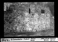
Third stage 1895–1899
In the ravine, a torrent barrier staircase was built with great material and financial expense; Over a hundred barriers made of wood, stone boxes, dry stone walls and concrete were installed. The banks were fortified with stones between the barriers. The largest barrier at the Tobel exit is eight meters high. On average, the gradient of the creek was reduced from 4% to 1–2% over a length of 2.5 kilometers. At the same time, the four largest tributaries were built, and later even smaller tributaries. The work was led by Jean Pfister, who was nicknamed “Bach-Pfister” in Küsnacht.
Fourth stage 1946
After a flood on July 14, 1946, caused severe damage to the creek walls, especially on the Küsnachter Horn, damaged or destroyed barriers in the ravine and flooded cellars and gardens, several walls were reinforced again. Since then, Küsnacht has been spared damage from floods.

Rock bar at the ravine exit in front of the barriers

Same place after the construction


literature
- Dieter Imboden: About mills, robber knights and a Christmas tree. Unterwegs 2019/2020, in: Journal21.ch, December 19, 2019. ( Online )
- Walter Appenzeller, Christoph Schweiss: hiking map Küsnachter Tobel. Local museum. Küsnacht 2002.
- Alfred Egli: The Küsnacht Beautification Association. Biography of a "breastfeeding man in the country". In: Küsnachter Jahrheft 1983, pp. 25–45.
- Hans Frey: In Küsnachter Jahresblätter 1974, pp. 28–39
- Charles Knapp, Maurice Borel, Victor Attinger, Heinrich Brunner, Société neuchâteloise de géographie (editors): Geographical Lexicon of Switzerland . Volume 3: Krailigen - Plentsch . Verlag Gebrüder Attinger, Neuenburg 1905, p. 17, keyword Küsnachterbach ( scan of the lexicon page ).
Web links
- Küsnacht local museum ("Küsnachter Tobel")
- Cantonal inventory for landscape objects (inventory 80)
- Swiss Landscape Protection Foundation
Individual evidence
- ^ Charles Knapp, Maurice Borel, Victor Attinger, Heinrich Brunner, Société neuchâteloise de geographie (editor): Geographical Lexicon of Switzerland . Volume 3: Krailigen - Plentsch . Verlag Gebrüder Attinger, Neuenburg 1905, p. 17, keyword Küsnachterbach ( scan of the lexicon page ).
- ↑ a b Dorfbach Küsnacht in front of Lake Zurich. (PDF; 122 kB) Position 432: monthly samples. In: Office for Waste, Water, Energy and Air, Department of Water Protection. Retrieved April 21, 2013 .
- ↑ René Hantke: On the geology of the Küsnachter Tobels. The molasses deposits of the pan handle chain . In: Küsnachter annual magazine . 1993, p. 89-98 .
- ↑ Alexander Wettstein: Geology of Zurich and the surrounding area. With a geological map and a blackboard. J. Huber's Buchdruckerei, Frauenfeld 1885, p. 42 .
- ↑ René Hantke: On the geology of the Küsnachter Tobels . In: Küsnachter annual magazine . 1993, p. 89-98 .
- ↑ Swiss Federal Archives SFA: Switzerland is drilling for oil, May 1960. Retrieved on September 22, 2019 .
- ↑ Dominik Letsch: The Wulp gravel in the Küsnachter Tobel . (Continued in: Küsnachter Annual Issue 2007). In: Küsnachter yearbook 2006 . 2006, p. 79-85 .
- ^ Heinrich Flach: Küsnacht am Zürichsee. Excursions from Lake Zurich to Lake Greifensee. Zurich, [sn], 1900 . In: Küsnachter annual magazine . No. 6 , 1966, pp. 37-38 .
- ^ Hans Gattiker: village chronicle . In: Küsnachter annual magazine . 1961, p. 39-47, cit. 40 .
- ↑ Tobelbrücken vote resulted in a large parade at the Küsnacht community assembly . In: Zürichsee-Zeitung . June 23, 1971.
- ^ Hans Schnider: Village chronicle about the year 1971 . In: Küsnachter annual magazine . S. 80-90, especially 80 .
- ↑ hbi .: The rejection of the Tobelbrücke in Küsnacht . In: Neue Zürcher Zeitung . 288 (noon edition), June 24, 1971, p. 19 .
- ↑ Tim Frei: Boulders in Küsnachter Tobel moved with heavy equipment . In: Tages-Anzeiger . June 17, 2011, ISSN 1422-9994 ( tagesanzeiger.ch [accessed on August 26, 2019]).
- ↑ Nature trails - Küsnacht Improvement Association. Retrieved on August 26, 2019 (German).
- ↑ Fabienne Sennhauser: When the right bank of the lake was supposed to get an expressway. In: Zürichsee-Zeitung . September 16, 2019, p. 6 .
- ↑ Franziska Grossenbacher: No suspension bridge over the Küsnachter Tobel (media release) . Ed .: Foundation for Landscape Protection Switzerland. November 9, 2018.
- ↑ Manuela Moser: The "bridge builder" is no longer . In: Küsnachter. Local newspaper for Zumikon, Erlenbach, Zollikon, Zollikerberg, Forch and Herrliberg . No. 4 , January 24, 2019, p. 1 .
- ↑ Municipality of Küsnacht (ed.): Partial revision of the municipal structure plan for traffic / pedestrian bridge Küsnachter Tobel / Explanatory report according to Art. 47 of the spatial planning ordinance. Version dated December 13, 2017 for public circulation, preliminary examination and hearing .
- ↑ Annina Just: Küsnacht: The next court will judge the Tobel Bridge . In: Zürichsee-Zeitung . 17th September 2019.
- ↑ Suspension bridge over Tobel in Küsnacht: new report required. Retrieved June 30, 2020 .
- ↑ Federal Office for the Environment FOEN: Biodiversity in Swiss Forests. Retrieved October 26, 2019 .
- ↑ Rolf Holderegger and Lea Wirth: The flora of the Küsnacht community and its changes over the past two centuries . In: Küsnachter annual magazine . 2017, p. 34-50 .
- ^ Rolf Holderegger: On the flora and vegetation of the Küsnachtertobel: Changes within the last fifty years . In: Botanica Helvetica . No. 104 , 1994, pp. 55-68 .
- ^ Alfred Egli: The place, water and field names of our community (IV) . In: Küsnachter annual magazine . 1982, p. 3-21 .
- ↑ Jonas Hoehn: Lost on Lake Zurich: Gamsbock sighted in Küsnacht . In: Zürichseezeitung . June 21, 2019.
- ↑ Rolf Holderegger: Of dwarfs and long ears: Küsnacht's bats . In: Küsnachter annual magazine . 1996, p. 106-118 .
- ↑ Annual report of the Nature and Bird Protection Association Küsnacht (Nvvk) for the association year 2018 .
- ↑ Philippa Schmidt / Tim Haag: Warnings have been given, not hiked yet . In: Zürichseezeitung . February 8, 2018.
- ↑ David Herter: The barrier guard from the Schübelweiher . In: Zürichseezeitung . 1st March 2018.
- ^ Johann Hegelbach: The dipper . In: Küsnachter annual magazine . 1993, p. 59-72 .
- ↑ Dippers are disappearing from the Küsnachter Tobel. In: Zürichsee-Zeitung. August 9, 2019, accessed August 25, 2019 .
- ↑ Inventory of nature and landscape protection objects of supra-municipal importance . 1979.
- ↑ BirdLife Zurich: BirdLife Zurich - Küsnacht - biodiversity, biodiversity, nature conservation, species protection, nature conservation organization, nature conservation association. Retrieved on August 25, 2019 (Swiss Standard German).
- ^ Wulp (Küsnacht). Retrieved September 1, 2019 .
- ↑ Lake trout management in the canton of Zurich Concept 2010–2018. (PDF; 876 kB) (No longer available online.) Fisheries and Hunting Administration of the Canton of Zurich, archived from the original on January 8, 2017 ; Retrieved April 21, 2013 .
- ^ Walter Bernet: A way to the spawning grounds. In: Neue Zürcher Zeitung . August 13, 2011, accessed April 21, 2013 .
- ↑ (dp): From the municipal council. Lake trout rise . In: Dorfpost . No. 295 , December 11, 2013, p. 4 .
- ↑ Canton of Zurich, Building Directorate, Office for Landscape and Nature Fisheries and Hunting Administration: Temporary ban on fishing at the mouth of the streams of Lake Zurich - protective measures in favor of the lake trout stocks. October 25, 2019, accessed on January 17, 2019 (German).
- ^ Andreas Hertig: Monitoring of lake trout spawning animals in small lake tributaries . In: WasserWirtschaft . No. 2–3 , 2019, pp. 19-22 .
- ↑ Erratics Alexanderstein. (No longer available online.) In: Erratiker.ch. Archived from the original on September 24, 2015 ; accessed on August 23, 2015 .
- ^ Alfred Egli: The Küsnacht embellishment association . In: Küsnachter annual magazine . 1983, p. 25-45 (p. 41) .
- ↑ Daniel Hepenstrick, Edi Urmi, Markus K. Meier and Ariel Bergamini: The moss flora of the silicate foundling Alexander Stein in Küsnacht (ZH) . In: Meylania . tape 57 , 2016, p. 15-23 (citation p. 16) .
- ↑ René Hantke: On the geology of the Küsnachter Tobels: the molasse deposits of the Pfannenstiel chain . In: Küsnachter annual magazine . 1993, p. 89-98 .
- ↑ Alexander Wettstein: Geology of Zurich and the surrounding area . Wurster, Zurich 1885.
- ^ Heim, Albert: Geology of Switzerland. Volume 1 Molasseland and Jura Mountains . Tauchnitz, Leipzig 1919.
- ↑ Dominik Letsch: attempt to interpret a complex valley filling near the ice edge: the Wulp gravel and its glacial environment . In: Swiss bulletin for applied geology = Swiss bulletin pour la géologie appliquée = Swiss bulletin per la geologia applicata = Swiss bulletin for applied geology . tape 17 , no. 1 , 2012, p. 61-76 .
- ↑ Rock fall in the Küsnachter Tobel | NZZ . April 24, 2013, ISSN 0376-6829 ( nzz.ch [accessed September 1, 2019]).
- ↑ Zurich Schaffhausen - Will the rock stay in the Küsnachter Tobel? June 11, 2013, accessed September 1, 2019 .
- ↑ Zurich Schaffhausen - horror in the Küsnachter Tobel - a year later. April 24, 2014, accessed September 1, 2019 .
- ↑ Bettina Zanni: How the dragon lost its head . In: Zürichsee-Zeitung . 11th. November.2013.
- ^ Christian Bader: The Wulp castle ruins near Küsnacht ZH (= Swiss contributions to the cultural history and archeology of the Middle Ages ). Schweizerischer Burgenverein, Basel 1998, ISBN 978-3-908182-09-2 ( rero.ch [accessed on September 22, 2019]).
- ↑ Portrait / Historical Review - Küsnacht Beautification Association. Retrieved September 3, 2019 (German).
- ^ Claudia Benetti: Geological phenomena in Tobel Küsnacht . In: Küsnachter . June 23, 2011.
- ↑ Tim Frei: Boulders in Küsnachter Tobel moved with heavy equipment . In: Tages-Anzeiger . June 17, 2011, ISSN 1422-9994 ( tagesanzeiger.ch [accessed on September 3, 2019]).
- ^ Beautification Association Küsnacht: Brochure Foundlingsgarten and Geological Educational Trail. Retrieved September 3, 2019 .
- ↑ Meinrad Lienert: Zurich legends . Ed .: Tanja Alexa Holzer. Wortfeger, Siebnen 2013.
- ↑ Alexander Wettstein: Geology of Zurich and the surrounding area. With a geological map and a blackboard . J. Huber's Buchdruckerei, Frauenfeld 1885, p. 76 .