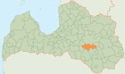
Krustpils district
| Krustpils district | |||
|---|---|---|---|
 |
|||
| Symbols | |||
|
|||
| Basic data | |||
| Country | Latvia | ||
| Capital | Krustpils | ||
| surface | 812.2 km² | ||
| Residents | 6680 (2010) | ||
| density | 8.2 inhabitants per km² | ||
| ISO 3166-2 | LV-049 | ||
| Website | www.krustpils.lv (Latvian) | ||
Coordinates: 56 ° 35 ' N , 25 ° 55' E
The Krustpils District (Krustpils novads) is located in southeastern Latvia in the Latgale region .
geography
The area is northeast of the Daugava and south of the Aiviekste . It is dominated by agriculture.
population
The district consists of the six parishes (pagasts) Atašiene, Kūka, Mežāre, Varieši, Vīpe and Krustpils. The administration building is located in the Krustpils district of the "Republic City " of Jēkabpils , which itself does not belong to the district. 6680 inhabitants (2010) live in the Krustpils district.
Web links
Commons : Krustpils district - collection of pictures, videos and audio files

