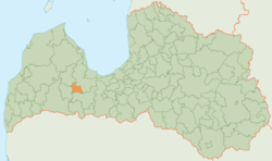
Jaunpils district
| Jaunpils district | ||
|---|---|---|
 |
||
| Symbols | ||
|
||
| Basic data | ||
| Country | Latvia | |
| Capital | Jaunpils | |
| surface | 210.2 km² | |
| Residents | 2678 (2013) | |
| density | 13 inhabitants per km² | |
| founding | 2009 | |
| ISO 3166-2 | LV-040 | |
| Website | www.jaunpils.lv (Latvian) | |
| Jaunpils | ||
Coordinates: 56 ° 44 ' N , 23 ° 1' E
The Jaunpils District (Jaunpils novads) is located in western Latvia in the historical Kurzeme countryside .
geography
The eastern border of the rural area is formed by the Abava . Many streams and ditches run in the lowlands.
population
The district consists of the two municipalities ( pagasts ) Viesati and the administrative center Jaunpils . 2678 inhabitants (2013) live in the Jaunpils district.
Web link
Individual evidence
- ↑ http://www.jaunpils.lv/municipality.php Jaunpils Municipality

