Aknīste district
| Aknīste district | ||
|---|---|---|
 |
||
| Symbols | ||
|
||
| Basic data | ||
| Country | Latvia | |
| Capital | Aknīste | |
| surface | 285 km² | |
| Residents | 3236 (2010) | |
| density | 11 inhabitants per km² | |
| founding | 2009 | |
| ISO 3166-2 | LV-004 | |
| Website | www.akniste.lv (Latvian) | |
| Landscape in Aknīste | ||
Coordinates: 56 ° 10 ' N , 25 ° 46' E
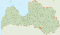
The District Aknīste (Aknīstes novads) is in the south of Latvia on the border with Lithuania in the historic landscape Sēlija .
geography
The Dienvidsusēja flows through the rural area . The southern border is also the state border with Lithuania.
Administrative division and population
The district consists of the three parishes (pagasts) Asare, Gārsene and Aknīste (Land) and the administrative center Aknīste . 3236 inhabitants (2010) live in Aknīste district.
Web links
Commons : Aknīste Municipality - Collection of images, videos and audio files

