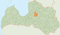
Amata district
| Amata district | ||
|---|---|---|
 |
||
| Symbols | ||
|
||
| Basic data | ||
| Country | Latvia | |
| Capital | Amata | |
| surface | 741.8 km² | |
| Residents | 6357 (2010) | |
| density | 8.6 inhabitants per km² | |
| founding | 2009 | |
| ISO 3166-2 | LV-008 | |
| Website | www.amatasnovads.lv (Latvian) | |
Coordinates: 57 ° 9 ′ N , 25 ° 19 ′ E
The Amata District (Amatas novads) is located in the center of Latvia in the historical Vidzeme countryside .
geography
The Riga-Pleskau road and the Amata river run through the rural area . The Gauja forms part of the northern border. At Āraiši , a prehistoric settlement made of stilt houses has been restored.
population
The district consists of the four municipalities (pagasts) Drabeši , Nītaure , Skujene , Zaube and the administrative center Amata . 6357 inhabitants (as of 2010) live in the Amata district.
Web links
Commons : Amata Municipality - Collection of images, videos and audio files
