
List of mountains and elevations in Wuppertal

The list of mountains and elevations in Wuppertal shows a selection of mountains and elevations as well as their foothills in the urban area of Wuppertal - sorted by height in meters (m) above sea level (NHN).
Mountains and elevations
The following table shows a selection of Wuppertal mountains and elevations. The highest elevation is the Lichtscheid (350 m), followed by the Ehrenberg (345 m), which is also the highest halfway unspoilt mountain in Wuppertal, and the Hahnerberg (330 m).
- No .: Indicates the order of the mountains and elevations according to height.
- Name: name of the mountain; second line with possible alternative names
- Height: Height in meters (m) above mean sea level (NHN)
- Municipality: Name of the municipality in which the mountain is (for the most part).
- Location: Next associated location / residential area.
- Natural area: Specification of the natural spatial order units. (→ see also: List of natural units in North Rhine-Westphalia )
- Special: sights and attractions Ä., which can be found directly on the mountain.

Relief Wuppertal with a selection of mountains

3D model of the Wuppertal elevations

The table sorted by height in the initial view can be sorted by clicking on the symbols next to the column headings.

.jpg)


-2.JPG)


Rock formations
There are also some rock formations in the urban area. Two of them are protected as natural monuments: the Hohenstein (a dolomite rock cliff) and the Flinzschiefer Scholle .
| Surname | Height (m) | district | location | Natural space | Special | image |
|---|---|---|---|---|---|---|
| Flinzschiefer plaice | 191 | Elberfeld | Nevigeser Strasse | Hasslinghauser back |

|
|
| Hohenstein | 162 | Barmen | Red | Barmer limestone sink | Hohenstein Park |

|
gallery

Ehrenberg (345 m) seen from the Scharpenacker Berg
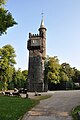
Summit of the Nützenberg (260 m) with the Weyerbuschturm

Hardt with Elisenturm and botanical garden

Historic town hall on the Johannisberg (172 m)
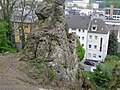
Hohenstein from the north


Web links
- Geography Giersbeck: Maps, sheet 109 - Düsseldorf-Erkelenz , overview of natural areas in Wuppertal and the surrounding area