Lurnfeld
|
market community Lurnfeld
|
||
|---|---|---|
| coat of arms | Austria map | |
|
|
||
| Basic data | ||
| Country: | Austria | |
| State : | Carinthia | |
| Political District : | Spittal an der Drau | |
| License plate : | SP | |
| Main town : | Möllbrücke | |
| Surface: | 33 km² | |
| Coordinates : | 46 ° 50 ' N , 13 ° 22' E | |
| Height : | 557 m above sea level A. | |
| Residents : | 2,679 (January 1, 2020) | |
| Population density : | 81 inhabitants per km² | |
| Postcodes : | 9813, 9812 | |
| Area code : | 04769 | |
| Community code : | 2 06 43 | |
| NUTS region | AT212 | |
| Address of the municipal administration: |
Hauptstrasse 2 9813 Lurnfeld |
|
| Website: | ||
| politics | ||
| Mayor : | Gerald Preimel ( SPÖ ) | |
|
Municipal Council : ( 2015 ) (19 members) |
||
| Location of Lurnfeld in the Spittal an der Drau district | ||
| Source: Municipal data from Statistics Austria | ||
Lurnfeld is a market town in the Spittal an der Drau district in Carinthia in Austria , with 2,679 inhabitants (as of January 1, 2020).
geography
Geographical location
Lurnfeld is a large municipality and is located on the western edge of the basin landscape of the same name at the end of the upper Drau valley . The capital Möllbrücke is located at the confluence of the Möll in the Drau , a few kilometers west of Spittal an der Drau . The Kreuzeck group rising in the west of the municipality separates the Mölltal from the upper Drautal.
Community structure
The market community is divided into four cadastral communities : Möllbrücke I, Möllbrücke II, Möllbrücke III and Pusarnitz.
The municipality includes the following 13 localities (population in brackets as of January 1, 2020):
- Altenmarkt (66)
- Drauhofen (4)
- Goeriach (291)
- Metnitz (39)
- Möll Bridge (1246)
- Pattendorf (209)
- Premersdorf (45)
- Pusarnitz (521)
- St. Gertraud (24)
- St. Stefan (4)
- Steindorf (173)
- Stöcklern (41)
- Trobach (16)
Neighboring communities
| Mühldorf |

|
Lendorf |
| Sachsenburg | Baldramsdorf |
history
The vallis Lurna was mentioned at the time of the Romans in Carinthia, and the Lurnfeld has been known in documents since 891 (as Liburnia ).
The village of Möllbrücke was first mentioned as mölnprukke in a document from 1253 and was the seat of a regional court of the Counts of Görz from 1307 at the latest .
Pusarnitz, first mentioned in a document in 1072, obtained through the Peace of Pusarnitz , which in 1460 the disputes between Emperor Friedrich III. and Count Johann von Görz to the county of Cilli ended, supra-regional importance. While the neighboring Sachsenburg had developed into an important market town as early as the 13th century, Möllbrücke gained supraregional importance primarily through a brass factory that existed from around 1597 to 1775.
In August 1825, the Viennese alpinist and court chamber official Josef Kyselak (1798–1831) arrived in Möllbrücke on his Austria hike from Lendorf. He wrote: “In half an hour you can reach Möllbrücke on the road - just a few houses where a little below the Möll flows into the Drau. The road to Tyrol leads over the bridge through Altenmarkt, on this side on the left bank of the roaring Möll, to Salzburg. On the bridge, some memorial plaques show some accidents that this irrepressible nymph often wages in anger. Houses were swept away, trucks and coachmen buried in the floods, etc., one should become an enemy against this mighty Alpine daughter against her will, and yet one is happy to hike up to the picturesque granite valley in her contemplation. "
When local congregations were formed in 1850, next to the old market town of Sachsenburg, the municipality of Pusarnitz was formed in what is now the municipality.It was incorporated into Sachsenburg in 1865, but became independent again in 1889 - together with the village of Möllbrücke. In 1909 Möllbrücke split off from the municipality of Pusarnitz. The three municipalities of Sachsenburg, Möllbrücke and Pusarnitz were merged during the municipal structural reform in 1973 to form the new large municipality of Lurnfeld, from which Sachsenburg became independent again after a referendum in 1992.
population
At the time of the 2001 census, Lurnfeld had 2,718 inhabitants, 85.4% of whom were Austrian citizens . 82.2% of the population professed the Roman Catholic Church , 7.8% the Evangelical Church and 1.1% Islam . 6.4% of the population were without religious beliefs.
Culture and sights
Pilgrimage Church of Maria in Hohenburg
High above the wide valley floor of the Lurnfeld between Spittal an der Drau and Möllbrücke , at 974 m above sea level, on the sunny side, lies a small white church, the Church of Maria in Hohenburg .
The little castle chapel had almost the same fate as the Hohenburg above it. With the erection of a statue of the Virgin Mary from Altötting in 1706, the old castle chapel became the Marienkirche Hohenburg. The oldest parts, the chancel and the south portal, date from the Carolingian era.
In 1714, when the chapel was enlarged, a high altar with a beautiful lattice was erected in front of it. In 1776 the church was extended to the west by blasting off the rock, and a higher tower and the choir were built. In order to cope better with the expected flow of visitors for the 250th anniversary of the pilgrimage church, the connecting piece from Hirschbergstraße to Hohenburg was expanded in 1956.
The panoramic view from the forecourt of the church includes the Millstätter See , the Nockberge , Spittal an der Drau, the lower Drautal to the Mittagskogel near Villach, the Karawanken , the Goldeck , Latschur , Reisskofel , the Kreuzeck group , and the Salzkofel up to the Mallnitz Tauern .
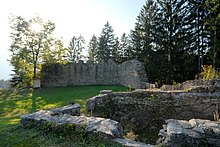
Hohenburg ruins
A vertically sloping rock rises above the church, on which the remains of the wall of the former Hohenburg, the seat of the Counts of Lurn, who administered the Lurngau , can still be admired. The last count of this family died as bishop of Trent as early as 1149. The castle came into the possession of the Salzburg bishops , the rest of the county of Lurn was divided between the Gorizia and Ortenburg noble houses. The steep ascent was probably too difficult for the Salzburgers, they built Feldsberg Castle in the valley (ruins west of Pusarnitz); the Hohenburg was doomed to decay.
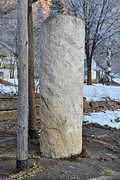
Roman milestone in Möllbrücke
The milestone from the year 218 AD was found in the construction of the staff house of the Carinthian wood industry FX Wirth in 1944. The site is exactly one Roman mile or 7.5 kilometers from Teurnia.
The installation of the stone was carried out by the Austrian Drau power plants and the market town of Lurnfeld. The installation site is on the site of the Möllbrücke hydropower plant, about 100 meters from the site. The stone is owned by FX Wirth.
Other structures
- Feldsberg castle ruins west of Pusarnitz
- Church of St. Leonhard in Möllbrücke, first mentioned in 1234, fortified church in late Gothic style
- Zoggermühle in Stöcklern
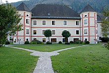
- Drauhofen Castle
- Church of St. Michael in Pusarnitz, built around 1000 years ago, fortified church in Gothic style
politics
City council and mayor
The municipal council of Lurnfeld has 19 members and has been composed as follows since the municipal council election in 2015 :
After the resignation of Mayor Rudolf Hartlieb, Vice Mayor Josef Stanitznig and GR Rudolf Hartlieb Jun. (All 3 FPÖ, formerly FPK and BZÖ), a mayor election took place on August 25, 2013, from which Gerald Preimel (SPÖ) emerged as the winner.
coat of arms
On November 30, 1983, the municipality received the right to carry a coat of arms and a flag with the following description:
- “A golden drawbar in blue, covered with a golden arch bridge, the middle arch of which is entirely visible. The flag shows the colors blue-gold with an incorporated coat of arms. "
The drawbar and bridge symbolize the confluence of the Möll and Drau rivers as well as trade and traffic on the historic bridge. The colors blue and yellow are derived from the old Sachsenburg coat of arms, since Sachsenburg was still part of the market town of Lurnfeld at the time the coat of arms was awarded.
Personalities
Sons and daughters of the church
- Wolfgang Thaler (* 1958), cameraman, director
- Christian Schmölzer (* 1968), sports manager
Personalities associated with Lurnfeld
- Horst Pirker (* 1959), manager
Web links
- Market town of Lurnfeld
- 20643 - Lurnfeld. Community data, Statistics Austria .
Individual evidence
- ↑ Statistics Austria: Population on January 1st, 2020 by locality (area status on January 1st, 2020) , ( CSV )
- ↑ Möllthal. In: Kyselak : Sketches of a foot trip through Austria. Edited by Gabriele Goffriller and with a foreword by Gabriele Goffriller and Chico Klein. Jung and Jung, Salzburg et al. 2009, ISBN 978-3-902497-52-9 , p. 129.
- ^ Statistics Austria, population census, demographic data. May 15, 2001, accessed March 3, 2019 .
- ↑ Announcement of the municipal electoral authority of August 26, 2013 (PDF; 270 kB)


