Mālpils district
| Mālpils district | ||
|---|---|---|
 |
||
| Symbols | ||
|
||
| Basic data | ||
| Country | Latvia | |
| Capital | Mālpils | |
| surface | 220.9 km² | |
| Residents | 4039 (2009) | |
| density | 18 inhabitants per km² | |
| founding | 2009 | |
| ISO 3166-2 | LV-061 | |
| Website | www.malpils.lv (Latvian) | |
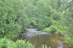
| On the Mergupe River | ||
Coordinates: 57 ° 1 ' N , 27 ° 58' E
The district of Mālpils (Mālpils novads) is located in Latvia .
geography
The district area is in the center of the country. The Mergupe and Suda rivers converge in the district to form the great Jugla . On the 220.9 km² territory there are several wetlands with more than 1000 hectares.
population
The municipality of Mālpils has been known as Mālpils novads since 2009 as part of an administrative reform without changing the territory. In addition to the main town, there are the villages of Sidgunda (459 inhabitants), Upmalas (157 inhabitants), Vite (52 inhabitants) and Bukas (39 inhabitants) in the district. The remaining of the 4039 inhabitants (as of 2009) live on individual farms or in smaller settlements.
Web links
Commons : Mālpils Municipality - Collection of images, videos and audio files

