Ontario Highway 401
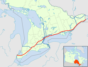
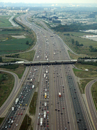
The Highway 401 or Macdonald-Cartier Freeway is a freeway running through the south of the Canadian province of Ontario draws. It's by far the longest 400 series freeway in Ontario and one of the busiest freeways in the world. It has 18 lanes at its widest point. Together with Autoroute 20 in Québec , it forms the main transportation network of the Québec-Windsor Corridor , the most densely populated, affluent and mostly industrialized region of the country, stretching along the Saint Lawrence River and home to over half of Canada's population and three of Canada's largest cities, namely Québec, Montreal and Toronto , are located.
In 1965 the Prime Minister of Ontario, John Robarts , named Highway 401 in honor of the two fathers of the Confederation , Sir John Macdonald and Sir George-Étienne Cartier Macdonald-Cartier Freeway . This is the name used in official documents, but is rarely used on street signs or in conversations.
Route
The highway begins on Highway 3 , which leads over the Ambassador Bridge to Detroit . As part of a new construction project, the highway is being brought up to the Detroit River and is to be extended to the United States , where a connection to Interstate 75 is being created . The highway runs around the town of Windsor , it runs in an easterly direction parallel to the shores of Lake St. Clair , which is 5 km north of the road, then in a northeast direction parallel to the shores of Lake Erie . Along this section are the cities of Chatham and London . This section has up to approx. 25,000 road users. Coming from the west, Highway 402 meets the route, from there the number of users doubles, the highway widens from four to six lanes. At Woodstock , Highway 403 branches off in an easterly direction , which leads to Lake Ontario .
The route now leads to the greater Toronto area . This section is one of the busiest roads in the world, with over 400,000 vehicles per day on the route, which is up to 20 lanes wide, and individual studies even speak of up to 500,000 vehicles. In the greater Toronto area, several highways cross, which connect the surrounding area or the province with Toronto . Just north of Mississauga is the Toronto Pearson International Airport . The highway runs north past the city center and from there arrives at the shores of Lake Ontario. Before the highway then heads east parallel to the lake shore and then follows the Saint Lawrence River , it passes the Rouge National Urban Park . On the St. Lawrence River it then also passes the Thousand Islands National Park . East of Cornwall , the highway meets the provincial border with Québec and continues from there as AutoRoute 20 to Montréal .
There are 18 rest areas along the route . At the Ivy Lea rest stop , where the Highway was completed in 1965, a plaque reminds that Highway 401 is the longest toll-free highway in North America under a single highway administration. However, the Texas section of Interstate 10 now holds this record .
history
The predecessors of Highway 401 were a variety of hiking trails that were created during the colonization of Ontario or were used by the indigenous people who lived there. In 1793 it was decided to build the Governor's Road , it had a length of 20 miles (approx. 32 km). The construction was rewarded with $ 90 per mile. The route ran from Dundas , which was still called Coote's Paradise at the time, to the then capital York , which is now a district of Toronto. The route was expanded and was named The Kingston Road .
The road network in Ontario was supplemented in the following years and there was a connection to Québec , thus connecting the cities of Toronto and Montréal; a postal connection developed between the cities. The emergence of motorization at the beginning of the 20th century made a new expansion necessary, the Toronto-Hamilton Highway was planned and then opened in November 1917. This resulted in Highway 2 , which can be seen as the predecessor of Highway 401.
Thomas McQuesten, the minister in charge of the Department of Highways, developed a new road concept for the province from 1935 onwards. Inspired by the German autobahns , a new type of road was planned which, like the autobahns, consisted of two-lane, structurally separate directional strips. State Secretary Robert Melville Smith took over the planning and adapted the concept of the motorway to Canadian conditions. The first construction phases in this construction method were created on Highway 10 . The first complete highway in this design was the Queen Elizabeth Way , which opened in August 1940. Due to the war, further expansion was halted, but was resumed after its end. The section between Highland Creek and Oshawa was completed in December 1947. The next upcoming section was between Barrie and Toronto, but there were further delays due to the Korean War , so this section was not completed until 1952. At the beginning of the 1950s, the numbers were also assigned, but this led to resistance in the press. In the years that followed, the highway was expanded to the east and west, and some of the existing highways were integrated and expanded, including Highway 27 . The maximum speed was set at 60 mph (miles per hour).
The following years were determined by the further expansion to Windsor in the west and to the border with Québec . The last section was opened in 1968, a plaque near Brockville reminds of it.
So far the highway has only been expanded to four lanes, but as early as 1962 the then Minister of Transport Charles MacNaughton presented ideas to expand the highway near Toronto to at least twelve lanes. This was decided relatively quickly and implementation began; construction was delayed, however, so the project was not completed until 1972. In the 1970s, even against the backdrop of the oil crisis , no significant expansion was carried out. Connections to the feeder highways to Toronto were built, but no further measures were taken. In the 1980s the traffic increased again, so in some areas up to 300,000 vehicles were counted per day, which led to a further expansion.
expansion
In 2004, the governments of the United States and Canada decided to further expand Highway 401. A new bridge south of Windsor, the Gordie Howie International Bridge , will connect the Highway with Highway 85. To the east of the new bridge, a large border checkpoint was to be built on the Canadian side, and the US counterpart on the west side of the Detroit River. The project was named Rt. Hon. Herb Gray Parkway , in honor of longtime MP and Minister Herb Gray . Construction began in August 2011 and is expected to be completed by 2019; project costs of Can $ 1.4 billion have been estimated.
Highway of Heroes
Part of the highway officially bears the name Highway of Heroes ( French Autoroute des héros ). The highway received this addition, since since 2002 all Canadian soldiers who have fallen in Afghanistan have been transferred from the country of deployment back to Canada to the CFB Trenton . From Trenton, the dead are then taken along the highway to the coroner's office at the Center for Forensic Sciences in Toronto . During these overpasses, the streets and bridges are regularly lined with dense crowds to pay their respects to the fallen. The name can be traced back to a report in the Toronto Sun on June 23, 2007. This report was followed by a collection of signatures and a successful petition with the aim of making this designation an official name.
Web links
Individual evidence
- ↑ a b Provincial Highways Traffic Volumes 2012 ( English , PDF) Ontario Ministry of Transportation. May 4, 2016. Archived from the original on September 2, 2016. Info: The archive link was inserted automatically and has not yet been checked. Please check the original and archive link according to the instructions and then remove this notice. Retrieved September 2, 2016.
- ^ Hanna Maier: Long-Life Concrete Pavements in Europe and Canada ( English ) Federal Highway Administration. October 9, 2007. Retrieved September 2, 2016.
- ↑ Shragge, John; Bagnato, Sharon: From Footpaths to Freeways . Ed .: Ontario Ministry of Transportation and Communications, Historical Committee. 1984, ISBN 0-7743-9388-2 , pp. 11 (English).
- ↑ Milton Watson, RR Chapman, FC Biehl [1938]: Saga of a city: 330 years of progress in Hamilton . Hamilton Board of Education, 1947.
- ^ The BMO Legacy. (PDF) BMO Financial Group, p. 2 , accessed on September 2, 2016 (History of the Bank of Montréal).
- ↑ Toronto – Hamilton Highway Proposed . In: The Toronto World , January 22, 1914, p. 14. Retrieved September 2, 2016.
- ^ Stamp, Robert M .: QEW - Canada's First Superhighway . Ed .: Boston Mills Press, Erin, Ontario. 1987, ISBN 0-919783-84-8 , pp. 19th f . (English).
- ^ Stamp, Robert M .: QEW - Canada's First Superhighway . Ed .: Boston Mills Press, Erin, Ontario. 1987, ISBN 0-919783-84-8 , pp. 31 (English).
- ↑ Shragge, John; Bagnato, Sharon: From Footpaths to Freeways . Ed .: Ontario Ministry of Transportation and Communications, Historical Committee. 1984, ISBN 0-7743-9388-2 , pp. 93 f . (English).
- ^ Charles J. Woodsworth: Tasteless Names For Ontario Roads . In: The Evening Citizen , Southam Newspapers, October 17, 1952, p. 40. Retrieved September 2, 2016.
- ↑ a b Speed Limit In Ontario Now At 60 . In: The Ottawa Citizen , Southam Newspapers, May 29, 1959, p. 23. Retrieved March 25, 2010.
- ↑ John G. Shragge: Highway 401 - The Story. Archived from the original on December 24, 2007 ; accessed on September 2, 2016 .
- ↑ The Rt. Hon. Herb Gray Parkway. Ontario Ministry of Transportation, accessed September 2, 2016 .
- ^ Ground breaks on Windsor-Essex Parkway. Accessed September 2, 2016 .
- ↑ Promenade Rt. Hon. Herb Gray Parkway. Accessed September 2, 2016 .
- ^ Stretch of 401 to be renamed 'Highway of Heroes'. CTV , August 24, 2007, accessed July 25, 2014 .


