
Marlborough District
| Marlborough District | |
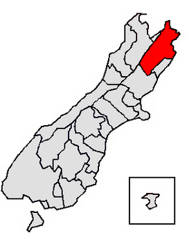
| Geographical location | |
  |
|
| Photo from Marlborough District | |
 The Marlborough Sounds |
|
| Local authority | |
| Country | New Zealand |
| island | South island |
| Local authority | Unitary Authority |
| Council | Marlborough District Council |
| Headquarters of the administration | Blenheim (New Zealand) |
| founding | July 1992 |
| Telephone code | +64 (0) 3 |
| Website | www.marlborough.govt.nz |
| geography | |
| Region ISO | NZ-MBH |
| Coordinates | 41 ° 31 ′ S , 173 ° 58 ′ E |
| surface | 10 458 km 2 |
| Residents | 43 416 (2013) |
| Population density | 4.15 inhabitants per km 2 |
| Statistical data | |
| Public revenue | NZ $ 97.9 million (2015) |
| Public expenditure | NZ $ 95.5 million (2015) |
| Number of households | 22nd 269 (2013) |
| Ø income | NZ $ 27,900 (2013) |
| Māori population | 11.0% (2013) |
The Marlborough District is an administrative unit on the South Island of New Zealand . The district council, called Marlborough District Council , is based in the city of Blenheim . The district has the status of a unitary authority , since it performs the administrative tasks of a region at the same time with its administration, whereby the boundaries of the region are congruent with those of the district.
geography
Geographical location
The Marlborough District has a pure land area of 10,458 km² and had a population density of 4.2 people per km² at the census in 2013 with 43,416 inhabitants. The district is located in the northeastern part of the South Island with access to the Cook Strait . To the west is the Tasman District and the metropolitan area of Nelson City . In the south and southwest, this is done by the Hurunui District , which already belongs to the Canterbury region , and in the southeast is the Kaikoura District . The northern and northeastern part of the district is bounded by the coastline to the Cook Strait .
Except for the plain of the Wairau River , the entire district is characterized by a mountain landscape that is around 1600 m to 1800 m in the west and rises to over 2800 m in the east . The Inland Kaikoura Range should be mentioned as an important mountain range . In the northwest of the district, the Richmond Range stand out particularly. The two largest rivers in the district, Wairau River and Awatere River, are oriented in their direction of flow to the northeast.
The largest city in the district is Blenheim with around 24,200 inhabitants, followed by Picton with around 2,750 inhabitants. All other localities are below 1000 inhabitants.
climate
The Marlborough District is more often under the influence of eastward migrating anticyclones , whereby the prevailing wind directions in the district are not uniform, in Blenheim for example coming from the west, in Picton, however, equally preferred from the north and south. While precipitation above 2000 mm per year is to be expected in the western mountains, it is reduced on the lee side of the mountains to below 1000 mm per year depending on the location. The average daytime temperatures in summer are between 16 ° C and 24 ° C depending on the altitude, with the plain around Blenheim being the warmest area of the district. In winter, on the other hand, sub-zero temperatures are often to be expected in the mountains and mild average temperatures between 3 ° C and 10 ° C on the coasts, the latter in the north on the coast to the Cook Strait . The annual sunshine duration is between 1700 and 1900 hours in the south-western mountains and between 2000 and 2300 hours in the north-eastern part towards the coastal areas and in the plains.
history
The Brownlee Tramway operated from circa 1881 to 1915.
The Marlbourough District was founded in July 1992 by dividing the Nelson-Marlborough region into the three Unitary Authorities Nelson , Tasman and Marlbourough .
population
Population development
Of the city's 43,416 inhabitants in 2013, 4,776 were of Māori origin (11.0%). This means that 0.8% of the country's Māori population lived in the Marlborough District . The median income for the population in 2013 was NZ $ 27,900, compared to NZ $ 28,500 national average.
Origin and languages
When asked about belonging to an ethnic group, 89.2% answered "Europeans" in the 2013 census, 11.5% said they had Māori roots, 2.3% came from the islands of the Pacific region and 2, 8% came from Asia (multiple answers were possible). 16.0% of the population said they were born overseas. 2.2% of the population spoke Māori as the second most common language after English, and among the Māori , 14.7% did so.
politics
administration
The Marlborough District is again divided into three wards , the Blenheim Ward with seven Councilors and the Marlborough Sounds Ward as well as the Wairau / Awatere Ward with three Councilors each . The thirteen Councilors , together with the Mayor, form the District Council and are elected every three years.
Town twinning
The district has two town twinning partnerships:
- Tendō , Yamagata Prefecture , Japan , since 1989
- Otari , Nagano Prefecture , Japan , since 1991
economy
In 2015, the district had 6,978 companies with a total of 25,303 employees. By far the largest branch of industry in the district is the manufacturing industry, with a 23.7% share of the Gross Domestic Product (GDP), followed by 11.7% in agriculture and forestry together with fishing, 7.5% in the Real estate, 5.7% construction and 5.2% health.
Infrastructure
traffic
The district is connected to traffic by the New Zealand State Highway 1 , which , coming from Picton , crosses the district along the coast. Branch off from Blenheim on State Highway 6 towards Nelson and State Highway 63 to the west towards Westport . A small airport with grass runways is located around 4 km southwest of Blenheim city center . The South Island Main Trunk Railway also runs directly through Blenheim , which also comes from Picton and runs parallel to State Highway 1 along the coast to the south.
See also
Web links
- Homepage . Marlborough District Council,accessed July 15, 2016.
Individual evidence
- ↑ a b c d e Marlborough District Council . In: Local Councils . Department of Internal Affairs , accessed July 15, 2016 .
- ↑ a b c d 2013 Census QuickStats about a place : Marlborough District - Population and dwellings . Statistics New Zealand , accessed July 15, 2016 .
- ^ Your Council . Marlborough District Council , accessed July 15, 2016 .
- ↑ 2013 Census QuickStats about a place : Selection: Blenheim Central, Mayfield, Springlands, Redwoodtown, Whitney, Witherlea . Statistics New Zealand , accessed July 15, 2016 .
- ^ PR Chappell : The Climate and Weather of Marlborough . In: NIWA Science and Technologies Series . 2nd Edition. Number 69 . National Institute of Water and Atmospheric Research , 2016, ISSN 1173-0382 , p. 14, 16, 23, 28 (English, online PDF 4.3 MB [accessed on July 15, 2016]).
- ^ A Regional Profile - Tasman . (PDF 774 kB) Statistics New Zealand , accessed on April 26, 2017 (English).
- ↑ 2013 Census QuickStats about a place : Marlborough District - Cultural diversity . Statistics New Zealand , accessed July 15, 2016 .
- ^ Councilors . Marlborough District Council , accessed July 15, 2016 .
- ^ Marlborough Sister Cities . Marlborough District Council , accessed July 15, 2016 .
- ^ Marlborough Region Economic Profile . Infometrics , accessed July 15, 2016 .
- ^ Structure of Marlborough Region's Economy . Infometrics , accessed July 15, 2016 .
- ↑ Topo250 maps . Land Information New Zealand , accessed July 15, 2016 .
North Island : Northland | Auckland * | Waikato | Bay of Plenty | Gisborne * | Hawke's Bay | Taranaki | Manawatu-Wanganui | Wellington
South Island : Tasman * | Marlborough * | Nelson * | West Coast | Canterbury | Otago | Southland
Other islands: Chatham Islands *
Northland :
Far North District •
Kaipara District •
Whangarei District
Auckland Council (Unitary Authority)
Waikato :
Thames-Coromandel District •
Hauraki District •
Waikato District •
Matamata-Piako District •
Hamilton City •
Waipa District •
Otorohanga District •
Rotorua Lakes 40% •
Waitomo District 95% •
Taupo District 75%
Bay of Plenty :
Western Bay of Plenty District •
Tauranga City •
Opotiki District •
Whakatāne District •
Rotorua Lakes 60% •
Kawerau District •
Taupo District 10%
Gisborne District (Unitary Authority)
Hawke's Bay :
Wairoa District •
Taupo District 10% •
Hastings District •
Napier City •
Central Hawke's Bay District •
Rangitikei District 10%
Taranaki :
New Plymouth District •
Stratford District 70% •
South Taranaki District
Manawatu-Wanganui :
Taupo District 5% •
Waitomo District 5% •
Ruapehu District •
Stratford District 30% •
Rangitikei District 90% •
Whanganui District •
Manawatu District •
Palmerston North City •
Tararua District 97% •
Horowhenua D istrict
Wellington :
Tararua District 3% •
Masterton District •
Kapiti Coast District •
Carterton District •
South Wairarapa District •
Upper Hutt City •
Porirua City •
Hutt City •
Wellington City
Tasman District ( Unitary Authority )
Nelson City ( Unitary Authority )
Marlborough District ( Unitary Authority )
West Coast :
Buller District •
Gray District •
Westland District
Canterbury :
Kaikoura District •
Hurunui District •
Selwyn District •
Waimakariri District •
Christchurch City •
Ashburton District •
Mackenzie District •
Timaru District •
Waitaki District 55% •
Waimate District
Otago :
Queenstown-Lakes District •
Central Otago District •
Waitaki District 45% •
Dunedin City •
Clutha District
Southland :
Southland District •
Gore District 70% •
Invercargill City