Mamerki
| Mamerki | ||
|---|---|---|

|
|
|
| Basic data | ||
| State : | Poland | |
| Voivodeship : | Warmia-Masuria | |
| Powiat : | Węgorzewo | |
| Gmina : | Węgorzewo | |
| Geographic location : | 54 ° 11 ' N , 21 ° 39' E | |
| Residents : | ||
| Telephone code : | (+48) 87 | |
| License plate : | NWE | |
| Economy and Transport | ||
| Street : | Ext. 650 - Przystań ↔ Kamionek Wielki - Radzieje | |
| Kamień → Mamerki | ||
| Rail route : |
Railway Kętrzyn – Węgorzewo Railway station: Przystań |
|
| Next international airport : | Danzig | |
Mamerki ( German Mauerwald ) is a small forest settlement ("osada leśna") in the Polish Warmian-Masurian Voivodeship , which belongs to the urban and rural community of Węgorzewo (Angerburg) in the powiat Węgorzewski ( Angerburg district ).
Geographical location
Mamerki is located on the west bank of the Mauersee ( Jezioro Mamry in Polish ) in the northeast of the Warmian-Masurian Voivodeship. It is seven kilometers to the northeast to the district town of Węgorzewo (Angerburg) .
history
The Mauerwald forestry was founded in 1874 as part of the Steinort Forest . The small forest home area was from the beginning in the Gutsbezirk and subsequent rural community Pristanien (1938 to 1945 Paßdorf , Polish Przystań) incorporated to the district Angerburg in Administrative district Gumbinnen the Prussian province of East Prussia belonged.
As a result of the war, Mauerwald came to Poland with southern East Prussia in 1945 and received the Polish form of the name “Mamerki”. The place is now embedded in the urban and rural municipality Węgorzewo in the powiat Węgorzewski in the Warmian-Masurian Voivodeship .
Masurian Canal
Immediately to the north of the forester's house settlement, the Masurian Canal ( Kanał Mazurski in Polish ) branches off from the Mauersee in a north-westerly direction and ends in what is now Russian territory near Druzhba ( Allenburg in German ) in the Alle ( Russian Lawa ) river.
OKH Mauerwald
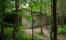
Between 1941 and 1944, the headquarters of the Army High Command was located southwest of the Mauerwald forester's lodge, not far from the Wolfsschanze leader's headquarters, not far from Rastenburg (Kętrzyn in Polish).
Religions
Before 1945, the Mauerwald forestry was part of the Evangelical Church of Engelstein in the church province of East Prussia of the Church of the Old Prussian Union and of the Catholic Church of the Good Shepherd in Angerburg in the Diocese of Warmia .
The current Mamerki is part of the Evangelical Church in Węgorzewo , a branch church of Giżycko (Lötzen) in the Masuria diocese of the Evangelical-Augsburg Church in Poland and the Catholic parish of Węgielsztyn in the Diocese of Ełk (Lyck) of the Roman Catholic Church in Poland .
traffic
Mamerki can be reached from the DW 650 voivodship road in a southerly direction via a side road that leads via Przystań (Pristanien , 1938 to 1945 Passdorf) to Kamionek Wielki (Steinort brickworks) and on to Radzieje (rose garden) .
The next train station is Przystań on the - although no longer regularly operated - railway line Kętrzyn – Węgorzewo (Rastenburg – Angerburg) .


