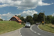
Probark
| Probark | ||
|---|---|---|

|
|
|
| Basic data | ||
| State : | Poland | |
| Voivodeship : | Warmia-Masuria | |
| Powiat : | Mrągowo | |
| Gmina : | Mrągowo | |
| Geographic location : | 53 ° 50 ' N , 21 ° 22' E | |
| Residents : | 185 (2011) | |
| Postal code : | 11-700 | |
| Telephone code : | (+48) 89 | |
| License plate : | NMR | |
| Economy and Transport | ||
| Street : | DK 16 : Grudziądz - Olsztyn - Mrągowo ↔ Mikołajki - Ełk - Augustów - Ogrodniki (- Lithuania ) | |
| Wola Muntowska - Piotrówka → Probark | ||
| Jakubowo - Nowy Probark → Probark | ||
| Rail route : | no rail connection | |
| Next international airport : | Danzig | |
Probark [ ˈprɔbark ] ( German Neu Proberg ) is a village in the Polish Warmian-Masurian Voivodeship . It belongs to the Gmina Mrągowo ( rural community Sensburg ) in the powiat Mrągowski ( Sensburg district ).
Geographical location
Probark is located on the north bank of the Probergsee ( Polish Jezioro Probarskie ) in the southern center of the Warmian-Masurian Voivodeship, six kilometers southeast of the district town of Mrągowo ( German Sensburg ).
history
The small village of Neu Proberg was until 1945 a residential area of the community (Alt) Proberg in the Sensburg district in the Gumbinnen district (from 1905: Allenstein district ) in the Prussian province of East Prussia . In 1867 there were 185 inhabitants, in 1885 151 and in 1905 only 75 inhabitants.
With the whole of southern East Prussia , Neu Proberg was transferred to Poland in 1945 as a result of the war and was given the Polish form of the name “Probark”. Today the village is the seat of a Schulzenamt ( Polish Sołectwo ) and thus a village in the Gmina Mrągowo (rural municipality Sensburg ) in the Powiat Mrągowski ( Sensburg district ), until 1998 the Olsztyn Voivodeship , since then part of the Warmia-Masurian Voivodeship. In 2011 Probark had 185 inhabitants.
religion
Protestant church
Until 1945 Neu Proberg was parish in the Protestant parish of Sensburg-Land in the church province of East Prussia of the Church of the Old Prussian Union . The relationship with the church in Mrągowo, now known as St. Trinity Church , still exists today, and is now part of the Masurian diocese of the Evangelical Augsburg Church in Poland .
Catholic Church
The St. Adalbert Church in Sensburg was the Catholic parish church for Neu Proberg before 1945. It belonged to the then diocese of Warmia . Today Probark is integrated into the parish Kosewo (Kossewen , 1938 to 1946 Rechenberg) with the branch parish in Jakubowo (Jakobsdorf) , now assigned to the newly formed Archdiocese of Warmia in the Polish Catholic Church .
traffic
Probark is located on the east-west axis of the Polish national road 16 (formerly German Reichsstraße 127 ), which connects three voivodships and leads to Lithuania . Probark is also connected to the neighboring towns to the north and south via side roads.
Although the Sensburg – Arys – Lyck railway runs through the town of Probark (Neu Proberg) , the neighboring town of Kosewo (Kossewen , 1938 to 1945 Rechenberg) was the nearest train station before 1945 . This railway line is no longer used today.
Web links
Individual evidence
- ↑ Polish Postal Code Directory 2013, p. 1032
- ↑ Due to the similarity of Polish-German names, the locations of the villages Probark and Nowy Probark are often confused. Old map material and new Polish directories indicate that Probark and New Proberg or Nowy Probark and (Old) Proberg are identical
- ^ Dietrich Lange, Geographical Directory of Places East Prussia (2005): Neu Proberg
- ↑ a b c New Proberg
- ↑ Wieś Probark w liczbach


