
Hermagor-Pressegger See
|
Borough Hermagor-Pressegger See
|
||
|---|---|---|
| coat of arms | Austria map | |
 |
|
|
| Basic data | ||
| Country: | Austria | |
| State : | Carinthia | |
| Political District : | Hermagor | |
| License plate : | HE | |
| Main town : | Hermagor | |
| Surface: | 205.36 km² | |
| Coordinates : | 46 ° 38 ' N , 13 ° 22' E | |
| Height : | 602 m above sea level A. | |
| Residents : | 6,886 (January 1, 2020) | |
| Postal code : | 9620 | |
| Area code : | 04282 | |
| Community code : | 2 03 05 | |
| NUTS region | AT212 | |
| Address of the municipal administration: |
Wulfeniaplatz 1 9620 Hermagor-Pressegger See |
|
| Website: | ||
| politics | ||
| Mayor : | Siegfried Ronacher ( SPÖ ) | |
|
Municipal Council : ( 2015 ) (27 members) |
||
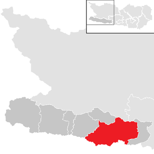
| Location of Hermagor-Pressegger See in the Hermagor district | ||
  |
||
 This picture shows the central part of Hermagor from above |
||
| Source: Municipal data from Statistics Austria | ||


Hermagor-Pressegger See ( Slov .: Šmohor-Preseško jezero ) is a municipality with 6886 inhabitants (as of January 1, 2020) in the Hermagor district in Carinthia , Austria . The city was named after the early Christian saint Hermagoras, who, according to legend, was the first bishop of the Patriarchate of Aquileia .
geography
Geographical location
The community is located in the lower Gailtal at the confluence of the Gitschtal in the Gailtal near the border with Italy . The municipality is bordered by the Carnic Alps in the south and the Gailtal Alps in the north . With the Pressegger See , the ninth largest lake in Carinthia is located in the municipality.
Community structure
The community is divided into the following cadastral communities :
- Egg ( Brdo )
- Görtschach ( Goriče )
- Guggenberg
- Hermagor ( Šmohor , formerly also Trg )
- Khunburg
- Mitschig ( Mičiče or Semičiče )
- Möderndorf ( Modrinja vas )
- Möschach ( Mošče )
- Nampolach ( Napole )
- Rattendorf ( Radnja vas )
- Tröpolach ( Drobolje or Dobropolje )
- Vellach ( Bela )
and these in turn in the following 64 localities (population in brackets as of January 1, 2020):
- Achleiten (3)
- Aigen (5)
- Bergl (25)
- Braunitzen ( Brnice ) (7)
- Brugg ( Moste ) (20)
- Burgstall (7)
- Danz (21)
- Dellach ( Dole ) (85)
- Egg ( Brdo ) (141)
- Eggforst (11)
- Förolach ( Borlje ) (177)
- Fritzendorf ( Limarce ) (63)
- Görtschach ( Goriče ) (165)
- Goetting ( Gocina ) (13)
- Grafenau ( Kozloz ) (0)
- Grunburg (73)
- Guggenberg (24)
- Hermagor ( Šmohor ) (1559)
- Jenig (175)
- Kameritsch ( Kamerče ) (64)
- Khunburg (206)
- Kleinbergl (29)
- Kraschach ( Krošane ) (55)
- Crazy (20)
- Kreuth ob Mellweg ( Rute pri Melvičah ) (53)
- Kreuth ob Möschach ( Rute pri Moščah ) (15)
- Kreuth ob Rattendorf (77)
- Kühweg ( Skubiče ) (182)
- Kühwegboden (187)
- Latschach ( Loče ) (77)
- Liesch (2)
- Mellach ( Mele ) (33)
- Mellweg ( Melvice ) (48)
- Micheldorf ( Velika vas ) (158)
- Mitschig (Mičiče) (79)
- Möderndorf ( Modrinja vas ) (156)
- Nampolach ( Napole ) (20)
- Neudorf ( Novo vas ) (297)
- Neuprießenegg (25)
- Obermöschach (31)
- Obervellach (213)
- Passriach ( Pazrije ) (128)
- Podlanig (37)
- Postran (115)
- Potschach ( Potoče ) (45)
- Press harrows ( Preseka ) (229)
- Presseggersee ( Preseško Jezero ) (122)
- Radnig (214)
- Radnigforst (8)
- Rattendorf ( Radnja vas ) (305)
- Schinzengraben (28)
- Schlanitzen ( Zelenica ) (42)
- Schmidt (1)
- Siebenbrünn ( Zavrh ) (4)
- Sonnenalpe Nassfeld (46)
- Sonnleitn (19)
- Süßenberg ( Planja ) (19)
- Toschehof ( Tešinje ) (0)
- Tröpolach ( Dropolje ) (446)
- Untermöschach ( Spodnje Mošče ) (47)
- Untervellach ( Spodnja Bela ) (260)
- Wadded ( Vačice ) (123)
- Wittenig ( Vitenče ) (47)
- Breeding (0)
Another location is the Rotte Thurnhof .
Neighboring communities
| Gitschtal | Weissensee , Paternion | |
| Kirchbach |
.svg)
|
Sankt Stefan im Gailtal |
| Moggio Udinese , Paularo | Pontebba | Malborghetto-Valbruna |
history
Finds show that today's municipal area was already settled in pre-Roman times. The oldest known finds in the area around Hermagor belong to the so-called Urnfield Period (1200 to 1800 BC) and are partly depot and litter finds. This includes a deposit from Dellach, formerly the municipality of Egg, which was recovered in 1889 under a stone slab. It contained two large, medium-sized rag axes, one with faceted lobes and two bronze rings. A handlebar dagger, typical of the older Urnfield period, was found in 1937 at an altitude of around 1400 m on the Jadersdorfer Ochsenalm, Gitschtal. He points to the influences from the southwest and northern Italy. Iron ore was mined here and exported to the Mediterranean. Around 15 BC The Celtic Kingdom of Noricum and thus also today's municipality was occupied by the Roman Empire and incorporated into the empire. Around this time, the Hadn Wall was also located, a dam that ran through the valley near Rattendorf and was supposed to protect Gurina .
The parish Hermagor was first mentioned in a document in 1169, its titular saint Hermagoras refers to a foundation by Aquileja . Conveniently located at the crossroads from Gitschtal to Kreuzbergsattel , the place was created as a planned market, was granted market rights in 1288 and developed into the capital of the Gailtal . In the 15th century the Turks invaded and devastated the villages in the entire Gail Valley. From the 16th century, the Hermagor market belonged to the rulership rights of the County of Ortenburg .
In 1779 Franz Xaver Freiherr von Wulfen discovered the Wulfenia flower named after him on the Gartnerkofel .
In 1868 the place became the seat of the district administration and thus the center of the district of the same name . During the k. u. k. Monarchy was Hermagor garrison of the 1st and 2nd battalions of the k. k. Landwehr Infantry Regiment No. 4.
In 1880 the then market town of Hermagor had 709 inhabitants. All of them belonged to the German language group. At that time, the place was located immediately northwest of the language border. The villages from Potschach and Fritzendorf, which today belong to Hermagor, were Slovene-speaking. While the Slovenian ethnic group was almost entirely Catholic, Hermagor also had a Protestant minority. This was to be found in almost all German-speaking villages in the area and in 1880 made the majority in the villages of Achleiten, Aigen, Danz, Jenig, Kameritsch, Kreuth ob Rattendorf, Liesch, Radnig, Radnigforst, Rattendorf and Watschig, which are now part of the municipality.
Effective October 10, 1930, the Hermagor market was elevated to a town by resolution of the Carinthian regional government. The occasion and background of this town elevation were the events surrounding the Carinthian defensive struggle (1918–1920) and the Carinthian referendum of October 10, 1920 .
In April 1938, Hermagor was declared a so-called “Führergemeinde”, as there was not a single “no” vote in the entire community against the annexation of Austria to the National Socialist German Reich . In the course of Aryanization , the general store of the Jewish trader Arthur Glesinger was forced to close. The Hermagor-based doctor Albert Menninger-Lerchenthal was transferred to Magdeburg in January 1943 due to his Jewish roots and died during a home leave in the summer of 1944 under unexplained circumstances on the Radniger Alm near the city.
More than 3000 young women were in the so-called "Maidenlager" of the Reich Labor Service in the upper part of Hermagor during the war years . The female workers, mainly from Styria and northern Germany, support the agricultural businesses in the community.
In April 1942, several Carinthian-Slovenian families were forcibly resettled or deported from the Hermagor community. The main local responsibility for this was borne by the National Socialist district leader of Hermagor Julian Kollnitz , who was sentenced to ten years imprisonment in the course of denazification in 1949.
The city of Hermagor was also the location of the "Haßlacher" company, which manufactured wooden barracks for the Wehrmacht and Air Force. Some British and Soviet prisoners of war, the latter under particularly adverse circumstances, also had to work here. Starting in October 1944, this led to several Allied bombing raids on the southeastern part of Hermagoras, in which the aforementioned arms factory and the train station were located. On May 8, 1945, British units advancing from the Plöckenpass reached the town of Hermagor. The association “Erinnern Gailtal” counts more than 200 victims of National Socialism in the Hermagor district and in the rest of the Carinthian Gailtal , but the number of unreported cases is estimated to be significantly higher.
In 1958 Möschach was attached and in 1973 the large community of Hermagor-Pressegger See was created through the incorporation of Egg, Mitschig, Görtschach and parts of Rattendorf.
population
Population development

Ethnic groups, religion
At the time of the 2001 census, Hermagor-Pressegger See had 7,232 inhabitants (1991: 7,403), mostly members of the German or Slovene-speaking ethnic group. 94.7% of them had Austrian, 1.6% German, 1.1% Bosnian and 1.0% Croatian citizenship.
68.8% of the population confessed to the Roman Catholic , 25.6% to the Protestant Church and 1.5% were of Islamic faith, 2.4% without religious belief.
Culture and sights


- Möderndorf Castle with Gailtaler Heimatmuseum
- Lerchenhof Palace in Untermöschach was built between 1848 and 1851 as the seat of Baron Julius von Wodley. The building, which has been a listed building since 1939 and is now used as a hotel-inn, is a prime example of late classicist - Biedermeier architecture in Carinthia.
- The Malenthein castle ruins are located on the south-eastern slope of the Guggenberg near Kühweg. The oldest documented mention of a tower owned by Bamberg comes from the year 1311, a further expansion is documented for 1317. Until 1395 the castle was the seat of a regional court. At the end of the 15th century it went to Friedrich III. about, whose successor Maximilian I awarded it in 1506 to Johann Geumann von Galsbach, Grand Master of the Order of St. George in Millstatt. He handed it over to his brother-in-law Georg von Malenthein, and the castle has been named after him ever since. The tower was still inhabited in 1688, but the castle gradually fell into disrepair from the 18th century. Parts of the outer wall ring and 6 to 8 meter high remains of the residential tower are still visible today.
- Castle ruins Feste Khünburg . Within sight of Hermagor in an easterly direction, there is a mighty tower, the keep of the old fortress Khünburg, on a relapse crest of the flank of the leech group sloping to the southeast. A narrow, ridge-like ridge, secured by a moat, leads to the castle. The building could not originally be very spacious, as the small plateau did not offer enough space for it. One suspects the existence of a chapel on the grassy forecourt on the south side of the tower. Fire, difficulties with the water supply, this had to be brought through long pipes. Ultimately, the impassable location of this castle led to its abandonment. The Khünburgers later relocated their headquarters to the more comfortable, easily accessible valley castle "castrum Kynegg" (today's Egg). In addition to possessions in South Tyrol and Overseas, the Counts of Kuenburg still have their preferred family residence in Egg near Hermagor.
- Filialkirche Schlanitzen. The branch church “St. Leonhard ”, a medium-sized, late Gothic building, stands south of Tröpolach, on a 116 m higher, abruptly falling wooded hilltop (Pleik). Paolo Santonino reported on the consecration of this “new” church on October 23, 1485 by the Bishop of Caorle. Tradition also knows of a wooden precursor chapel that was built by miners. The church consists of a wide, spacious, almost square nave, the flat ceiling of which is supported by a joist with stenciled paintings. The ceiling is divided into numerous longitudinally rectangular fields by narrow longitudinal and wider transverse strips and painted over and over, mostly with stencils, but also freehand. You can see an almost unmistakable abundance of different knot, wickerwork, star, swirl wheel patterns and rosettes. Also of interest is the right winged altar, the tied, larger-than-life Christ with pond fangs and scourge, as well as the remarkable group of crosses with Christ and the two thieves. Until around 1890 there was still a chain that was stretched around the church twice. It fell victim to the rust, remnants of it were later processed into sheet metal and thus the entrance door of the Tröpolach parish church was shod. Outside - on the north wall - you can see a late Gothic, larger than life fresco of St. Christopher. The young giant carries the blessing baby Jesus on his right shoulder. This fresco could be seen from far away from the valley when the forest was not yet covering the church. The travelers looked up to him and asked the saint for his intercession. According to popular belief, this secured her life for that one day.
- Parish church Rattendorf
- Parish church Hermagor
- Watschiger tolerance prayer house
Economy and Infrastructure
In recent years the community has developed into an important two-season tourist community (over one million overnight stays annually). In winter, the Nassfeld ( Mokrine ) ski arena, one of the largest ski areas in the southern Alps, attracts many tourists, while in the summer months there is an extensive range of holiday options with water (Lake Pressegger See, Gail), hiking, cycling, mountaineering, geotrail, fishing and culinary festivals and various children's attractions.
Of the 3228 employees in 2001, 600 were employed in the hotel and restaurant sector, followed by 471 employees in trade, repair of motor vehicles and consumer goods, and 441 employees in the production of goods.
Agriculture and Forestry
In 1999 only 86 full-time agricultural and 455 part-time farms were counted in the municipality of Hermagor-Pressegger See. In terms of proportion, the municipality is below the Carinthian national average. The large landowners are legal entities (agricultural communities) who make up a little less than half of the cultivated area. Arable farming is not very important, in 2009 789 hectares were designated as arable land, more than half of which, however, are arable meadows and pastures. Spring barley, oats and grain maize are primarily grown on 134 hectares of pure arable land.
Of the 599 holdings existing in 2009, forestry was the main activity of 320 (53.4% of holdings), followed by cattle farming (177) and sheep breeding (47). The livestock population has halved in the last 50 years.
Forests and wood play an important role as an important economic pillar for the rural existence. The management of the forest areas, which are consistently owned by farmers, is growing in importance. However, with a few exceptions, it was not possible to implement industrial refinement of the wood on site. Wood is also gaining in importance in the context of environmental protection. The town of Hermagor and the tourist town of Tröpolach, for example, are supplied with district heating using biomass.
Alpine farming is also of central importance. Cattle and horses spend the summer on the alpine pastures. The milk is processed there into Gailtaler Almkäse and other regional specialties. These alpine farms are the destination of thousands of alpine hikers and mountain hikers every year, who like to stop by and appreciate the Gailtal hospitality and cosiness, but also the enchantingly beautiful mountains of the Carnic and Gailtal Alps.
Trade and commerce
Even if Austria's smallest district capital, Hermagor is still the economic center of the Gail, Gitsch and Lesach valleys. Here at the intersection of two valleys, craft and trade settled early on. Hermagor has changed from a more agricultural economy at the time to a strong tourist region in recent decades. Numerous jobs have been created through tourism, and trade and industry benefit from it. The service industry in all its facets has grown enormously. But the craft still has its importance.
As of May 1, 2012, 514 companies of various sizes and from a wide variety of industries were registered in the town of Hermagor-Pressegger See.
tourism
Modern tourism emerged around 1800 with the civic educational trip. Hermagor and the Gailtal could not yet score, the interest in this valley was limited. It was not until the last third of the 19th century that the Gail valley began to be developed for tourism. In 1882 the "Hermagor Tourist Association" was founded. The decisive impetus came in 1894 with the construction of the Gailtalbahn, which was extended to Kötschach-Mauthen in 1915 for purposes of the war. In Hermagor there were at least five inns with guest rooms. The "economic miracle" after the Second World War helped tourism achieve unimagined growth rates. Federal President Adolf Schärf spent numerous holidays on Lake Pressegger See. The Viennese in particular were drawn to the Pressegger See. The lake received modern bathing establishments. Until then, winter tourism played a subordinate role.
That changed in 1962. Arnold Pucher, later called the “Nassfeld Kaiser”, built the first hotel with the “Wulfenia”. At the same time, Hans Jenul built the first drag lift. Today Nassfeld is the largest ski area in Carinthia. The ski area offers over 30 cable cars and lifts and over 100 kilometers of slopes, the longest single-cable gondola lift in Europe and the longest valley run. The connection to the valley, the construction of new hotels and the creation of modern infrastructures caused the number of overnight stays and the number of day visitors to skyrocket.
490 tourism businesses in Hermagor-Pressegger See have a total of 10,576 beds on the mountain and in the valley (as of May 1, 2012). With over one million overnight stays, the Hermagor-Pressegger See tourist community is now one of the most important tourist centers in Carinthia and southern Austria. In winter, Hermagor is at the top in Carinthia. Overall, Hermagor is among the 20 most overnight communities in Austria.
Summer tourism
The Hermagor area, especially the Presseggersee, was very popular with well-off bourgeois families from the centers of the then monarchy even before the First World War . The constant weather, the pleasant temperatures of Lake Presseggersee and the exceptionally beautiful natural landscape around the lake with Austria's second largest reed area (after Lake Neusiedl) were reasons for the popularity of this region. The first pensions and hotels were built around the lake, traffic routes were built and a modest infrastructure was created. Today, the guest is offered a modern infrastructure, beautiful bathing beaches, very good gastronomy, bike paths, hiking trails, Carinthia's first adventure park and accommodation ranging from private accommodation to five-star hotels.
In summer, Nassfeld is a popular excursion and vacation destination, also for geologists, due to the unique mountain and rock structure. The region is also very popular with botanists. Among the series of rare plants and flowers, the Wulfenia stands out in particular . The mint is only found around the Gartnerkofel (altitude approx. 1700 m ) and in the Prokletije Mountains in the border area between Montenegro, Kosovo and Albania.
Waters

The Pressegger See has the character of a lowland lake with a shallow basin in the middle of an extensive reed population. This covers the adjacent bogs to an extent of about 300 hectares and forms the second largest reed landscape in Austria after Lake Neusiedl. The formation of the Pressegger See dates back to the conditions after the end of the Ice Age. During the Ice Age, a glacier flowed into the valley between the Spitzegel-Zug in the north and the Phyllite ridge of the Eggforstes in the south. Before the last icing, the Gitschtal was drained via today's lake area towards Görtschach and the Gail. Since the Gail bed rose more and more due to the gravel, the lower section of the valley lost its previous drainage. The water from the precipitation collected in the catchment area of the lower Gitschtal to form a lake, the last remainder of which is today's Pressegger See.
The length of the lake in the EW direction is about 900 meters, the width about 600 meters. The lake area covers around 55 hectares. This makes it ninth among Carinthia's lakes. The greatest depth in the area of a spring funnel is almost 14 meters. Only one seventh of the lake bed is deeper than six meters below the water level, the average water depth is no greater than three and a half meters. The water volume is estimated at two million cubic meters.
The Pressegger See is fed on the one hand by the Vella Bach and on the other hand by numerous underground, densely branched springs. A legend tells that a calf in Lake Constance, lying halfway up on the way to Nassfeld, went down and drowned. The farmer was looking for it, but soon gave up looking for it. A few weeks later it was floating on the surface of the Pressegger See. It had reached the lake, about 15 kilometers away, through ravines and underground water courses.
politics
City Councilor and Mayor
The city council (city government) consists of seven members. The directly elected mayor is Siegfried Ronacher (SPÖ).
Municipal council
The municipal council of Hermagor has 27 members and has been composed as follows since the municipal council election in 2015 :
coat of arms
On June 18, 1619, Hermagor was awarded a parchment vial of a coat of arms certificate, of which only copies from 1642 without images have survived. As a result, Hermagor carried a seal that shows the half-length of Hermagoras . Between 1734 and 1796 a seal with a full-length representation of the saint was used, and subsequently some details of the Hermagoras depiction vary. When the coat of arms was confirmed in 1974, one returned to the oldest surviving seal, which also corresponds to the blazon from 1619.
On the occasion of the confirmation of the coat of arms, the following heraldic description was established:
- "In red the half-length figure of Bishop Hermagoras in a violet cloak, in the right a green palm branch, in the left holding a golden bishop's staff."
The flag is red and yellow with an incorporated coat of arms.
Parish partnership
Since 1998 there has been a town partnership with the neighboring municipality of Pontebba in the Italian Canal Valley .
sons and daughters of the town
- Armin Assinger (* 1964), Austrian ski racer , now a television presenter
- Roland Assinger (* 1973), ski racer
- Anton Dekan (* 1948), pseudonym Tony Dee, writer and musician
- Max Domenig (1886–1952), sculptor
- Karlheinz Essl senior (* 1939), trade manager and art collector
- Robert Essl (1980 / 81–2019), photographer
- Franc Grafenauer (1860–1935), member of the Reichsrat of the Carinthian Slovenes and organ builder
- Gerhard Lampersberg (1928–2002), composer
- Matthias Mayer / Matija Majar-Ziljski (1809–1892), clergyman and national Slovenian activist
- Oswin Moro (1895–1941), teacher and folklorist
- Gotbert Moro (1902–1987), historian, director of the Carinthian State Museum and State Archives
- Engelbert Obernosterer (* 1936), writer
- Paul Pellar (1919–1988), Lutheran theologian, superintendent of Carinthia and East Tyrol
- Leo Pietsch (1905–1981), auxiliary bishop
- Arnold Pucher (* 1940), Nassfeld pioneer and honorary citizen
- Markus Salcher (* 1991), disabled sports
- Hans Schabus (* 1970), artist
- Robert Schabus (* 1971), filmmaker
- Rudolf Tillian (1913–2013), politician, former mayor, president of the Carinthian state parliament; Bearer of the Great Golden Medal of Honor of the State of Carinthia, bearer of the Great Golden Medal of Honor with the star for services to the Republic of Austria, honorary citizen and holder of the ring of honor of the municipality of Hermagor, honorary president of the Carinthian Association of Municipalities and honorary member of the Austrian Association of Municipalities
- Ines Widmann (1904–2002), writer
literature
- Gailtaler Zeit Sprung - A Valley through the Ages, Volume 1, 2019.
- Bernhard Gitschtaler (Ed.): Erased names. The victims of National Socialism in and out of the Gailtal - A memory book . Otto-Müller Verlag, Salzburg 2015.
- Bernhard Gitschtaler, Daniel Jamritsch: The Gailtal under the swastika. About elements of National Socialist rule in the Gailtal . kitab-Verlag, Klagenfurt / Celovec 2013.
- Gotbert Moro: Hermagor. History, nature, present . History Association for Carinthia, 1969.
- Hubert Pietschnigg: Hermagor . 1st edition 1931 2nd edition 1988.
- Heidi Rogy: Municipality of Hermagor-Pressegger See. History - culture - nature . Publishing house of the history association for Carinthia, Klagenfurt 2010.
Web links
- City of Hermagor-Pressegger See
- 20305 - Hermagor-Pressegger See. Community data, Statistics Austria .
Individual evidence
- ↑ Statistics Austria: Population on January 1st, 2020 by locality (area status on January 1st, 2020) , ( CSV )
- ↑ Gernot Piccotini: Primeval, Roman and early medieval finds in the Hermagor district.
- ↑ Marienpilgerweg. In: marienpilgerweg.at. Retrieved October 19, 2016 .
- ↑ Jenig. In: jenig.at. Retrieved October 19, 2016 .
- ↑ KK Statistische Central-Commission, Special-Orts-Repertorien of the kingdoms and countries represented in the Oesterreichischen Reichsrathe. Volume V Carinthia (Vienna 1883) p. 2.
- ↑ KK Statistische Central-Commission, Special-Orts-Repertorien of the kingdoms and countries represented in the Oesterreichischen Reichsrathe. Volume V Carinthia (Vienna 1883) pp. 2-4.
- ↑ Bernhard Gitschtaler, Daniel Jamritsch: The Gail Valley in the Third Reich . Kitab, Klagenfurt 2013, ISBN 978-3-902878-36-6 .
- ^ Bernhard Gitschtaler: Jakob, Franz and Josef Haßlacher - Three brothers between Dollfuss, Hitler and denazification. In: Remember Gailtal. Retrieved May 13, 2020 .
- ↑ New book: Nazi Victims in the Gail Valley. In: ORF Carinthia. October 16, 2015, accessed May 13, 2020 .
- ^ Statistics Austria, population census, demographic data. May 15, 2001, accessed March 3, 2019 .
- ↑ Dehio Kärnten , Vienna 2001, p. 436
- ^ Hermann Wiesner: Hermagor: Geschichte, Natur, Gegenwart , pp. 91–126, Kärntner Druck- und Verlagsgesellschaft 1969.
- ↑ Karl Ginhart: Hermagor: History, Nature, Present.
- ↑ Hermagor Tourist Information.
- ↑ Heidi Rogy: The development of tourism in the area of Hermagor. From history - culture - nature pp. 145 ff., Published by the municipality of Hermagor Pressegger See.
- ^ Quoted from Wilhelm Deuer: The Carinthian municipal coat of arms . Verlag des Kärntner Landesarchiv, Klagenfurt 2006, ISBN 3-900531-64-1 , p. 136.