
Șoimuș (Hunedoara)
|
Şoimuş Falkendorf Marossolymos |
|||||
|
|||||
| Basic data | |||||
|---|---|---|---|---|---|
| State : |
|
||||
| Historical region : | Transylvania | ||||
| Circle : | Hunedoara | ||||
| Coordinates : | 45 ° 55 ' N , 22 ° 53' E | ||||
| Time zone : | EET ( UTC +2) | ||||
| Height : | 194 m | ||||
| Area : | 68.59 km² | ||||
| Residents : | 3,371 (October 20, 2011) | ||||
| Population density : | 49 inhabitants per km² | ||||
| Postal code : | 337450 | ||||
| Telephone code : | (+40) 02 54 | ||||
| License plate : | HD | ||||
| Structure and administration (as of 2016) | |||||
| Community type : | local community | ||||
| Structure : | Șoimuș, Bălata , Bejan , Bejan-Târnăvița , Boholt , Căinelu de Jos , Chișcădaga , Fornădia , Păuliș , Sulighete | ||||
| Mayor : | Mihai Gabriel Irimie ( PNL ) | ||||
| Postal address : | Str. Principală, no. 310 loc. Șoimuș, jud. Hunedoara, RO-337450 |
||||
| Website : | |||||


Șoimuș (outdated Șoimușul Mureșan ; German Falkendorf , Hungarian Marossolymos or Maros-Solymos ) is a municipality in the Hunedoara district in Transylvania , Romania .
The place is also known under the Hungarian names Solymos and the German Scholmosch .
Geographical location

The municipality Șoimuș is located south of the Transylvanian Ore Mountains ( Munții Metaliferi ) southwest of the Transylvanian Basin ( Podișul Transilvaniei ). At the mouth of the Boholt - a right tributary of the Mureș ( Mieresch ) - and the national road ( drum național ) DN 76, the place is about five kilometers from the district capital Deva ( Diemrich ). The nine incorporated villages are on the approx. 6,800 hectares of the community between 3 and 13 kilometers from the community center. About 63% of the community area is cultivated.
The Romanian A1 motorway should (when finished) also run on the site of the village.
history
Șoimuș a former Roman settlement, was first mentioned in 1278. In 1459 the place became a market town in the historical Hunyad County ( Eisenmarkt County ). Until 1839, Șoimuș was a raft port and a customs station for the salt rafting on the Mieresch . According to reports by G. Téglás , B. Pósta , H. Schroller , u. a. back to the Early Bronze Age . Archaeological finds were made in Șoimuş near La Telegi ; in the incorporated village of Boholt ( Bolden ) on Mount Ciuta .
The Deva – Brad railway , which was built after 1940 and which was finally closed in 1996 due to the landslides in the region and sold as old iron, ran on the area of the municipality, near the incorporated villages of Chişcădaga and Păuliş .
population
The population of the municipality developed as follows:
| census | Ethnic composition | |||||||
|---|---|---|---|---|---|---|---|---|
| year | population | Romanians | Hungary | German | other | |||
| 1850 | 3910 | 3715 | 73 | 18th | 104 | |||
| 1900 | 4962 | 4778 | 113 | 44 | 27 | |||
| 1941 | 4952 | 4896 | 27 | 8th | 21st | |||
| 2002 | 3549 | 3462 | 68 | 4th | 15th | |||
Since the official census of 1850, mostly Romanians have been registered in the area of today's municipality . The highest population (5219) - at the same time that of the Romanians (4945) and the Magyars (184) - was determined in 1910. The highest population of the Roma (100) was registered in 1850 and that of the Romanian Germans was registered in 1900. In addition, one each of the Slovaks was registered in 1890 and 2002, two Slovaks in 1930, one Serb each in 1900, 1930, 1977 and 1992 , and one Ukrainian each in 1966, 1977 and 2002 . The 2011 census counted 3371 people in 1489 households in the municipality.
Attractions
- The wooden churches Sf. Nicolae in Șoimuș, built in 1705, extended in the 19th century, and the Adormirea Maicii Domnului in Sulighete , built in the 18th century and renovated in the 19th century, are listed as historical monuments.
- On the area of the incorporated village of Boholt, the nature reserve of the same name once extended to about one hectare because of its three mineral water springs. One of the springs gives about 10,000 liters per day and has been bottled since 1883. Currently the reserve is limited to the gorges of the Teiului Valley , surrounded by plants on limestone.
photos
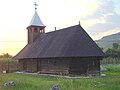
Wooden church in Șoimuș

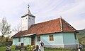
Church in Șoimuș
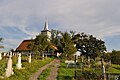
Wooden church in Sulighete
Wooden church in Căinelu de Jos


Web links
Individual evidence
- ↑ 2011 census in Romania at citypopulation.de
- ^ Dictionary of the localities in Transylvania
- ↑ a b Heinz Heltmann, Gustav Servatius (Ed.): Travel Guide Siebenbürgen. Kraft, Würzburg 1993, ISBN 3-8083-2019-2 .
- ^ Institute Of Archeology - Șoimuș, accessed on March 21, 2013 (Romanian)
- ^ Institute Of Archeology - Boholt, accessed March 22, 2013 (Romanian)
- ↑ Census, last updated November 2, 2008, p. 147 (Hungarian; PDF; 1.1 MB)
- ↑ Information on the church in Șoimuș from biserici.org accessed on March 22, 2013 (Romanian)
- ↑ Information on the church in Sulighete from biserici.org accessed on March 22, 2013 (Romanian)
- ↑ List of historical monuments of the Romanian Ministry of Culture, updated 2010 (PDF; 7.10 MB)
- ↑ World Database on Protected Areas - Rezervatia Boholt nature reserve (English)
Băcia | Baia de Criș | Băița | Balșa | Bănița | Baru | Bătrâna | Beriu | Blăjeni | Boșorod | Brănișca | Bretea Română | Buceș | Bucureșci | Bulzeștii de Sus | Bunila | Burjuc | Cârjiți | Cerbăl | Certeju de Sus | Crișcior | Densuș | Dobra | General Berthelot | Ghelari | Gurasada | Hărău | Ilia | Lăpugiu de Jos | Read | Lunca Cernii de Jos | Luncoiu de Jos | Mărtineşti | Orăştioara de Sus | Pestișu Mic | Pui | Răchitova | Rapoltu Mare | Râu de Mori | Ribița | Romos | Sălașu de Sus | Sântămăria-Orlea | Sarmizegetusa | Șoimuș | Teliucu Inferior | Tomeşti | Toplița | Totești | Turdaș | Vălișoara | Vața de Jos | Vețel | Vorța | Zam