
Argein
|
Argein Argenh |
||
|---|---|---|
|
||
| region | Occitania | |
| Department | Ariège | |
| Arrondissement | Saint-Girons | |
| Canton | Couserans Ouest | |
| Community association | Couserans-Pyrénées | |
| Coordinates | 42 ° 56 ′ N , 1 ° 0 ′ E | |
| height | 517-1,675 m | |
| surface | 11.09 km 2 | |
| Residents | 194 (January 1, 2017) | |
| Population density | 17 inhabitants / km 2 | |
| Post Code | 09800 | |
| INSEE code | 09014 | |

Argein ( Occitan : Argenh ) is a French commune with 194 inhabitants (as of January 1, 2017) in the Ariège department in the Occitania region ; it belongs to the arrondissement of Saint-Girons , to the association of municipalities Couserans-Pyrénées and to the canton of Couserans Ouest (until 2015: canton of Castillon-en-Couserans ). The inhabitants are called Argenois / Argenoises .
geography
Argein is located around 83 kilometers south-southwest of the city of Toulouse in the west of the Ariège department. The community consists of the village of Argein, the hamlet of Viellot , scattered settlements and individual farmsteads. The Bouigane crosses the municipality eastwards. Argein lies within the Pyrénées Ariégeoises Regional Nature Park . Large parts of the community are mountainous and forested. The highest point in the municipality is the Pic de Moussaou . In terms of traffic, the community is located on the D618 far away from any major national traffic connections.
Argein is surrounded by the neighboring communities of Balaguères in the north, Arrout in the northeast, Audressein and Sor in the east, Salsein in the southeast, Bonac-Irazein in the southwest and Aucazein and Villeneuve in the west.
history
At the time of the Kingdom of France, Argein was the seat of a court and a barracks. The castle of the Montégut de Rozès family on the right bank of the Bouigane was burned down in the turmoil of the French Revolution. In the Middle Ages, the place was within the province of Couserans, which in turn was part of the province of Gascony. The parish was part of the Saint-Girons district from 1793 to 1801. In addition, Argein was within the canton of Castillon-en-Couserans from 1793 to 2015 . The parish has been assigned to the Arrondissement of Saint-Girons since 1801.
Population development
| year | 1793 | 1800 | 1846 | 1911 | 1921 | 1936 | 1946 | 1962 | 1968 | 1975 | 1982 | 1990 | 1999 | 2006 | 2014 |
| Residents | 632 | 385 | 881 | 515 | 380 | 342 | 271 | 235 | 214 | 211 | 193 | 164 | 149 | 155 | 196 |
| Sources: Cassini and INSEE | |||||||||||||||
Attractions
- Church Saint-Pierre in the 15th century
- Memorial to the Fallen
- three wayside crosses
- Lavoir (wash house)
- More Attractions

Mairie (Town Hall) of Argein
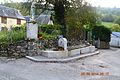
Fountain with a statue of a saint

Saint-Pierre village church
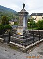
Memorial to the Fallen
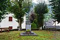
crossroads


Web links
- Information on cassini.ehess.fr
- Location of the place in France
- Argein on the side of the IGN
- Photos of the Saint-Pierre church
- Portrait and landmarks of the community