Gabre
| Gabre | ||
|---|---|---|
|
|
||
| region | Occitania | |
| Department | Ariège | |
| Arrondissement | Saint-Girons | |
| Canton | Arize-Lèze | |
| Community association | Arize Lèze | |
| Coordinates | 43 ° 5 ' N , 1 ° 25' E | |
| height | 286-570 m | |
| surface | 13.36 km 2 | |
| Residents | 123 (January 1, 2017) | |
| Population density | 9 inhabitants / km 2 | |
| Post Code | 09290 | |
| INSEE code | 09127 | |
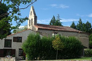
 Saint Laurent village church |
||
Gabre ( Occitan same name) is a French commune with 123 inhabitants (as of January 1, 2017) in the Ariège department in the Occitanie region (previously Midi-Pyrénées ); it belongs to the arrondissement of Saint-Girons and the canton of Arize-Lèze .
location
Gabre is in the north of the Ariège department. The closest city is Pamiers , about 17 kilometers (as the crow flies) to the east ; the city of Toulouse is just under 70 kilometers to the north. The municipality is located within the Pyrénées Ariégeoises Regional Nature Park .
The community consists of the village Gabre, some hamlets and individual farms.
history
The place has been settled since the early days. This is evidenced by the Goudère dolmen. In addition, the place name is derived from the Celtic word gabros . In the Middle Ages it was part of the County of Foix . The Order of Malta established a commandery in 1281 with the consent of the French king. Two years later a bastide was built. This was called the Bastide de Plaisance . Since that time Gabre has belonged to the Languedoc region and no longer to the County of Foix. In the wars of religion, the Huguenots destroyed the place in 1568. The previous village church became a reformed church until 1598. After that it was returned to the Catholics and the Protestants built their own church. The community belonged to the Mirepoix-Pamiers district from 1793 to 1801. In addition, it was from 1793 to 2015 part of the canton of Le Mas d'Azil (1793-1801 under the name of Canton Mas d'Azis ).
Population development
| year | 1793 | 1806 | 1821 | 1841 | 1846 | 1851 | 1881 | 1962 | 1968 | 1975 | 1982 | 1990 | 1999 | 2006 | 2012 |
| Residents | 567 | 650 | 611 | 676 | 651 | 593 | 562 | 131 | 106 | 96 | 99 | 95 | 92 | 92 | 104 |
| Sources: Cassini and INSEE | |||||||||||||||
In the 19th century the place had over 600 inhabitants. The increasing mechanization of agriculture led in the first half of the 20th century to a continuous decline in the number of inhabitants to the lows around 2000.
Attractions
- Dolmen of Goudère, a monument historique
- Saint-Laurent village church from 1725, a monument historique
- Reformed church from the 19th century
- the houses around the church square are on the spot where the Maltese Commandery used to be
- Rieutalhol mill (partly 16th century, partly from 1743)
- Reservoirs Lac de Filleit and Lac de Mondely
