
Lacourt (Ariège)
|
Lacourt La Cort |
||
|---|---|---|
|
||
| region | Occitania | |
| Department | Ariège | |
| Arrondissement | Saint-Girons | |
| Canton | Couserans Est | |
| Community association | Couserans-Pyrénées | |
| Coordinates | 42 ° 57 ′ N , 1 ° 11 ′ E | |
| height | 411-1,232 m | |
| surface | 16.50 km 2 | |
| Residents | 196 (January 1, 2017) | |
| Population density | 12 inhabitants / km 2 | |
| Post Code | 09200 | |
| INSEE code | 09149 | |
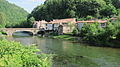
.jpg) Lacourt and the River Salat |
||

Lacourt ( Occitan : La Cort ) is a French commune with 196 inhabitants (as of January 1, 2017) in the Ariège department in the Occitanie region ; it belongs to the arrondissement of Saint-Girons , the association of municipalities Couserans-Pyrénées and the canton of Couserans Est (until 2015: canton of Saint-Girons ). The inhabitants are called Lacourtais / Lacourtaises .
geography
Lacourt is located around 77 kilometers south-southwest of the city of Toulouse in the west of the Ariège department. The municipality consists of the village of Lacourt, the hamlets of Chunaut , Espou , Milas and Sengouagneich , scattered settlements and individual farms. The Salat River flows through the municipality in a northerly direction. Lacourt lies within the Pyrénées Ariégeoises Regional Nature Park . Large parts of the community are mountainous and forested. The highest point is the Table des Quatre Seigneurs in the west of the municipality. In terms of traffic, the community is on the D3.
Lacourt is surrounded by the neighboring communities of Eycheil in the north-west and north, Encourtiech in the north, Rivèrenert in the north-east, Erp in the east, Soueix-Rogalle in the south-east and south, Alos in the south-west and west and Moulis in the west.
history
The castle Château de Chunaut , built by the Duke of Couserans, is mentioned in the 12th century . In the Middle Ages, the place was within the province of Couserans, which in turn was part of the province of Gascony. The parish was part of the Saint-Girons district from 1793 to 1801. In addition, Lacourt was within the canton of Saint-Girons from 1793 to 2015 . The parish has been assigned to the Arrondissement of Saint-Girons since 1801. Lacourt was created in its current form between 1790 and 1794, when Lacourt and Espou merged to form today's municipality.
Population development
| year | 1793 | 1800 | 1841 | 1911 | 1921 | 1926 | 1962 | 1968 | 1975 | 1982 | 1990 | 1999 | 2006 | 2014 | 2016 |
| Residents | 874 | 801 | 1,278 | 1,038 | 797 | 813 | 427 | 429 | 356 | 361 | 279 | 264 | 211 | 203 | 198 |
| Sources: Cassini and INSEE | |||||||||||||||
Attractions
- Church Saint-Pierre-aux-Liens
- Commemorative plaque for the fallen
- Cave Grotte de Charblac and numerous other caves
- 18th century bridge over the Salat
- numerous wayside crosses (including Croix de la Baraque, Croix de la Lauze and Croix de Sournis)
- Remains of the 12th century Château de Chunaut
- More Attractions
District Nabech with bridge and river

Entrance to Lacourt

Lacourt and its surroundings

Landscape near Lacourt

Remnants of the Château de Chunaut
.jpg)
.JPG)
.jpg)
.JPG)
.jpg)
Web links
- Information on cassini.ehess.fr
- Location of the place in France
- Lacourt on the IGN side
- Photos of the Saint-Pierre-aux-Liens church
- Portrait and landmarks of the community