
Le Mas-d'Azil
|
Le Mas-d'Azil Lo Mas d'Asilh |
||
|---|---|---|
.svg)
|
|
|
| region | Occitania | |
| Department | Ariège | |
| Arrondissement | Saint-Girons | |
| Canton | Arize-Lèze | |
| Community association | Arize Lèze | |
| Coordinates | 43 ° 5 ' N , 1 ° 22' E | |
| height | 275-580 m | |
| surface | 39.36 km 2 | |
| Residents | 1,166 (January 1, 2017) | |
| Population density | 30 inhabitants / km 2 | |
| Post Code | 09290 | |
| INSEE code | 09181 | |

Le Mas-d'Azil ( Occitan Lo Mas d'Asilh ) is a French commune with 1,166 inhabitants (as of January 1, 2017) in the Ariège department in the Occitania region (previously Midi-Pyrénées ); it belongs to the arrondissement of Saint-Girons and the canton of Arize-Lèze .
location
Le Mas-d'Azil is located on the Arize River at an altitude of about 320 m . The closest city is Pamiers , about 21 kilometers (as the crow flies) southeast ; the city of Toulouse is just under 70 kilometers to the north. The municipality is part of the Massif du Plantaurel and lies within the Pyrénées Ariégeoises Regional Natural Park .
The extensive community consists of the village of Le Mas-d'Azil, the hamlets (hameaux) Maury, Rieubach, Raynaude, Saret, Balança, Causseraing, Baluet, Plagne, Lapeyrère, Gouzy, Lacoite and Lasserre and individual farms.
history
Historically, the municipality belongs to the Volvestre region within Languedoc. A Benedictine monastery that was under the diocese of Rieux is mentioned as early as 817. There has also been a fortress since the Middle Ages. In the Middle Ages, Le Mas-d'Azil was part of the County of Foix . As early as 1540, the place was a stronghold of the Reformation and was nicknamed La Genève du comté de Foix . From September to October 1625 a royal army of 14,000 men besieged the small town without success. Between 1629 and 1636 the castle and the fortifications were destroyed. In 1649 monks came to the place to enforce the re-Catholicization - with moderate success. In 1683 there were 508 Catholics against 1608 Protestants. The community belonged to the Mirepoix-Pamiers district from 1793 to 1801. In addition, it was from 1793 to 2015 canton capital of the canton Le Mas-d'Azil (1793-1801) under the name of Canton Mas d'Azis . Between 1790 and 1794 the previously independent community of Raynaude was incorporated.
Population development
| year | 1793 | 1836 | 1846 | 1856 | 1866 | 1962 | 1968 | 1975 | 1982 | 1990 | 1999 | 2006 | 2012 | 2016 |
| Residents | 2,400 | 3,000 | 3,017 | 2,619 | 2,738 | 1,643 | 1,682 | 1,568 | 1,404 | 1,307 | 1,117 | 1,219 | 1,199 | 1,180 |
| Sources: Cassini and INSEE | ||||||||||||||
In the 19th century the place had around 3000 inhabitants at times. The increasing mechanization of agriculture in the first half of the 20th century led to a continuous decline in the number of inhabitants to what is now the lows.
Attractions
- Catholic village church of Saint-Étienne from the 18th century
- Mas d'Azil cave
- Market hall with round pillars
- Musée de la préhistoire (Museum of Early History)
- Dolmens of Cap del Pouech , Seigmas and Bidot
- Pont Louis XIII bridge
- La Forêt aux dinosaures museum park
- Pavel Kirzdorf glass blowing
- L'Affabuloscope art space
- Village fountain from the time of Louis XVI.
- Catholic Church L'Immaculée-Conception (also Church of Raynaude) from 1863 in Portetény
- Reformed church (temple) from 1821 in Le Mas d'Azil, reformed church from 1849 in Rieubach and reformed chapel

Village center of Le Mas d'Azil

Saint-Etienne village church

Grotto of Le Mas d'Azil
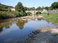
18th century bridge

.jpg)


Web links
- Location of the municipality
- Le Mas-d'Azil, history and places of interest - photos + info (French)
- Brief information about the community
- Le Mas-d'Azil on the IGN website
- Mas-d'Azil Church of Saint-Etienne
- Photos of the village church