
Moulis (Ariège)
|
Moulis Molins |
||
|---|---|---|
|
||
| region | Occitania | |
| Department | Ariège | |
| Arrondissement | Saint-Girons | |
| Canton | Couserans Ouest | |
| Community association | Couserans-Pyrénées | |
| Coordinates | 42 ° 58 ′ N , 1 ° 6 ′ E | |
| height | 412-1,608 m | |
| surface | 36.55 km 2 | |
| Residents | 761 (January 1, 2017) | |
| Population density | 21 inhabitants / km 2 | |
| Post Code | 09200 | |
| INSEE code | 09214 | |
.jpg) Notre-Dame church in Luzenac |
||

Moulis ( Occitan : Molins ) is a French commune with 761 inhabitants (as of January 1, 2017) in the Ariège department in the Occitanie region ; it belongs to the arrondissement of Saint-Girons , to the community association of Couserans-Pyrénées and to the canton of Couserans Ouest (until 2015: canton of Saint-Girons ). The inhabitants are called Moulisais / Moulisaises .
geography
Moulis is located around 77 kilometers south-southwest of the city of Toulouse in the west of the Ariège department. The community consists of the village of Moulis and numerous hamlets, scattered settlements and individual farms. Moulis and Luzenac are on the Lez river. Moulis is located within the Pyrénées Ariégeoises Regional Nature Park . Large parts of the community are mountainous and forested. The highest point in the municipality is the Tuc des Pelades . In terms of traffic, the community is located on the D618 far away from any major traffic connections.
Moulis is surrounded by the neighboring municipalities of Montégut-en-Couserans and Saint-Lizier in the north, Saint-Girons in the northeast and east, Eycheil and Lacourt in the east, Alos in the southeast, Bethmale in the south, Arrien-en-Bethmale in the southwest, Castillon- en-Couserans and Engomer in the west and Montgauch in the northwest.
history
The community has been settled for a long time. Finds from the Gallo-Roman period in the hamlet of Aubert prove this. In the Middle Ages, the place was within the province of Couserans, which in turn was part of the province of Gascony. The parish was part of the Saint-Girons district from 1793 to 1801. In addition, Moulis was within the canton of Saint-Girons from 1793 to 2015 . The parish has been assigned to the Arrondissement of Saint-Girons since 1801. The municipality of Moulis was created in its current form between 1790 and 1794 through the merger of the previous municipalities of Aubert , Luzenac , Montfaucon et Sour and Pouech with Moulis. A flood in June 1875 destroyed large parts of the districts on the Lez. In Moulis, both the church and the cemetery were flooded.
Population development
| year | 1793 | 1800 | 1831 | 1846 | 1872 | 1886 | 1954 | 1962 | 1968 | 1975 | 1982 | 1990 | 1999 | 2006 | 2014 |
| Residents | 1,977 | 1,690 | 2,703 | 2,594 | 2.159 | 2.144 | 1.003 | 1.010 | 1,013 | 847 | 828 | 798 | 759 | 796 | 785 |
| Sources: Cassini and INSEE | |||||||||||||||
Attractions
- Castle Château des Tronques above Moulis
- Roman tower (actually remnant of a mausoleum), a monument historique since 1905
- Church Saint-Jacques Aubert
- Notre-Dame chapel (-de-l'Assomption) from the 12th century in Luzenac, a monument historique since 1961
- Church Saint-Girons in Moulis
- Church Saint-Jean-Baptiste in Pouech
- Memorial to the Fallen
- former marble quarry near Aubert
- numerous caves (including Grotte du Portillou)
- numerous wayside crosses
- old watermill

Notre-Dame chapel in Luzenac
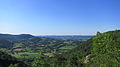
View of the Vallée de Lez near Moulis

View towards Moulis

Roman tower

former quarry near Aubert

View from Cap de la Pène into the Lez valley
.jpg)
.jpg)
.jpg)
.jpg)
.jpg)

Web links
- Information on cassini.ehess.fr
- Location of the place in France
- Moulis on the IGN side
- Photos of the three churches and the chapel
- Portrait and landmarks of the community
- Page with numerous photos of the Notre-Dame chapel
- Photos of other sights