
Balaguères
|
Balaguères Balaguèras |
||
|---|---|---|
|
||
| region | Occitania | |
| Department | Ariège | |
| Arrondissement | Saint-Girons | |
| Canton | Couserans Ouest | |
| Community association | Couserans-Pyrénées | |
| Coordinates | 42 ° 57 ' N , 1 ° 3' E | |
| height | 467-1,253 m | |
| surface | 17.84 km 2 | |
| Residents | 197 (January 1, 2017) | |
| Population density | 11 inhabitants / km 2 | |
| Post Code | 09800 | |
| INSEE code | 09035 | |
.JPG) Sainte-Catherine tower |
||

Balaguères ( Occitan : Balaguèras ) is a French commune with 197 inhabitants (as of January 1, 2017) in the Ariège department in the Occitanie region ; it belongs to the Arrondissement of Saint-Girons , to the community association of Couserans-Pyrénées and to the canton of Couserans Ouest (until 2015: Canton of Castillon-en-Couserans ). The inhabitants are called Balaguérois / Balaguéroises .
geography
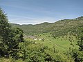
Balaguères is located around 79 kilometers southwest of the city of Toulouse in the west of the Ariège department on the border with the Haute-Garonne department. The community consists of the three villages Agert, Alas and Balagué as well as a few scattered settlements and individual farms. Alas is located on the Lez River. Balaguères is located within the Pyrénées Ariégeoises Regional Nature Park . Large parts of the community are mountainous and forested. The highest point in the municipality is the Sommet de Montreich . In terms of traffic, the municipality is located on the D204 far from any major traffic connections.
Balaguères is surrounded by the neighboring communities of Urau and Francazal (both in the Haute-Garonne department) in the north-west, Cazavet in the north, Montgauch and Moulis in the north-east, Engomer in the east and south-east, Cescau , Arrout , Argein and Villeneuve in the south and south-west and Buzan in the West.
history
In the Middle Ages, the place was within the rule Aspet, which in turn was part of the province of Couserans in Gascony. The parish was part of the Saint-Girons district from 1793 to 1801. In addition, Balaguères was from 1793 to 2015 within the canton of Castillon-en-Couserans . The parish has been assigned to the Arrondissement of Saint-Girons since 1801. The municipality of Balaguères was created between 1790 and 1794 through the merger of the previous municipalities of Agert , Alas and Balagué .
Population development
| year | 1793 | 1800 | 1821 | 1831 | 1851 | 1911 | 1921 | 1962 | 1968 | 1975 | 1982 | 1990 | 1999 | 2006 | 2014 |
|---|---|---|---|---|---|---|---|---|---|---|---|---|---|---|---|
| Residents | 1,379 | 731 | 955 | 1,289 | 1,308 | 779 | 643 | 314 | 314 | 267 | 223 | 209 | 192 | 194 | 199 |
| Sources: Cassini and INSEE | |||||||||||||||
Attractions
- Ruins of the tower of Sainte-Catherine from the 13th century
- Church Notre-Dame-de-l'Assomption in Agert (partly Romanesque)
- Church Saint-Pierre in Alas from the 16th century
- Saint Vincent Church in Balagué
- Memorial to the Fallen
- Rock garden Jardin de Pierres in Alas
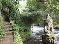
- Cave Grotte de Sainte-Catherine
- numerous wayside crosses
- Réseau Paloume , cave system

View of Agert (left) and Alas
View of Balagué

Partial view of Balagué
Rock garden in Alas

Cave Grotte de Sainte-Catherine

Saint Vincent village church in Balagué
.JPG)
.jpg)
.jpg)
_-_panoramio_(1).jpg)
.jpg)
.jpg)
Web links
- Statistics on cassini.ehess.fr
- Balaguères on the IGN side
- Photos of the three churches
- Portrait and landmarks of the community
- Page with numerous photos of the community