Sabarat
|
Sabarat Savarat |
||
|---|---|---|

|
|
|
| region | Occitania | |
| Department | Ariège | |
| Arrondissement | Saint-Girons | |
| Canton | Arize-Lèze | |
| Community association | Arize Lèze | |
| Coordinates | 43 ° 6 ′ N , 1 ° 23 ′ E | |
| height | 265-510 m | |
| surface | 9.50 km 2 | |
| Residents | 361 (January 1, 2017) | |
| Population density | 38 inhabitants / km 2 | |
| Post Code | 09350 | |
| INSEE code | 09253 | |
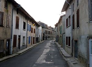
 Partial view of the village |
||
Sabarat ( Occitan Savarat ) is a French commune with 361 inhabitants (as of January 1, 2017) in the Ariège department in the Occitania region (previously Midi-Pyrénées ); it belongs to the arrondissement of Saint-Girons and the canton of Arize-Lèze .
location
Sabarat is located on the Arize River in the north of the Ariège department. The closest town is Pamiers , about 18 kilometers (as the crow flies) to the east ; the city of Toulouse is just under 70 kilometers to the north. The municipality is part of the Massif du Plantaurel and lies within the Pyrénées Ariégeoises Regional Natural Park .
The community consists of the village of Sabarat and individual farmsteads.
history
The dolmen of Peyré is evidence of settlement in the early days. The remains of a Celtic oppidum have also been found in the municipality. Historically, the place belongs to the Volvestre region within Languedoc. In the Middle Ages, Sabarat was part of the County of Foix . In 1060 a church Saint-Pierre de Molières is mentioned. The majority of the residents converted to the Reformed Church in the 16th century. In September 1625 a royal army of 14,000 men advanced to fight Calvinism. The inhabitants fled to the fortified city of Le Mas-d'Asil. In 1683, 370 of the 520 inhabitants are Protestants and only 150 are Catholics. Only with the re-Catholicization was a catholic church built again in 1688. The community belonged to the Mirepoix-Pamiers district from 1793 to 1801. In addition, it was from 1793 to 2015 part of the canton of Le Mas d'Azil (1793-1801 under the name of Canton Mas d'Azis ).
Population development
| year | 1793 | 1821 | 1831 | 1846 | 1856 | 1861 | 1881 | 1962 | 1968 | 1975 | 1982 | 1990 | 1999 | 2006 | 2012 |
| Residents | 629 | 622 | 699 | 830 | 823 | 725 | 678 | 348 | 327 | 305 | 279 | 304 | 284 | 337 | 340 |
| Sources: Cassini and INSEE | |||||||||||||||
In the 19th century the place had over 800 inhabitants at times. The increasing mechanization of agriculture in the first half of the 20th century led to a continuous decline in the number of inhabitants to the lowest level around 1980.
Attractions
- Dolmen and remains of an oppidum in Peyré
- Reformed Church (Temple) from the 18th century (restored in 1869/1870)
- Catholic village church of Sainte-Anne from 1688
- Half-timbered houses on the left bank of the Arize
- Observatory
Web links
- Location of the municipality
- Sabarat, history and sights - photos + information (French)
- Brief information about the community
- Sabarat on the IGN side
- Churches of the parish
- Photos of the village churches
