
Ercé
|
Ercé Èrce |
||
|---|---|---|
|
||
| region | Occitania | |
| Department | Ariège | |
| Arrondissement | Saint-Girons | |
| Canton | Couserans Est | |
| Community association | Couserans-Pyrénées | |
| Coordinates | 42 ° 51 ′ N , 1 ° 17 ′ E | |
| height | 574-1,905 m | |
| surface | 40.75 km 2 | |
| Residents | 539 (January 1, 2017) | |
| Population density | 13 inhabitants / km 2 | |
| Post Code | 09140 | |
| INSEE code | 09113 | |
 View of Ercé |
||

Ercé ( Occitan : Èrce ) is a French commune with 539 inhabitants (as of January 1, 2017) in the Ariège department in the Occitania region ; it belongs to the arrondissement of Saint-Girons , to the community association of Couserans-Pyrénées and to the canton of Couserans Est (until 2015: canton of Oust ). The inhabitants are called Ercéens / Ercéennes .
geography
Ercé is located around 85 kilometers south of the city of Toulouse in the west of the Ariège department. The municipality consists of the village of Ercé, numerous hamlets and scattered settlements as well as individual farms and is located on the Garbet river . The middle and upper sections of the Vallée du Garbet are part of the municipality. Ercé is located within the Pyrénées Ariégeoises Regional Nature Park . Large parts of the community are mountainous and forested. The highest point is La Pique (also called Mont Béas ) in the southeast of the municipality. In terms of traffic, the community is on the D32.
Ercé is surrounded by the neighboring communities of Aleu in the north, Biert and Massat in the northeast, Le Port in the east, Aulus-les-Bains in the south, Ustou in the southwest, Oust in the west and northwest and Soulan in the northwest.
history
In the Middle Ages, the place was within the province of Couserans, which in turn was part of the province of Gascony. The parish was part of the Saint-Girons district from 1793 to 1801. In addition, Ercé was within the Canton of Oust from 1793 to 2015 . The parish has been assigned to the Arrondissement of Saint-Girons since 1801.
Population development
| year | 1793 | 1800 | 1831 | 1846 | 1851 | 1881 | 1891 | 1911 | 1921 | 1936 | 1946 | 1962 | 1968 | 1975 | 1982 | 1990 | 1999 | 2006 | 2014 |
| Residents | 3,245 | 3,780 | 3,256 | 3,945 | 3,232 | 3,106 | 2,630 | 2,634 | 1,703 | 1,584 | 1,043 | 1,016 | 1.012 | 990 | 750 | 566 | 532 | 529 | 533 |
| Sources: Cassini and INSEE | |||||||||||||||||||
Attractions
- former castle, now the Saint-Philippe hospice
- Church in Cominac
- Church Notre-Dame-de-l'Assomption from the 12th century in Ercé, since 1964, a historique Monument
- Iron wayside cross crowned by a weathercock, a monument historique since 1964
- Notre-Dame-Pitié chapel in Le Calvaire
- Saint-Pierre chapel from the 12th century, a monument historique since 1979
- Remains of the church of Labouche in Les Jammets
- Mill Moulin du Ressec
- Museum Musée des montreurs d'ours on the history of the dancing bears (attitude)
- Memorial to the Fallen
- numerous other wayside crosses
- More Attractions

Notre-Dame-de-l'Assomption church in Ercé

Saint-Pierre Chapel

Cominac Church
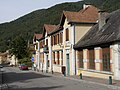
Town center with Mairie (town hall)

Calvary

Wayside cross with weathercock

Barn with dovecote
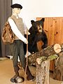
Scene in the Musée des Montreurs d'ours
.jpg)


Web links
- Information about Ercé at cassini.ehess.fr
- Location of the place in France
- Ercé on the IGN website
- Photos of the churches and the chapel
- Portrait and landmarks of the community
- Page with numerous photos by Ercé
- more photos of Ercé and its districts