
Unterbreizbach
| coat of arms | Germany map | |
|---|---|---|

|
Coordinates: 50 ° 49 ' N , 9 ° 59' E |
|
| Basic data | ||
| State : | Thuringia | |
| County : | Wartburg district | |
| Height : | 240 m above sea level NHN | |
| Area : | 30.03 km 2 | |
| Residents: | 3417 (Dec. 31, 2019) | |
| Population density : | 114 inhabitants per km 2 | |
| Postcodes : | 36414, 36404 (Sünna) |
|
| Area code : | 036962 | |
| License plate : | WAK, SLZ | |
| Community key : | 16 0 63 078 | |
| LOCODE : | DE UBB | |
| Community structure: | 3 districts | |
| Address of the municipal administration: |
Heinrich-Heine-Str. 3 36414 Unterbreizbach |
|
| Website : | ||
| Mayor : | Roland Ernst (independent) | |
| Location of the community of Unterbreizbach in the Wartburg district | ||
  |
||


Unterbreizbach is a municipality in the Wartburg district in Thuringia .
geography
Unterbreizbach is located in the lower Ulstertal . The name-giving Breizbach flows into the community as the left tributary, colloquially known by the inhabitants as "the Bach". Striking elevations are the Lohberg ( 322.6 m above sea level ) in the east and the Ulsterberg ( 487.2 m above sea level ) in the south as well as the huge potash heap between Hattdorf and Unterbreizbach. The southern districts are located in the catchment area of the Oechse with the left tributary Sünna. The Dietrichsberg ( 668.9 m above sea level ) and the Sattelsberg ( 464.1 m above sea level ) border this side valley.
| Philippsthal (Werra) (Hesse) | ||
| Hohenroda (Hesse) |
.svg)
|
Vacha |
| Buttlar |
Community structure

The municipality has the following districts (population on June 30, 2009):
- Unterbreizbach with Räsa
- Pferdsdorf (incorporated on August 1, 1996)
-
Sünna with the court communities
- Deicheroda (57 inhabitants; incorporated into Sünna on April 1, 1974),
- Mosa (67 inhabitants),
- Mühlwärts (48 inhabitants),
- Hüttenroda (51 inhabitants; with Hofwiesen ) (incorporated on August 1, 1996),
- the currently uninhabited farmstead Poppenberg .
Natural monuments
The sessile oak on the Kornberg, known to the population as the thick oak , was designated as a natural monument in 1956 . The Sophienlinde in front of the church, a winter linden tree that is over 150 years old , was placed under protection in 1994.
history
The community was first mentioned in documents in 1390 as Gut zu Nieder-Breyzbach . The village in the soft landscape of the city of Vacha (in the Hessian Amt Vacha ) was dominated by agriculture until the beginning of the 20th century. The local nobility and their successors from the surrounding communities of Rasdorf , Mansbach , Völkershausen and Buttlar have left no structural traces in the village. The church in Unterbreizbach is a Protestant branch church of the Vacha town church and was consecrated in 1773. In the historic center around the church, half-timbered houses typical of the region dominate the townscape.
19th century
In 1816 the place came from Kurhessen to the Grand Duchy of Saxony-Weimar-Eisenach . In 1879, based on the census of 1875, statistical information on the place Unterbreizbach was published, the place had 83 houses and 484 inhabitants on the reference date. The size of the field was 580.3 ha - of which courtyards and gardens 9.2 ha, meadows 91.5 ha, arable land 287.2 ha. Forest 156.2 ha, ponds, streams and rivers 5.7 ha. Trifte, wasteland and orchards accounted for 30.4 hectares. The livestock was 18 horses, 265 cattle, 360 sheep, 126 pigs and 33 goats as well as 56 bee colonies.
20th century
In 1906, Unterbreizbach was connected to rail traffic and a station on the newly opened Ulstertalbahn , which connected Vacha with Geisa and later with Tann (Rhön) .
On April 2, 1945, the village was handed over to the approaching US troops without a fight. When they were attacked by a dispersed SS unit, the place was still under fire and 45 buildings in the town center including the station building were destroyed.
In the GDR, the situation in the immediate vicinity of the border meant that Unterbreizbach was in the 5 km exclusion zone . Residents had a corresponding note in their identity cards, and visitors had to apply for a pass that allowed them to stay in the restricted area.
Economy and Infrastructure
Mining
The economy in the municipality is shaped by the potash industry. The chemical factory of K + S AG is located in the core town of Unterbreizbach . Here, the raw salt from the mine is processed into fertilizers. Between Sünna and Buttlar at the B84 is at Mühlwärts of belonging to the work Unterbreizbach shaft II , which mainly for the Seilfahrt of Kali-mate is used. The locations in Hattorf , Wintershall , Unterbreizbach and the Merkers visitor mine have together formed the Werra network in the Werra potash district since 1997 . Their underground geographic extent is comparable to the urban area of Munich.
On October 1, 2013, during an extraction blast at a depth of 900 meters, the nano-explosion of a dust / salt / CO₂ mixture caused a carbonic acid explosion, killing three miners .
In Unterbreizbach there was a 200 meter high chimney that belonged to the power plant and the kieserite plant of the local K + S plant. After the system was converted to natural gas, it was shortened to 94 meters in 2001/2002 with the help of a special excavator in order to minimize the risk of condensation forming in the chimney, which can lead to corrosion damage.
Commercial areas
- The Im Wolfsgraben industrial park is located north of Unterbreizbach on the state border with Hesse. It has a total area of 7.8 hectares (as of 2009), a further 35 hectares are reserved for expansion.
- The An der B84 industrial park is located on the northern outskirts of Sünna. It has a total area of 5.7 hectares (as of 1998).
Wastewater treatment
The town of Unterbreizbach has a central sewage treatment plant to which the districts of Räsa and Pferdsdorf are also connected. The Sünna district is connected to the sewage treatment plant in Vacha . Due to the small number of inhabitants in the districts of Deicheroda, Mosa, Hüttenroda, Mühlwärts and Poppenberg, there is no permanent connection to the central wastewater treatment for these settlements.
traffic
- Wartburgmobil bus lines connect Unterbreizbach with the surrounding communities
- Unterbreizbach has a train station that was once located on the Ulstertal Railway . However, there is only a rail connection via the mine connection railway operated by K + S to Heimboldshausen and the Werra Valley Railway . The route is used exclusively for freight traffic.
- The district of Sünna had a breakpoint at the section of the Bad Salzungen-Unterbreizbach railway in the section Vacha -Unterbreizbach built to bypass the former inner-German border , which was operated by passenger traffic between 1954 and 1956.
- The federal highway 84 runs through Sünna. Via the Thuringian state road 2604 and the district road 8 in the East Hessian district of Hersfeld-Rotenburg there is a connection to the federal highway 62 and from there to the federal highway 4 .
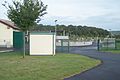
Wastewater treatment plant Unterbreizbach
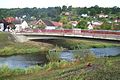
Ulster Bridge

Unterbreizbach potash works
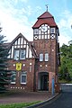
Clubhouse (former porter building of the potash works)

Partial view with fire brigade and winding tower

Hall of the culture house


Bike trails
The following cycle paths run through the municipality :
- The Hessen Railway Cycle Route leads from Hanau on former railway lines for approx. 250 km through the Vogelsberg and the Rhön and ends in Bad Hersfeld .
- The Ulstertal cycle path as part of the Rhön cycle path . This has a total length of 180 km and leads from Bad Salzungen to Hammelburg , through all three federal states of the Rhön : Bavaria , Hesse and Thuringia .
education
The state regular school on Ulsterberg is located in the district of Räsa , the associated elementary school can be found in Sünna. There are communal day-care centers in Unterbreizbach, Sünna and Pferdsdorf.
societies
The most important sports club is SV Kali Unterbreizbach , whose main activities are football. The men's team plays in the West Thuringian regional league of the Thuringian Football Association, the women's team in the regional league.
politics
Municipal council
The local council of Unterbreizbach consists of 16 council members:
(As of: local election on May 26, 2019 )
mayor
- 1990-2006: Meinhard Pforr
- since 2006: Roland Ernst
The full-time mayor Roland Ernst (independent) was confirmed in office on April 22, 2012 with 84.9 percent of the votes and was elected for a further six years in 2018.
coat of arms
Unterbreizbach
Description: “Diagonally quartered with gold and red. Field 1: a red Luther rose with a golden slug , field 2: a silver horse head turned left , field 3: a silver butte with three golden barrel hoops and two silver straps, field 4: a black mallet and Iron . "
Coat of arms of the Unterbreizbach district
The coat of arms was designed by the heraldist Uwe Reipert . Blazon : "Split of red and gold, in front a silver butte with three golden barrel hoops and two golden shoulder straps, behind three black hunting horns set in the cross ."
Sünna district coat of arms
The coat of arms was designed by the heraldist Uwe Reipert and was approved on May 25, 1993.
Blazon : “Split by silver and green diagonally right; above a red five-petalled rose, in the middle of which is a gold heart covered with a black high cross; below a halved silver wheel axle. "
The municipality of Sünna is located on one of the most important old trade routes, on the former main axis Mainz or Frankfurt - Erfurt or Leipzig. This developmental characteristic is expressed in the coat of arms through the depiction of half a wheel axle. The rose that appears in the coat of arms symbolizes the bond between the five districts of the municipality with its five petals. It is a form of the Luther rose . In addition, it points to the denominational evangelical ties of the place. The first Protestant pastor was introduced to the Sünna church office as early as 1525.

Coat of arms of the horse village

Sünna local coat of arms

Coat of arms of Unterbreizbach


partnership
There is a partnership with Haltern am See in North Rhine-Westphalia .
literature
- Michael Knauf: History of the railway line Vacha - Unterbreizbach 1952–2000 . Rockstuhl Verlag , Bad Langensalza, 2008, ISBN 978-3-86777-038-5
Web links
Individual evidence
- ^ Population of the municipalities from the Thuringian State Office for Statistics ( help on this ).
- ↑ Official topographic maps of Thuringia 1: 10,000. Wartburgkreis, district of Gotha, district-free city of Eisenach . In: Thuringian Land Survey Office (Hrsg.): CD-ROM series Top10 . CD 2. Erfurt 1999.
- ↑ Information . In: District Office Wartburgkreis (Ed.): Official Gazette of the Wartburgkreis from 10 August 2010 . Bad Salzungen 2010, p. 14 .
- ^ StBA: Changes in the municipalities in Germany, see 1996
- ↑ Federal Statistical Office (Ed.): Municipalities 1994 and their changes since 01.01.1948 in the new federal states . Metzler-Poeschel, Stuttgart 1995, ISBN 3-8246-0321-7 .
- ^ StBA: Changes in the municipalities in Germany, see 1996
- ^ Biedermann: Natural monuments in the Wartburg district; District Office Wartburgkreis, 2014, page 62
- ^ Biedermann: Natural monuments in the Wartburg district; District Office Wartburgkreis, 2014, page 63
- ^ C. Kronfeld: Regional studies of the Grand Duchy of Saxony-Weimar-Eisenach . Second part. Topography of the country. Hermann Böhlau, Weimar 1879, Beuernfeld, p. 31 .
- ↑ Michael Knauf, Markus Schmidt: The history of the Ulstertal Railway 1981-1996; Verlag Rockstuhl, Bad Langensalza 2018, ISBN 978-395-966-295-6 , page 99f.
- ↑ www.kali-gmbh.com
- ↑ Osthessen News : Explosion at K + S: three missing people found dead on October 1, 2013
- ↑ Business parks in the Wartburg region. In: Wartburgkreis-Online. Archived from the original on May 15, 2011 ; Retrieved February 18, 2010 .
- ↑ District Office Wartburgkreis (Ed.) The business location Wartburgkreis - City of Eisenach. Info folder Bad Salzungen / Eisenach 1998. p. 20
- ↑ (m): "Verpulverte millions" and "golden lid" - Unterbreizbach and the topic of sewage. Südthüringer Zeitung (editorial office Bad Salzungen), March 25, 2010, accessed on September 30, 2012 : “An overall concept for the waste disposal area must be resolved, ... including the promotion of small wastewater treatment plants in the areas that have now been exempted from the obligation to dispose of waste water. Sooner or later the Lower Water Authority will demand the construction of fully biological systems in these areas. Within the municipality of Unterbreizbach, the permanent liberation concerns Mühlwärts and Poppenberg. Deicheroda, Hüttenroda and Mosa had a local canal and remained public areas. However, it is more economical there if the property owners build a fully biological system with a connection to a transmission into the public sewer. "
- ↑ City council election 2019 in Thuringia - preliminary result. The regional returning officer, accessed on June 4, 2019 .
- ↑ New Thuringian Wappenbuch Volume 3, page 105; Publisher: Arbeitsgemeinschaft Thüringen eV 1998 ISBN 3-9804487-3-8
Office of Creuzburg | Bad Liebenstein | Bad Salzungen | Barchfeld-Immelborn | Berka vd Hainich | Bischofroda | Buttlar | Dermbach | Empfertshausen | Frankenroda | Geisa | Barley ground | Barley | Hallings | Hörselberg-Hainich | Krauthausen | Krayenberg Community | Lauterbach | Leimbach | Moorgrund | Nazza | Oxen | Ruhla | Schleid | Seebach | Treffurt | Unterbreizbach | Vacha | Weilar | Werra-Suhl Valley | Wiesenthal | Wutha Farnroda
Deicheroda | Hüttenroda with courtyard meadows | Mühlwärts | Mosa | Horse village | Poppenberg | Räsa | Unterbreizbach | Sünna