
Claret (Alpes-de-Haute-Provence)
| Claret | ||
|---|---|---|

|
|
|
| region | Provence-Alpes-Cote d'Azur | |
| Department | Alpes-de-Haute-Provence | |
| Arrondissement | Forcalquier | |
| Canton | Seyne | |
| Community association | Gap-Tallard-Durance | |
| Coordinates | 44 ° 22 ′ N , 5 ° 57 ′ E | |
| height | 528-1,254 m | |
| surface | 21.04 km 2 | |
| Residents | 269 (January 1, 2017) | |
| Population density | 13 inhabitants / km 2 | |
| Post Code | 05110 | |
| INSEE code | 04058 | |
 Claret |
||

Claret is a French municipality with 269 inhabitants (at January 1, 2017) in the department of Alpes-de-Haute-Provence in the region Provence-Alpes-Cote d'Azur . It belongs to the Arrondissement Forcalquier and the Canton of Seyne .
geography
The municipality is located in the valley of the Durance . The river delimits the village of Ventavon , Monêtier-Allemont and Vitrolles in the Hautes-Alpes department . The other neighboring communities are Curbans , Melve and Thèze . Claret is located in the French Maritime Alps with the following mountain peaks and mountain ranges:
- Tete de Boursier, 1256 m
- Le Collet du Vicaire, 617 m
- Le Signavour, 818 m
- Le Collet du Vicaire, maximum 857 m in Claret; The border to Melve runs over this elevation .
- Le Peyrouard, 1076 m
- Montagne de Chaillans, 1089 m
- Crêt de la Pare
Population development
| year | 1968 | 1975 | 1982 | 1990 | 1999 | 2006 | 2017 |
| Residents | 145 | 140 | 132 | 189 | 249 | 227 | 269 |
Notre-Dame de la Visitation chapel

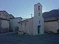
The Saint-Pierre church

Mairie Claret
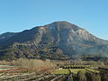
Tete de Boursier


Web links
Commons : Claret - collection of images, videos and audio files