
Dracy-Saint-Loup
| Dracy-Saint-Loup | ||
|---|---|---|
|
||
| region | Bourgogne-Franche-Comté | |
| Department | Saône-et-Loire | |
| Arrondissement | Autun | |
| Canton | Autun-1 | |
| Community association | Grand Autunois Morvan | |
| Coordinates | 47 ° 1 ′ N , 4 ° 20 ′ E | |
| height | 289-371 m | |
| surface | 21.2 km 2 | |
| Residents | 570 (January 1, 2017) | |
| Population density | 27 inhabitants / km 2 | |
| Post Code | 71400 | |
| INSEE code | 71184 | |
| Website | http://www.mairie-dracy-saint-loup.fr/ | |
 Town hall (Mairie) of Dracy-Saint-Loup |
||

Dracy-Saint-Loup is a French municipality with 570 inhabitants (as of January 1 2017) in the department of Saone-et-Loire in the region of Bourgogne Franche-Comté . The municipality belongs to the Arrondissement of Autun and the canton of Autun-1 (until 2015: canton of Autun-Nord ).
geography
Dracy-Saint-Loup is located about seven kilometers north-northeast of Autun am Drée and Arroux . Dracy-Saint-Loup is surrounded by the neighboring communities of Cordesse in the north, Igornay in the north and northeast, Saint-Léger-du-Bois in the east and northeast, Curgy in the east and southeast, Autun in the south and southwest, and Saint-Forgeot in the west Southwest and Reclesne in the northwest.
Population development
| 1962 | 1968 | 1975 | 1982 | 1990 | 1999 | 2006 | 2013 | |
|---|---|---|---|---|---|---|---|---|
| 546 | 480 | 477 | 575 | 663 | 615 | 558 | 600 | |
| Sources: Cassini and INSEE | ||||||||
Attractions
- Saint-Loup church
- Dracy-Saint-Loup castle from the 17th century, monument historique since 2011
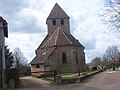
Saint-Loup church

Dracy-Saint-Loup Castle


Personalities
- Marius Canard (1888–1982), historian and orientalist
Web links
Commons : Dracy-Saint-Loup - Collection of images, videos and audio files