Saint-Didier-sur-Arroux
| Saint-Didier-sur-Arroux | ||
|---|---|---|
|
|
||
| region | Bourgogne-Franche-Comté | |
| Department | Saône-et-Loire | |
| Arrondissement | Autun | |
| Canton | Autun-2 | |
| Community association | Grand Autunois Morvan | |
| Coordinates | 46 ° 50 ' N , 4 ° 7' E | |
| height | 263-470 m | |
| surface | 27.94 km 2 | |
| Residents | 232 (January 1, 2017) | |
| Population density | 8 inhabitants / km 2 | |
| Post Code | 71190 | |
| INSEE code | 71407 | |
Saint-Didier-sur-Arroux is a French municipality with 232 inhabitants (as of January 1 2017) in the department of Saone-et-Loire in the region of Bourgogne Franche-Comté (before 2016 Burgundy ). The municipality belongs to the Arrondissement of Autun and the canton of Autun-2 (until 2015 canton of Saint-Léger-sous-Beuvray ).
geography
Saint-Didier-sur-Arroux is located about 20 kilometers southwest of Autun in the Morvan Regional Nature Park . The Arroux limits the municipality to the east. Saint-Didier-sur-Arroux is surrounded by the neighboring communities of Poil in the north and north-west, La Comelle in the north, Étang-sur-Arroux in the east and north-east, Saint-Nizier-sur-Arroux in the east and south-east, Thil-sur-Arroux in the south, Luzy in the southwest and Millay in the west.
Population development
| 1962 | 1968 | 1975 | 1982 | 1990 | 1999 | 2006 | 2013 | |
|---|---|---|---|---|---|---|---|---|
| 485 | 434 | 353 | 285 | 281 | 273 | 253 | 241 | |
| Sources: Cassini and INSEE | ||||||||
Attractions
- Remains of Gallo-Roman settlement
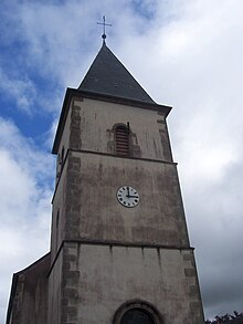
- Saint Didier church from the 19th century
- Jouleaux Castle from the 15th / 16th centuries century
- 19th century Charency Castle
- Gissy Castle
- Saint-Didier-sur-Arroux castle from the 17th century
- Varillon Castle
Personalities
- Hugues Nardon (1768–1812), grandee of Spain

