
La Boulaye
| La Boulaye | ||
|---|---|---|
|
||
| region | Bourgogne-Franche-Comté | |
| Department | Saône-et-Loire | |
| Arrondissement | Autun | |
| Canton | Autun-2 | |
| Community association | Grand Autunois Morvan | |
| Coordinates | 46 ° 45 ' N , 4 ° 8' E | |
| height | 256-481 m | |
| surface | 13.86 km 2 | |
| Residents | 100 (January 1, 2017) | |
| Population density | 7 inhabitants / km 2 | |
| Post Code | 71320 | |
| INSEE code | 71046 | |

La Boulaye is a French commune of 100 people (at January 1, 2017) in Saône-et-Loire in the Région Bourgogne Franche-Comté (before 2016 Bourgogne ). The municipality belongs to the Arrondissement of Autun and the canton of Autun-2 ( Mesvres until 2015 ).
geography
La Boulaye is located about 28 kilometers south-southwest of the city center of Autun am Arroux . La Boulaye is surrounded by the neighboring municipalities of Charbonnat in the north, Dettey in the east and northeast, Saint-Eugène in the east and southeast, Toulon-sur-Arroux in the south and Montmort in the west.
Population development
| year | 1962 | 1968 | 1975 | 1982 | 1990 | 1999 | 2006 | 2013 |
| Residents | 123 | 121 | 111 | 134 | 148 | 122 | 117 | 105 |
| Source: Cassini and INSEE | ||||||||
Attractions
- Sainte-Madeleine church
- Dashang Kagyu Ling Buddhist temple
- La Boulaye Castle
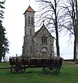
Sainte-Madeleine church

Buddhist temple


Personalities
- Gustave Duverne (1891–1967), automobile pioneer
Web links
Commons : La Boulaye - collection of images, videos and audio files