
Poil
| Poil | ||
|---|---|---|
|
||
| region | Bourgogne-Franche-Comté | |
| Department | Nièvre | |
| Arrondissement | Château-Chinon (Ville) | |
| Canton | Luzy | |
| Community association | Bazois Loire Morvan | |
| Coordinates | 46 ° 52 ' N , 4 ° 4' E | |
| height | 297-522 m | |
| surface | 27.02 km 2 | |
| Residents | 138 (January 1, 2017) | |
| Population density | 5 inhabitants / km 2 | |
| Post Code | 58170 | |
| INSEE code | 58211 | |
| Website | http://www.poil-morvan.fr/ | |
 Town hall (Mairie) of Poil |
||

Poil is a commune with 138 inhabitants (at January 1, 2017) in the department of Nièvre in the region of Bourgogne Franche-Comté (before 2016 Bourgogne ). It belongs to the arrondissement of Château-Chinon (Ville) and the canton of Luzy . The inhabitants are called Pictiens .
geography
Poil is about 70 kilometers east-southeast of Nevers on the edge of the Morvan . Poil is surrounded by the neighboring communities Larochemillay in the north and west, Saint-Léger-sous-Beuvray in the north and north-east, La Comelle in the east, Saint-Didier-sur-Arroux in the south and south-east and Millay in the south-west.
Population development
| year | 1962 | 1968 | 1975 | 1982 | 1990 | 1999 | 2006 | 2011 | 2016 |
|---|---|---|---|---|---|---|---|---|---|
| Residents | 366 | 302 | 241 | 228 | 206 | 189 | 156 | 154 | 140 |
|
|
|||||||||
Attractions
- Oppidum Bibracte
- Saint-Romain church from the 16th century, alterations from the 19th century
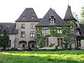
- Le Mousseau castle from the 16th century
- Pierrefitte Castle
- Concley Castle from the 18th century
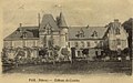
- Ettevaux Castle from the 18th century
- Thil Castle from the 15th century
- 18th century castle Villette
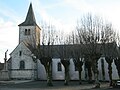
Saint Romain Church
Castle Concley

Ettevaux Castle

Le Mousseau castle
Pierrefitte Castle

Thil Castle

Villette Castle
_-_Eglise,_vue_est.JPG)
.jpg)
_-_Ch%C3%A2teau_d%27Ettevaux_-_Carte_postale.jpg)


literature
- Le Patrimoine des Communes de la Nièvre. Volume 2, Flohic Editions, Charenton-le-Pont 1999, ISBN 2-84234-054-X , pp. 591-592.
Web links
Commons : Poil (Nièvre) - Collection of images, videos and audio files