
Saint-Honoré-les-Bains
| Saint-Honoré-les-Bains | ||
|---|---|---|

|
|
|
| region | Bourgogne-Franche-Comté | |
| Department | Nièvre | |
| Arrondissement | Château-Chinon (Ville) | |
| Canton | Luzy | |
| Community association | Bazois Loire Morvan | |
| Coordinates | 46 ° 54 ′ N , 3 ° 50 ′ E | |
| height | 222-555 m | |
| surface | 25.12 km 2 | |
| Residents | 744 (January 1, 2017) | |
| Population density | 30 inhabitants / km 2 | |
| Post Code | 58360 | |
| INSEE code | 58246 | |
| Website | http://www.st-honore-les-bains.com/ | |
 View of Saint-Honoré-les-Bains |
||

Saint-Honoré-les-Bains is a French commune with 744 inhabitants (at January 1, 2017) in the department of Nièvre in the region of Bourgogne Franche-Comté (before 2016 Bourgogne ). It belongs to the arrondissement of Château-Chinon (Ville) and the canton of Luzy (until 2015 Moulins-Engilbert ). The inhabitants are called Saint-Honoréens .
geography
Saint-Honoré-les-Bains is located about 55 kilometers east-southeast of Nevers on the edge of the Morvan . Saint-Honoré-les-Bains is surrounded by the neighboring communities of Préporché in the north, Villapourçon in the east and northeast, Sémelay in the south and Vandenesse in the west.
Population development
| year | 1962 | 1968 | 1975 | 1982 | 1990 | 1999 | 2006 | 2011 | 2016 |
|---|---|---|---|---|---|---|---|---|---|
| Residents | 993 | 977 | 958 | 831 | 754 | 763 | 846 | 835 | 751 |
|
|
|||||||||
Attractions
- Saint-Loup church from the 12th century
- Benedictine priory of Saint Honorat, founded in 1106
- Sacre-Cœur Chapel, built in 1860
- Thermal baths of Saint-Honoré-les-Bains
- La Montagne Castle
- Manor of La Quedre
- Manor of Le Gué
- Resistance Museum
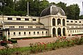
Thermal baths of Saint-Honoré-les-Bains
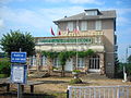
Resistance Museum


literature
- Le Patrimoine des Communes de la Nièvre. Volume 2, Flohic Editions, Charenton-le-Pont 1999, ISBN 2-84234-054-X , pp. 674-680.
Web links
Commons : Saint-Honoré-les-Bains - Collection of images, videos and audio files