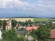
Dubodiel
| Dubodiel | ||
|---|---|---|
| coat of arms | map | |

|
|
|
| Basic data | ||
| State : | Slovakia | |
| Kraj : | Trenčiansky kraj | |
| Okres : | Trenčín | |
| Region : | Stredné Považie | |
| Area : | 20.191 km² | |
| Residents : | 954 (Dec. 31, 2019) | |
| Population density : | 47 inhabitants per km² | |
| Height : | 310 m nm | |
| Postal code : | 913 23 | |
| Telephone code : | 0 32 | |
| Geographic location : | 48 ° 46 ' N , 18 ° 7' E | |
| License plate : | TN | |
| Kód obce : | 505978 | |
| structure | ||
| Community type : | local community | |
| Administration (as of November 2018) | ||
| Mayor : | Anton Prechádzka | |
| Address: | Obecný úrad Dubodiel č. 33 913 23 Dubodiel |
|
| Website: | www.dubodiel.sk | |
| Statistics information on statistics.sk | ||
Dubodiel (until 1927 Slovak and "Dubový Diel"; Hungarian Trencséntölgyes - to 1902 Dubodjel ) is a municipality in the north- west of Slovakia with 954 inhabitants (December 31, 2019) and is part of the Trenčín District , part of the kraj Trenčiansky .
geography
The municipality is located in the northernmost part of the hilly Nitrianska pahorkatina and thus also the Slovakian Danube lowlands , at the transition to the western Považský Inovec mountains and is almost exactly east of its highest mountain, Inovec ( 1042 m nm ). The Inovec flows through the village in the catchment area of the Bebrava . The center of the village lies at an altitude of 310 m nm and is 16 kilometers from Bánovce nad Bebravou and 20 kilometers from Trenčín .
Neighboring municipalities are Veľká Hradná in the north, Malá Hradná in the east, Veľké Držkovce and Cimenná in the southeast, Zlatníky in the south, Selec in the west and Trenčianske Jastrabie in the northwest.
history
Dubodiel was first mentioned in writing as Dubowydel in 1439 and was then part of the territory of Trenčín Castle . In 1598 there were 41 houses in the village, in 1720 it was inhabited by 23 taxpayers. In 1828 there were 82 houses and 677 inhabitants, whose main sources of income were agriculture, pottery and sometimes handicrafts. There were water mills and saws, a brewery and a distillery.
The municipality in Trenčín County belonged to the Kingdom of Hungary until 1918 and then became part of Czechoslovakia or now Slovakia. During the Second World War , the inhabitants supported the Czechoslovak partisans, and because of their participation in the Slovak National Uprising , part of the population was shot by the German armed forces or taken to concentration camps.
population
According to the 2011 census, 920 inhabitants lived in Dubodiel, of which 892 were Slovaks , 2 Germans and one Moravian and one Czech . 24 residents gave no information on ethnicity .
822 residents committed themselves to the Roman Catholic Church, 10 residents to the Evangelical Church AB and one resident to the Orthodox Church; 3 residents professed a different denomination. 39 inhabitants had no denomination and the denomination of 45 inhabitants was not determined.
Buildings and monuments
- Ruins of a medieval castle
- Baroque style chapel with a bell tower
- Country castle from 1938
Individual evidence
- ↑ Results of the 2011 census (Slovak) ( Memento of the original from March 5, 2016 in the Internet Archive ) Info: The archive link was inserted automatically and has not yet been checked. Please check the original and archive link according to the instructions and then remove this notice.
Web links
- Entry on e-obce.sk (Slovak)

