
Volga (federal district)
| Volga Federal District | |
|---|---|
 .svg) |
|
| Area : | 1,038,000 km² |
| Residents : | 29,636,574 (2017) |
| Population density : | 28.58 inhabitants / km² |
| Administrative headquarters : | Nizhny Novgorod |
The Volga Federal District ( Russian: Приволжский федеральный округ , Priwolschski federalny okrug ) is an administrative unit ( federal district ) in Russia (see Federal structure of Russia ) on the Volga . The administrative seat is in Nizhny Novgorod . The Volga Federal District was established by presidential decree on May 13, 2000. It consists of 14 federal subjects of the Russian Federation.
geography
The territory of the federal district has a share of 6.06 percent of the territory of the Russian Federation. The federal district has no access to the sea and is located in the center of Russia. The territory has a high proportion of agricultural land and has high hydropower resources. Over a distance of 3,500 kilometers, “Mother Volga ”, as the Russians call Europe's longest river, flows through Russia in a wide arc - most of it in the federal district of the same name. The Volga is the life and transport artery of a region that is of enormous importance for Russian and Soviet history. The proximity to the Ural federal districts in the east and Central Russia in the west ensure a high level of economic exchange with the rest of the country. In the south the district borders on Kazakhstan , in the southwest on the Federal District of Southern Russia and in the north on the Federal District of Northwestern Russia .
The relief consists of a flat, slightly undulating plain and is covered in the northern half of the circle with broad glacial deposits . A gentle hill plateau up to 350 meters high stretches from north to south along the right west bank of the Volga. Historically interesting rock caves occur in the foothills of the Urals ; they are considered the region's natural wonders. There are relatively few high-grade mineral deposits in the federal district area. Petroleum and sulfur deposits are of particular national importance. Most of the forests are concentrated in the north of the district, especially around Nizhny Novgorod and Kirov Oblast . Both areas are more than 50 percent forested. The average forest area in the southern part of the region is only eight percent. The climate here is more continental than around Moscow. The snow cover is at least five months. The average temperature in January is −16 degrees Celsius. Summer can have warm periods in the north and hot periods in the south. The average temperature in July in Nizhny Novgorod is +18 degrees Celsius, and near Saratov +20 degrees Celsius. The absolute temperature records in Kazan were −47 degrees Celsius for the winter and +38 degrees Celsius for the summer. The precipitation values in the north of the region are around 500–600 millimeters per year and in the south only around 400 millimeters per year. The soils are primarily alfisole soils in the north, and black earths and aridisole semi- desert in the south. The northern third of the federal district is in the coniferous and mixed forest zone , while the southern two thirds is in the forest-steppe and steppe zone . Some rare plants and types of vegetation are found on the west bank of the Volga on chalk cliffs. There are a large number of nature reserves in the region. There are 14 zapovedniks , 8 national parks and 4 wildlife sanctuaries.

The Nugusch in the autonomous republic of Bashkortostan.

Single hill in the steppe of Bashkortostan
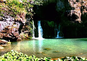
Waterfall in Bashkortostan

Foothills of the Jamantau


.jpg)

The Volga Federal District is home to 9 of the 21 largest cities in Russia. Only the Tolyatti car city in the Samara region is not the seat of a regional parliament. The largest city and capital of the district is Nizhny Novgorod with almost 1.3 million inhabitants. During the Soviet era it was still the third largest city in Russia after Moscow and Leningrad, but today it ranks fifth in the population ranking behind Novosibirsk and Yekaterinburg . Almost all the important cities of the federal district are on the Volga: the district capital Nizhny Novgorod, where the river enters the region from the north, Kazan and Samara, where the RKZ Progress company manufactures the Soyuz launch vehicles.
history

After the conquest of the Kazan Khanate in 1552 and the Astrakhan Khanate in 1556 by the Moscow Tsar Ivan IV , the lower and middle Volga runners also came under Russian rule and were henceforth settled by Russian colonizers. The Turk- and Finnish-speaking population resident there for centuries, the Mari , the Udmurts , the Chuvashes , Mordvins and Tatars as well as the Nogai and, since the 17th century, the Western Mongolian Kalmyks, were subject to profound changes.
These changes also applied to the expanding Russian state and the Russians . Both the function of the area as a hub between Orient and Occident, as well as the role of the Volga Tatars as cross-border commuters between Europe and Asia influenced the Russian efforts to dominate the area in the long term. With the conquest of the central Volga, the previously ethnically homogeneous Russian state developed into a multi-ethnic empire.
At the end of the 16th century, the fortress or colonial cities of Simbirsk , Samara and Saratov were founded on the lower Volga, but broad rural colonization did not begin in the area until the 17th and 18th centuries. At the same time, a planned population policy for this period began, so immigrants from Europe were also settled, for example the later Volga Germans .
The new trade route across the Caspian Sea to Persia and India aroused the interest of Western European merchants on the one hand and led to an economic revival in domestic trade on the other. A systematic exploration of the Volga region did not begin until the 17th century, when Adam Olearius made cartographic knowledge useful and necessary for navigation accessible to subsequent Persia travelers with his printed map of the Volga, and provided basic information about the cities and peoples on the Volga.
It was not until the 18th century that the Volga was seen more strongly in terms of its regional significance and its importance for Russia. At the beginning of the 18th century Russia had risen to become a major European power and changed its geopolitical orientation. The main idea was now to turn to Europe on the basis of a strong maritime fleet. The Volga played a central role in this conception. Because it connected the Baltic Sea , the White Sea and the Caspian Sea with one another with its numerous tributaries and a canal system .
Population and religion
The population of the Volga Federal District in 2015 is 29,715,450 people. This makes up 20.32 percent of the population of Russia. Behind central Russia , this is the second largest population among all federal districts. 71 percent of the population live in urban settlements. This value is above the Russian average. Its population density of 30 inhabitants per square kilometer makes the federal district the third of the most densely populated federal districts (after central and southern Russia) in Russia.
The population is ethnically heterogeneous. Only the North Caucasus Federal District is populated more diverse. Six republics alone bear the names of non-Russian peoples - Tatarstan, Bashkortostan, Mordovia, Udmurtia, Mari El and Chuvashia. Mordvins like Udmurten and Mari are Finno-Ugric peoples , Bashkirs, Chuvashes and Tatars Turkic peoples . The latter are considered to be descendants of Genghis Khan's Golden Horde . The three Finno-Ugric peoples are close to the Russian Orthodox Church . The members of the Turkic peoples, on the other hand, have an Islamic background - even if, after 70 years of Soviet history, there are many atheists among them . Almost half of the up to 20 million Muslims in Russia live on the Volga. Their religion, like the Russian Orthodox Church, is experiencing a boom in post-Soviet Russia: between 1997 and 2008 alone, the number of mosques in the Republic of Tatarstan rose from 700 to over 1,100.
economy
Unlike in northwest or central Russia, there is no clear center on the Volga. In addition to Tatarstan, the Orenburg, Samara, Perm and Nizhny Novgorod regions and the Republic of Bashkortostan also have well-developed economic structures.
The share of industrial production in Russia's economy is 23.9 percent. This puts the federal district in first place in Russia, followed by the Central Federal District. The share in the total agricultural production of Russia in 2005 was 24.7 percent. The volume of investments in the Volga is 15.3 percent of all investments in Russia.
The Volga Federal District has extensive oil and gas reserves . Accordingly, large petrochemical companies are based here. In addition, there are potash deposits (around 96 percent of all explored potash deposits in Russia), phosphorite (60 percent), zinc , copper , cement raw material , silver and gold reserves as well as numerous mineral springs. Today the district is the most important location for the production of fertilizers .
The engineering is a second important pillar industry in the Volga Federal District. A large part of the arms industry is located here. In addition, major Russian companies have the automotive industry and the aviation and space technology based here. With more than 20 percent, the circle has the largest share of all federal administrative districts of industrial production in Russia.
The Volga Federal District includes some of the richest regions in Russia. Bashkortostan has its own oil reserves and a developed petrochemical industry . The largest petrochemical complex in Europe is located north of the capital Ufa . The second largest bus manufacturer in Russia, NefAZ, also works in Neftekamsk , around 270 kilometers north of Ufa .
Tatarstan is also rich in oil and gas deposits. Oil processing also plays a major role in this region. In addition, the KAMAZ plant is located in Naberezhnye Chelny , the largest manufacturer of heavy trucks in Russia and a major engine manufacturer. Another focus is the aircraft industry.
structure
.svg)
|
||||||
|---|---|---|---|---|---|---|
| # | flag | Federation subject | Administrative seat / capital | surface | Population 2010 | Population 2015 |
| 1 |
|
Republic of Bashkortostan | Ufa | 142,947 km² | 4.072 million | 4.071 million |
| 2 |
|
Kirov Oblast | Kirov | 120,374 km² | 1.341 million | 1.304 million |
| 3 |
|
Republic of Mari El | Yoshkar-Ola | 23,375 km² | 0.696 million | 0.687 million |
| 4th |
|
Republic of Mordovia | Saransk | 26,128 km² | 0.834 million | 0.808 million |
| 5 |
|
Nizhny Novgorod Oblast | Nizhny Novgorod | 76,624 km² | 3.310 million | 3.270 million |
| 6th |
|
Orenburg Oblast | Orenburg | 123,702 km² | 2.033 million | 2.001 million |
| 7th |
|
Penza Oblast | Penza | 43,352 km² | 1.386 million | 1.355 million |
| 8th |
|
Perm region | Perm | 160,236 km² | 2.635 million | 2.637 million |
| 9 |
|
Samara Oblast | Samara | 53,565 km² | 3.215 million | 3.212 million |
| 10 |
|
Saratov Oblast | Saratov | 101,240 km² | 2.521 million | 2.493 million |
| 11 |
|
Republic of Tatarstan | Kazan | 67,847 km² | 3.786 million | 3.855 million |
| 12 |
|
Udmurt Republic | Izhevsk | 42,061 km² | 1.521 million | 1.517 million |
| 13 |
|
Ulyanovsk Oblast | Ulyanovsk | 37,181 km² | 1.292 million | 1.262 million |
| 14th |
|
Republic of Chuvashia | Cheboksary | 18,343 km² | 1.251 million | 1.238 million |
| total | 1,038,000 km² | 29.899 million | 29.715 million | |||
traffic
The district has an excellently developed transport sector. The Volga with its tributaries Oka and Kama connects the region with Moscow and Saint Petersburg , the Black Sea , the Baltic Sea and the Caspian Sea . The Volga is navigable from mid-March to November and is one of the most frequently traveled waterways in Europe. A large number of railways, highways, oil and gas pipelines and airports ensure transport and traffic with other Russian regions and abroad.
Individual evidence
- ↑ Mikhail S. Blinnikov: A Geography of Russia and Its Neighbors. Guilford Press, 2011, pp. 360ff.
- ^ Gabriele Bucher-Dinç: The Middle Volga in the Contention of Soviet and National Ideologies (1917–1920). Otto Harrassowitz Verlag, 1997, p. 56ff.
- ↑ Guido Hausmann: Mother Volga: A river as a place of remembrance from the 16th to the early 20th century. Campus Verlag, 2009, p. 241.
- ^ Stephan Sievert, Sergei Sacharow, Reiner Klingholz:: The shrinking world power. Berlin Institute for Population and Development, 2011, accessed on June 13, 2015.
- ↑ Оценка численности постоянного населения на 1 января 2015 года и в среднем за 2014 год (опубликоварда) 17. Проверено 18 марта 2015. Архивировано из первоисточника 18 марта 2015.
Web links
- Volga Federal District (Russian)