Brande-Hörnerkirchen
| coat of arms | Germany map | |
|---|---|---|

|
Coordinates: 53 ° 51 ' N , 9 ° 42' E |
|
| Basic data | ||
| State : | Schleswig-Holstein | |
| Circle : | Pinneberg | |
| Office : | Horn churches | |
| Height : | 9 m above sea level NHN | |
| Area : | 13.14 km 2 | |
| Residents: | 1636 (Dec. 31, 2019) | |
| Population density : | 125 inhabitants per km 2 | |
| Postal code : | 25364 | |
| Area code : | 04127 | |
| License plate : | PI | |
| Community key : | 01 0 56 010 | |
| LOCODE : | DE B89 | |
| Office administration address: | Am Markt 1 25355 Barmstedt |
|
| Website : | ||
| Mayor : | Siegfried Winter ( CDU ) | |
| Location of the community of Brande-Hörnerkirchen in the Pinneberg district | ||
Brande-Hörnerkirchen ( Low German : Brann-Höörnerkarken ) is a municipality in the Pinneberg district in Schleswig-Holstein . Brande, Hörnerkirchen and Bokelseß are in the municipality.
Geography and traffic
The community is about eight kilometers north of Barmstedt . The nearest train station is about a kilometer away in the Westerhorn district of Dauenhof on the Hamburg-Altona - Neumünster - Kiel / Flensburg railway line and is part of the Hamburg Transport Association . It is about four or eight kilometers to the Bundesautobahn 23 (Hohenfelde or Horst / Elmshorn driveways).
Incorporations
On January 1, 1976, the former community of Bokelseß was incorporated.
politics
Community representation
Result of the local elections on May 26, 2013
| Political party | percent | Seats |
|---|---|---|
| CDU | 53.2% | 7th |
| SPD | 46.8% | 6th |
coat of arms
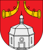
Blazon : "The silver Hörnerkirchen church in red, accompanied in the upper corners by two turned away golden hunting horns with the mouthpiece pointing upwards."
Culture and sights
The center of the village is the impressive octagonal church from 1752 . The master builder of the baroque central building was the architect Cay Dose , who also built the octagonal church in Rellingen and the Trinitatis church in Altona . After a severe fire in 1934, the church was rebuilt in a simplified manner. The church, crowned by an octagonal mansard roof with a lantern, has a separate, wooden belfry from 1781. The small church garden consists of a former cemetery on which there are still some old tombs. The church can only be visited during services.
Events
Since 2006 the medieval music and folk metal festival "Hörnerfest" has taken place near this town every year. In addition, the metal festival "Headbangers Open Air" has been held every year since 1998.
Sports
- Sports club Hörnerkirchen
- Dauenhof bowling club
literature
- Helmut Trede: Die Hörner Dörfer - From the history of Bokel, Bokelseß, Brande-Hörnerkirchen, Osterhorn and Westerhorn , self-published in 1989.
Web links
Brande-Hörnerkirchen community at the Hörnerkirchen office
Individual evidence
- ↑ North Statistics Office - Population of the municipalities in Schleswig-Holstein 4th quarter 2019 (XLSX file) (update based on the 2011 census) ( help on this ).
- ↑ Schleswig-Holstein topography. Vol. 2: Boren - Ellerau . 1st edition Flying-Kiwi-Verl. Junge, Flensburg 2002, ISBN 978-3-926055-68-2 , p. 75 ( dnb.de [accessed June 11, 2020]).
- ^ Federal Statistical Office (ed.): Historical municipality directory for the Federal Republic of Germany. Name, border and key number changes in municipalities, counties and administrative districts from May 27, 1970 to December 31, 1982 . W. Kohlhammer GmbH, Stuttgart / Mainz 1983, ISBN 3-17-003263-1 , p. 183 .
- ↑ Schleswig-Holstein's municipal coat of arms


