
Hart (Liebenfels municipality)
|
Hart ( Rotte ) village |
|||
|---|---|---|---|
|
|||
| Basic data | |||
| Pole. District , state | Sankt Veit an der Glan (SV), Carinthia | ||
| Judicial district | Sankt Veit an der Glan | ||
| Pole. local community | Liebenfels ( KG Pflausach , Sörgerberg ) | ||
| Coordinates | 46 ° 46 '22 " N , 14 ° 15' 3" E | ||
| height | 890 m above sea level A. | ||
| Residents of the village | 30 (January 1, 2020) | ||
| Building status | 14 (January 1, 2011 ) | ||
| Statistical identification | |||
| Locality code | 01685 | ||
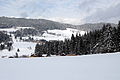
_von_Norden.jpg) Hart town center, view from the north |
|||
| Source: STAT : index of places ; BEV : GEONAM ; KAGIS | |||

Hart is a village in the municipality of Liebenfels in the Sankt Veit an der Glan district in Carinthia . The village has 30 inhabitants (as of January 1, 2020). It is mainly in the area of the cadastral community Pflausach , one house is in the area of the cadastral community Sörgerberg .
location
The village is located in the southwest of the Sankt Veit an der Glan district, west of Sörg , in the valley of the Harter Bach in the Wimitzer mountains . The houses around the Filialkirche hll belong to the village. Peter and Paul, Hof Fercher , located south of it halfway to the Gradenegg castle ruins , and - as the only house in the village that is located in the area of the cadastral community of Sörgerberg - the Saustaller farm east of the town center on the road to Sörg (house no. 6).
history
The place is mentioned as Harde in 1285 .
The place belonged to the tax district Gradenegg in the first half of the 19th century . When the local congregations were formed in the course of the reforms after the revolution of 1848/49, the place first became part of the municipality of Glantschach and in 1875 the municipality of Sörg . Since the merger of the municipalities of Sörg and Liebenfels in 1973, Hart has belonged to the municipality of Liebenfels.
Since 1967 the place has been served by a bus line from Sankt Veit an der Glan .
Population development
The following population figures were counted for the village:
- 1869: 6 houses, 34 inhabitants
- 1880: 5 houses, 40 inhabitants
- 1890: 5 houses, 50 inhabitants
- 1900: 8 houses, 64 inhabitants
- 1910: 8 houses, 43 inhabitants
- 1923: 6 houses, 40 inhabitants
- 1934: 50 inhabitants
- 1961: 9 houses, 51 inhabitants
- 2001: 14 buildings (14 of them with main residence) with 14 apartments and 12 households; 40 residents and 1 secondary residence cases
- 2011: 14 buildings, 30 residents
There is 1 workplace in the village (as of 2011; 2001: 1) and 9 agricultural and forestry operations (as of 2001).

Church of St. Peter and Paul, Hart

Church of St. Peter and Paul, Hart

southern entrance to Hart. House number 3 and 8

northern entrance to Hart. from the left house no.5, 11 (behind the church) and 9
below the houses Hart No. 12 and No. 14


_s%C3%BCdliche_Ortseinfahrt.jpg)


Individual evidence
- ↑ Statistics Austria: Population on January 1st, 2020 by locality (area status on January 1st, 2020) , ( CSV )
- ↑ a b Community Liebenfels (ed.): Community chronicle Liebenfels. 1998. p. 378.
- ^ Central Statistical Commission: Local Repertory of the Duchy of Carinthia. Based on the census of December 31, 1869. Carl Gerold's Sohn, Vienna 1872. P. 72.
- ^ KK Statistische Central-Commission (Ed.): Complete list of localities of the kingdoms and countries represented in the Reichsrathe according to the results of the census of December 31, 1880. Alfred Hölder, Vienna 1882. S. 60.
- ↑ KK Statistische Central-Commission (Hrsg.): Local repertories of the kingdoms and countries represented in the Austrian Reichsrathe. Revised based on the results of the census of December 31, 1890. V. Carinthia. Alfred Hölder, Vienna 1894. p. 61.
- ↑ KK Central Statistical Commission (ed.): Community encyclopedia of the kingdoms and countries represented in the Reichsrat. Revised based on the results of the census of December 31, 1900. V. Carinthia. KK Hof- und Staatsdruckerei, Vienna 1905. p. 82.
- ^ Central Statistical Commission (ed.): Special locations repertory of the Austrian countries. Edited on the basis of the results of the census of December 31, 1910. V. Carinthia. Verlag der Staatsdruckerei, Vienna 1918. p. 43.
- ^ Federal Statistical Office (ed.): Directory of Austria. Edited on the basis of the results of the census of March 7, 1923. Österreichische Staatsdruckerei, Vienna 1930. Section Carinthia, p. 18.
- ↑ Handwritten addendum to the 1923 local directory (Federal Statistical Office (Hrsg.): Local directory of Austria. Edited on the basis of the results of the census of March 7, 1923. Österreichische Staatsdruckerei, Vienna 1930.) with the signature II 28238 of the Klagenfurt University Library. Section Carinthia, p. 18.
- ^ Austrian Central Statistical Office: Directory of Austria. Edited on the basis of the results of the census of March 21, 1961. Österreichische Staatsdruckerei, 1965. p. 257.
- ↑ a b c Statistics Austria (Ed.): Local directory 2001 Carinthia. Vienna 2004. 112.
- ^ A b Office of the Carinthian regional government, regional statistical office: Carinthian local directory. Territorial status January 1, 2014. Klagenfurt, 2014.

Cadastral communities: friendly | Glantschach | Gradenegg | Hardegg | Liebenfels | Liemberg | Pflausach | Rosenbichl | Rottschaft Feistritz | Sörg | Soergerberg
Locations: Bärndorf | Beißendorf | Harrows I | Harrows II | Friendly | Gasmai | Glantschach | Gßeberg | Dig | Gradenegg | Grassendorf | Reason | Hardegg | Hard | Hoch-Liebenfels | Hohenstein | Kraindorf | Kulm | Ladein | Lebmach | Liebenfels | Liemberg | Lorberhof | Mailsberg | Metschach | Miedling | Moss | Pflausach | Plowing | Pulse | Puppitsch | Radelsdorf | Rasting | Reidenau | Rohnsdorf | Rosenbichl | Sörg | Sörgerberg | St. Leonhard | Chadam | Waggendorf | Wasai | Weitensfeld | Woitsch | Zmuln | Zojach | Zwattendorf | Two churches
(Former) parts of the village: Grientschach | Undergrowth | Schoberhof | Seidelhof | Divorce
Counting district: Liebenfels-Nord | Liebenfels-Süd | Sörg
Former communities: Community of Glantschach 1850–1875 | Hardegg municipality 1850–1958 | Liemberg municipality 1850–1958 | Municipality of Pulst 1850–1958 (of which 1850–1875 as municipality of Feistritz ) | Municipality of Sörg 1875–1973