
Rax
| Rax | ||
|---|---|---|
 Southeast view of the Rax from the Sonnwendstein . On the left the Heukuppe, the highest elevation of the Rax, and on the right the drop in the Höllental . |
||
| height | 2007 m above sea level A. | |
| location | Lower Austria and Styria , Austria | |
| Mountains | Rax Schneeberg Group | |
| Dominance | 12.1 km → Monastery coat of arms | |
| Notch height | 992 m ↓ Lahnsattel | |
| Coordinates | 47 ° 41 ′ 20 " N , 15 ° 41 ′ 22" E | |
|
||
| rock | Wetterstein lime | |
| Age of the rock | Ladinium | |
| First ascent | around 1575 by Charles de l'Écluse (tourist) | |
| Development | Rax cable car (1925) | |

The Rax (also Raxalpe on older maps ) is one of the two eponymous mountain ranges of the Rax-Schneeberg group . It lies on the border between the federal states of Styria and Lower Austria , about 80 km south of Vienna , and is one of Vienna's local mountains . Thanks to its extensive high plateau , which can be accessed by the Rax cable car , it is particularly suitable for snowshoeing and hiking with children .
The highest elevation of the Rax is the Heukuppe with 2007 m above sea level. A. , which is entirely in Styria . The highest peak in Lower Austria is the Scheibwaldhöhe at 1943 m . The mountain range encompasses most of the catchment area of the I. Vienna High Spring Water Pipeline .
geography


Location and landscape
The Rax is located about 85 km south-west of Vienna, 60 km south of Sankt Pölten , a good 40 km west of Wiener Neustadt and 12 km north-west of the Semmering . The most important valley locations are
- Reichenau an der Rax , Hirschwang an der Rax and Schwarzau in the mountains , on both sides of the Hell Valley of the Schwarza ,
- as well as chapels in the upper Mürz Valley and Altenberg an der Rax above.
The floor stretches for about 13 km from the southwest to the northeast and has a highly structured plateau of around 34 km². The summit corridor rises far above the tree line and is a karst plateau.
Boundary and neighboring mountain groups
According to the Austrian mountain group structure according to Trimmel , the group has the number 1853 and belongs as a subgroup to the Schneeberg Alps ( 1850), a subgroup of the Lower Austrian Limestone Alps (1800). The Alpine Club division of the Eastern Alps (AVE) places them in the Rax-Schneeberg Group of the Northern Eastern Alps .
It is bounded by Trimmel (clockwise from the north, border lines in italics, high and low points with kote):
- in the northeast of Schwarza from Singerin down through the Höllental to the mouth of the Preinerbach ( 490 m above sea level ) between Hirschwang and Reichenau to the Schneeberg (1854)
- in the south Preinerbach - Rettenbach via Edlach and Prein - Preiner Gscheid ( 1070 m above sea level ) - Raxenbach via Raxen to the mouth ( 725 m above sea level , above Kapellen) to the area west of the Semmering Pass (2861) ∗
- in the northwest of Altenberger Bach upwards via Altenberg - Naßkamm (notch 1210 m above sea level ) - Reissbach to Hinternaßwald to Schneealpe (1851)
- in the north Nassbach via Naßwald to Singerin to the Sonnleitstein (1852) ∗∗
- ∗Part of the Semmering area 2860, group of the Cetian Alps and the hill country of eastern Styria and Burgenland in the Central Alps ; in the AVE structure still part of the Rax-Schneeberg group, but geologically very different.
- ∗∗After AVE already Gutenstein Alps
Outline and summit


The main stock of the group is that of the Heukuppe ( 2007 m above sea level ) in the southwest, with the Gamseck ( 1857 m above sea level ) as the western foothill. He strokes in an east-west direction.
At the east end, the main ridge started, which runs between the high valley Krummtal and the Großer Höllental , a side valley of the Höllental of the Schwarza. North-northeast over Predigtstuhl ( 1902 m above sea level ) to Dreimarkstein ( 1948 m above sea level ), an old Styrian-Austrian border mountain.
A second plateau begins at Dreimarkstein, with the Bieskogel ( 1924 m above sea level ), Waxriegel ( 1913 m above sea level ), Scheibwaldhöhe ( 1943 m above sea level ) and several other peaks, which then rise steeply over the Kloben ( 1697) m above sea level ) and whose Klobenwand falls into the Höllental and surrounds the Großer Kesselgraben eastward in a ridge to the Nasstal .
South of the Großer Höllental a ridge runs over the Preinerwand ( 1783 m above sea level ) to Reichenau. The area to the Höllental is also heavily divided into ridges and valleys.
The Heukuppe has a dominance of 12.1 km to the monastery coat of arms . The loop height is 992 m, the reference point is the Lahnsattel .
geology
The Raxstock is made up of Wetterstein limestone (formerly "lower Alpine limestone "), a stable and finely structured limestone that builds up the typical, mighty, steep-sided mountain ranges of the limestone Alps . It is a reef limestone , i.e. an old coral reef, comes from the Ladinium (Middle Triassic) and is around 230 million years old. When the Alps unfolded it slid to the east.
The western and southern edges of the massif are Werfen formation , underlain by the Grauwackenzone , which is a hydrogeological barrier layer that rises from 700 m near Naßwald to 1300 m on the Naßkamm, on the Preiner Gscheids is still at the same height, and then up to Hirschwang drops about 500 m above sea level. This zone probably runs completely through under the Rax-Schneeberg group. From Hinternaßwald over the lower Kesselboden and the Kleine Höllental there is a disturbance that can be assigned to the SEMP system ( Salzach – Enns – Mariazell – Puchberg-Lineament ), one of the fundamental transverse shifts in the Eastern Alps. Another leaf shift runs through the massif from Preiner Gscheid via the Große Höllental. The source horizon appears on the one hand around Hinternaßwald ( Übeltalquelle , Albertwiesquelle , Schütterlehnenquelle and Reistalquelle ), but on the other hand in the powerful Höllental springs (pouring up to 100,000 m³ daily), which can be seen as the "main drainage" of the Raxstock. This geological situation was made possible by the I. Vienna High Spring Water Pipeline , which collects all these springs and circles the Rax massif to the northeast.
Otherwise, the Nasstal and Höllental (but this more on the Schneeberg side) are rich in caves, as is the high plateau, especially the western slopes of the Heukuppenstock.
natural reserve

The Raxalpe is part of the European Protected Area Northeastern Randalpen: Hohe Wand – Schneeberg – Rax and the Rax – Schneeberg landscape protection area in Lower Austria as well as the Veitsch – Schneealpe – Raxalpe landscape protection area and the Mürzer Oberland nature park in Styria. In addition, the entire Rax – Schneeberg – Schneealpe water conservation area is a water reserve .
history
The name Rax (from Raxalpe after the place Raxen ) is derived from a rahse ( rough , sparsely overgrown) area (1327 rakes , dialect Rachs ).
The first known alpine ascent took place around 1575 by the botanist Charles de l'Écluse .
The publication of the first Rax guide in 1894, in which the author Fritz Benesch attempted to define the first alpine difficulty rating with a "comparative ranking of the climbs according to their difficulty", is important in terms of alpine history. This Benesch scale had seven levels of difficulty, I was the most difficult, VII the easiest. The Raxalpe is also considered the birthplace of the Vienna Alpine School . For many decades, the Rax was Viktor Frankl's refuge and climbing area . Several via ferratas and a street in Reichenau bear his name.
The founding of the Vienna Alpine Rescue Committee , the first mountain rescue service in the world, was inspired by an avalanche accident with three fatalities in 1896 .
Thanks to the Rax cable car in Hirschwang , which was the first tourist cable car in what is now the Republic of Austria (construction started in 1925), the extensive Rax high plateau is an easily accessible excursion area. Many of the trails were built by the Austrian Alpine Association and Naturefriends at the beginning of the 20th century. The steep flanks of the plateau can now be conquered via a variety of via ferratas of various degrees of difficulty.
In 1963 Georg Kreisler published the bizarre chanson of Max on the Rax .
Development, tourism and sightseeing
| Basic data | |
|---|---|
| Number of lifts: | 2 |
| Number of kilometers of slopes: | 14 km |
| Lowest point of the ski area: | 535 m above sea level A. |
| Highest point of the ski area: | 1630 m above sea level A. |
Thanks to the cable car, the mountain is particularly popular with day trippers from Lower Austria and Vienna . But it is also interesting for mountaineers - summit trips as well as demanding crossings - and also for climbers.
Winter sports on the Rax
In winter, in addition to the cable car, the Rax offers a small area with a ski lift located on the high plateau, but for Lower Austria it is quite snow-sure. The slopes in the ski area have the greatest difference in altitude of all Lower Austrian ski areas, although these are not groomed slopes. There are groomed slopes only along the drag lift. (Note: the operation of the drag lift and thus the slopes were discontinued from the 2017/2018 season).
Furthermore, routes from the mountain station over the high plateau offer opportunities for ski touring and snowshoeing in an area that is relatively safe from avalanches. The high plateau with its height differences and the relative snow reliability offer a very good practice option for beginners and slightly advanced. Especially in winter, the Rax is often climbed in combination with a hike and snowshoe hike or ski tour.
The route from the mountain station to the Otto-Schutzhaus is very popular in summer and winter so you can hike in the snow without aids. In addition, there is the possibility of tobogganing , crossblading, or a ride with the RuckXBob (sledge, bob and backpack in one).
Huts in the Raxalpen area
- Huts in the Raxalpen area
Mountain inn

Habsburg house

Karl Ludwig House

Otto refuge

New lake hut

Gloggnitzerhütte

Wax bar house

Reissthalerhütte

Wolfgang Dirnbacher Hut

Raxgmoa hut and Hans Nemecek service hut

.JPG)
.JPG)
.JPG)


- On the upper Naßkamm (Gamsecksteig) in the west of the Rax. Formerly open shelter, which had been closed since March 2011 due to the risk of collapse and was demolished in 2018.
- On the upper Naßkamm (Gamsecksteig) in the west of the Rax; private and not managed.
- Around one kilometer west of the Großer Höllental or approx. 600 m north-northwest of the Klobentörl at 1548 m . Originally a holding hut, it was expanded in 1932/34, at which point the hut's current external dimensions were roughly achieved. The owner is the municipality of Vienna and the operator of the ÖGV (only open on Saturdays from 2 p.m., Sundays and public holidays).
- Located on the northwest side of the Rax massif on the state border between Lower Austria and Styria at 1786 m . The operator of the refuge, which opened in 1899, is the ÖGV.
- In the south of the Rax massif, between Heukuppe and Predigtstuhl, and four kilometers northwest of Preiner Gscheid at 1804 m . The hut named after Karl Ludwig was built in 1876/78. The operator is the ÖTK.
- New Seehütte ( 47 ° 42 ' N , 15 ° 44' O ) , also Höllentaler woodcutter hut designated
- Northwest of the Preinerwand or northeast of the Predigtstuhl at 1643 m . The previous building was built in 1894 and the current one from 1951 to 1954. The operator is ÖTK.
- Located in the southeast of the Rax massif, at the foot of the Jakobskogel and about one kilometer west of the Raxseilbahn mountain inn at 1644 m . The hut named after Archduke Otto was built in 1892/93 and expanded several times. The operator is the OeAV .
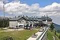
- Summit station of the Rax cable car : In the east of the Rax massif at 1547 m . Private, built around 1925 as part of the construction of the cable car.
- On the Trinksteinsattel at the end of the Großer Höllental at an altitude of 1858 m . An open shelter of the mountain rescue service , which was built in 1914 on the initiative of the Alpine Society Raxgmoa . In 1941/42 a mountain rescue service hut was added to the Raxgmoa hut and named after the alpinist and sports functionary Johann (Hans) Nemecek (Hans Nemecek service hut).
- On the Reisstalersteig in the south of the Rax; private and not cultivated (built 1888).
- South-east of the Predigtstuhl at the entrance to the Siebenbrunnkessel or north of Preiner Gscheid , just below the tree line at 1361 m . The owners of the hut built in 1923/24 are Naturefriends .
- On the upper Gaislochboden in the middle of the Rax (valley head of the Großer Höllental , 1477 m ); ÖTK shelter hut open all year round, not managed.
Hikes and climbs


- (Selection)
- Alpenvereinssteig : Großes Höllental - Otto-Schutzhaus
- Altenbergsteig : Altenberg - Heukuppe
- Alter Wetterkogelsteig : easy bypassing of the Schrofenwand of the Gretchensteig
- Amaliensteig : Preiner Gscheid - Heukuppe
- Bärenloch : Hinternasswald - Bärengraben
- Bismarcksteig : Karl Ludwig House - New Seehütte
- Erected in 1899 by the alpine society "Reisstaler" and restored in 1986 by the PES.
- Brandschneide : Kaiserbrunn - Raxbahn mountain station
- Big and small fox hole: Reisstalerhütte - Heukuppe
- Gaislochsteig : Großes Höllental - Wolfgang Dirnbacher Hut
- Göbl-Kühn-Steig : Waxriegelhaus - Neue Seehütte
- Built in 1921 and named after the functionaries Franz Göbl and Henry Kühnach of the Alpine Society "D'Holzknecht".
- Gamsecksteig : Nasskamm - Grasbodenalm
- Opened in 1875 by the ÖTK as the "first rock climbing for tourists on the Rax". The trail leads over the west-facing rock face of the Zahmer Gamseck to the highest point of the Raxalpe, the Heukuppe. The starting point is Hinternaßwald, which has to be overcome around 1300 meters in altitude.
- Gretchensteig : Preiner Gscheid - Karl Ludwig House
- Großes Wolfstal : Kaiserbrunn - Otto-Schutzhaus (unmarked, ski run)
- Großer Kesselgraben : Höllental - Gloggnitzer Hütte (ski run)
- Gsolhirnsteig : Hirschwang at the Rax - Raxbahn mountain station
- Gustav-Jahn-Steig : connection Alpenvereinssteig - exit Gaislochsteig
- Hans-von-Haid-Steig : Prein on the Rax - Preiner wall
- Hoyossteig : Großes Höllental - Rudolfsteig
- Kaisersteig : Rehboden - Scheibwald
- Karl-Kantner-Steig : Waxriegelhaus - Karl-Ludwig-Haus
- Kontrußsteig : Reisstalerhütte - Waxriegelhaus
- Martinssteig (Neuer Wetterkogelsteig): Reisstalerhütte - Karl-Ludwig-Haus
- Peter-Jokl-Steig : Hinternasswald - Scheibwald
- Preinerwandsteig : Prein an der Rax - Preiner Wand
- Preintalersteig : Großes Höllental - Wachthüttelkamm
- Reisstalersteig : Preiner Gscheid - Raxenmäuer - Heukuppe
- Erected in 1887 by the "Alpine Gesellschaft Reisstaler" founded in 1881, which still looks after the climb (as of 2012). During a winter ascent of 1896, three well-known Viennese mountaineers were killed in an accident. The accident triggered the founding of the world's first mountain rescue organization .
- Rudolfssteig : Höllental - Klobentörl
- Schlangenweg : Preiner Gscheid - Siebenbrunnenkessel - Karl-Ludwig-Haus
- Created in 1876 as part of the construction of the Karl Ludwig House for material transport. It leads in serpentines over the Siebenbrunnenkessel to the southwest high plateau and is the most popular ascent from Preiner Gscheid.
- Schüttersteig : connecting road Nasswald / Hinternasswald - Scheibwald
- Sea route : Otto-Schutzhaus - Neue Seehütte
- Teufelsbadstubensteig : Großes Höllental - Wachthüttelkamm
- Törlweg : Knappenhof - Otto refuge
- Wachthüttelkammsteig : Höllental - Otto-Schutzhaus
- Waxriegelsteig : Predigtstuhl - Waxriegelhaus
- Wetterkogelsteig : connection Gretchensteig - exit Wetterkogel
- Wildes Gamseck : Nasskamm - Grasbodenalm
- Wild trail : Hinternasswald - Grasbodenalm
- Zikafahnlsteig : Scheibwald - Habsburghaus
Memorials on the Rax
- Memorials on the Rax
The Raxkircherl next to the Karl-Ludwig-Haus

The hero monument of the ÖTK on the Heukuppe

The Fritz Benesch memorial next to the Otto refuge

Daniel Innthaler monument, immediately south of the Habsburg house

The Karl-Jahn-Marterl next to the Habsburg house

Memorial plaque at the Höllentalaussicht


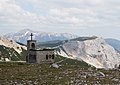
- Raxkircherl or Raxkirche ( 47 ° 41 ' N , 15 ° 42' O )
- A small chapel, around 200 m south of the Karl-Ludwig-Haus , in memory of the alpinists who died in the mountains. The little church was built by the builder Hermann Kubacsek according to the plans of the architect Edmund Zacher via a committee headed by the alpinist developer of the Hohe Wand , cave explorer, president of the Austrian Tourist Club (ÖTK) and cathedral prelate Alois Wildenauer (1877-1967) Solemnly consecrated on September 20, 1936 by Cardinal Archbishop Theodor Innitzer . Although it belongs to the diocese of Graz-Seckau , it is subordinate to the Vienna parish Prein ( Vicariate Unter dem Wienerwald ); Mountain masses are occasionally organized by various parishes.
- Heroes Monument ( 47 ° 41 ′ N , 15 ° 41 ′ E )
- On the highest elevation of the Rax, the Heukuppe, the ÖTK erected a memorial to the victims of the World War in 1926. The inscription has been changed several times and currently reads (as of 2012): “In memory of the members of the Austrian Tourist Club who died for their homeland in the World Wars from 1914 to 1918 and 1939 to 1945, and those members who found their death in the mountains to have."
- Fritz Benesch Monument ( 47 ° 43 ′ N , 15 ° 46 ′ E )
- About 50 m south of the Otto-Schutzhaus there is a truncated pyramid-shaped monument with a plaque in honor of Fritz Benesch , the author of the first alpine Rax and Schneeberg guides (1894).
- Daniel-In (n) nthaler Memorial ( 47 ° 43 ' N , 15 ° 42' O )
- Immediately south of the Habsburg House , a memorial was erected in 1925 in memory of Daniel Innthaler (1847–1923), mountain guide and first to climb the north face of the Planspitze (1885).
- Karl-Jahn-Marterl (Jahnkreuz) ( 47 ° 43 ′ N , 15 ° 42 ′ E )
- About 250 m southeast of the Habsburg House, a Marterl reminds of the tenant of the Habsburg House, Karl Jahn, who died in a snow storm on February 8, 1919.
- Memorial plaque at the Höllentalaussicht ( 47 ° 43 ′ N , 15 ° 45 ′ E )
- There is a memorial plaque for Hedwig Kronich, landlady of the Otto refuge and wife of Camillo Kronich, directly at the Höllental view with a view of the Große Höllental .
Transmitters
The Reichenau Raxalpe transmitter is located approx. 100 m from the mountain station of the Rax cable car and broadcasts radio programs for the surrounding villages.
literature
- Richard Artner: Hazard potential of spring protection areas as a result of tourist use - illustrated using the example of Rax . Thesis. University of Vienna, Vienna 2004 ( OBV . Full text online; PDF; 3.7 MB , accessed on May 20, 2015).
- Fritz Benesch: The Raxalpe and the Wiener Schneeberg. In: Journal of the German Alpine Association / Journal of the German and (the) Austrian Alpine Association , year 1898, (XXIX. Year), pp. 197–228 (online at ANNO ). .
Web links
- Rax cable car
- Activities on the Rax (and Semmering) and guest information - Wiener-Alpen.at
- High resolution panorama image of the Rax with snapshots
- RaxWandern.at - guided hikes in the Rax area
- J (acob) Frank: Christmas on the Rax (part 1/2). In: Der Naturfreund , year 1902, No. 2, February 15, 1902 (VI. Year), p. 9 f. (Online at ANNO ). ,
- -: - (Part 2/2). In: Der Naturfreund , year 1902, No. 3, March 15, 1902 (VI. Year), p. 18 f. (Online at ANNO ). .
- Heinrich Büchlbauer: The arrival of winter on the Rax. (...) Two photos by the author. In: Der Naturfreund , born 1914, XVIII. Volume, p. 15 f. (Online at ANNO ). .
- The Rax - the most visited mountain in the world. Heroes and victims of Vienna's local mountain. In: Das Kleine Blatt , No. 1/1937 (11th year), January 1, 1937, p. 12 f. (Online at ANNO ). .
Individual evidence
- ↑ Vienna Alps in Lower Austria ( Memento of the original from November 11, 2011 in the Internet Archive ) Info: The archive link was inserted automatically and has not yet been checked. Please check the original and archive link according to the instructions and then remove this notice. ; Retrieved June 2, 2012
- ↑ Lukas Plan: Verbal description of the delimitation of the subgroups of the Austrian cave directory . Status: Jan 08 2008. Ed .: Association of Austrian Speleologists. ( hoehle.org [PDF; 321 kB ; accessed on May 15, 2018]).
- ↑ Harald Lobitzer: Report 1984/85 on facial investigations in the Wetterstein limestone of the Rax plateau on sheet 104 Mürzzuschlag. In: Yearbook of the Federal Geological Institute. Volume 129, Issue 2, 1986, ISSN 0016-7800 , pp. 411-413 ( article, pdf , geologie.ac.at).
- ^ Hermann Stadler, Ralf Benischke, Elmar Strobl: Hydrogeologie Schneeberg / Rax. Final report. Study by the Institute for Water Resource Management Hydrogeology and Geophysics, on behalf of the City of Vienna MA31 (as part of KATER II), Graz, March 2008, especially 3.1.6. Interpretation of the hydrogeological conditions: 1. Geological framework , p. 12 f and 2. Fault pattern 13 f ( pdf , on ccwaters.eu, accessed May 7, 2015, there page number +1).
- ↑ Heinz-Dieter Pohl : Austrian mountain names , Onoma 33 (1997) 131–151
- ↑ a b c Kurt Schall, Harald Braun, Alfred Kapfenberger: Schneeberg and Raxalpe . 1st edition. Verlag Kurt Schall, Vienna 1989, OBV (because ISBN is incorrect). (Section Schneeberg and Rax - the day before yesterday and yesterday by Karl Lukan).
- ↑ Skiplan 2017/2018 - Information about the discontinuation of the ski lifts. Retrieved August 16, 2019 .
- ↑ Snowshoeing on the Rax. Retrieved August 16, 2019 .
- ^ Alpine Society Gamsecker ; Retrieved June 4, 2012
- ^ Chronicle of the Gloggnitzerhuette ; Retrieved June 2, 2012
- ↑ Raxalpen-Berggasthof , raxalpe.com
- ↑ Raxgmoa Hut. im-muerztal.at; accessed on May 13, 2015
- ↑ Reichenau mountain rescue: Hans Nemecek service hut on the Trinksteinsattel ; accessed on May 13, 2015
- ↑ Nemecek, Johann (1891–1949), alpinist and sports official. In: Austrian Biographical Lexicon 1815–1950 (ÖBL). Volume 7, Verlag der Österreichischen Akademie der Wissenschaften, Vienna 1978, ISBN 3-7001-0187-2 , p. 64.
- ^ Austrian Tourist Club : Wolfgang Dirnbacher Hut, 1477 m ; Retrieved June 29, 2012
- ↑ The old sea hut ; accessed on August 16, 2019
- ^ Lower Austrian news : Vienna Alps; Edition 2011 ( Memento of the original from April 29, 2014 in the Internet Archive ) Info: The archive link was inserted automatically and has not yet been checked. Please check the original and archive link according to the instructions and then remove this notice.
- ↑ Wolfgang Kos (ed.): The conquest of the landscape: Semmering, Rax, Schneeberg. Catalog for the Lower Austrian State Exhibition, Gloggnitz Castle, 1992 . Falter Verlag, Vienna 1992, ISBN 3-85460-062-3 .
- ↑ Bergnews.com: Gamsecksteig ; Retrieved June 29, 2012
- ↑ www.alpenlandmagazin.at: route description , accessed on July 15, 2013
- ↑ Hike over the Schlangenweg to the Karl Ludwig House. Retrieved August 16, 2019 .
- ↑ Hike to Altenbergerhof via Almgasthof Moassa (from Preiner Gscheid). Retrieved August 16, 2019 .
- ↑ Alpine Society tear dollars. Retrieved on August 16, 2019 (German).
- ^ Karl-Ludwig-Haus: Reissthalersteig ; Retrieved June 17, 2012
- ↑ Karl Ludwig House: Schlangenweg ; Retrieved June 17, 2012
- ↑ www.alpenlandmagazin.at: route description , accessed on July 15, 2013.
- ↑ Archdiocese of Vienna: 70 years of the little church on the Rax ( page no longer available , search in web archives ) Info: The link was automatically marked as defective. Please check the link according to the instructions and then remove this notice. ; Retrieved June 1, 2012
- ↑ Austrian Tourist Club: Raxkircherl when Karl Ludwig House at the Rax: History . Retrieved June 1, 2012.
- ↑ So Seebenstein, see Mountain Fair in Raxkircherl, September 6, 2014. reichenau.at, accessed 9 May 2014.
- ^ Wolfgang Greisenegger: Theaterwelt, Welttheater: Tradition & Modernism around 1900.